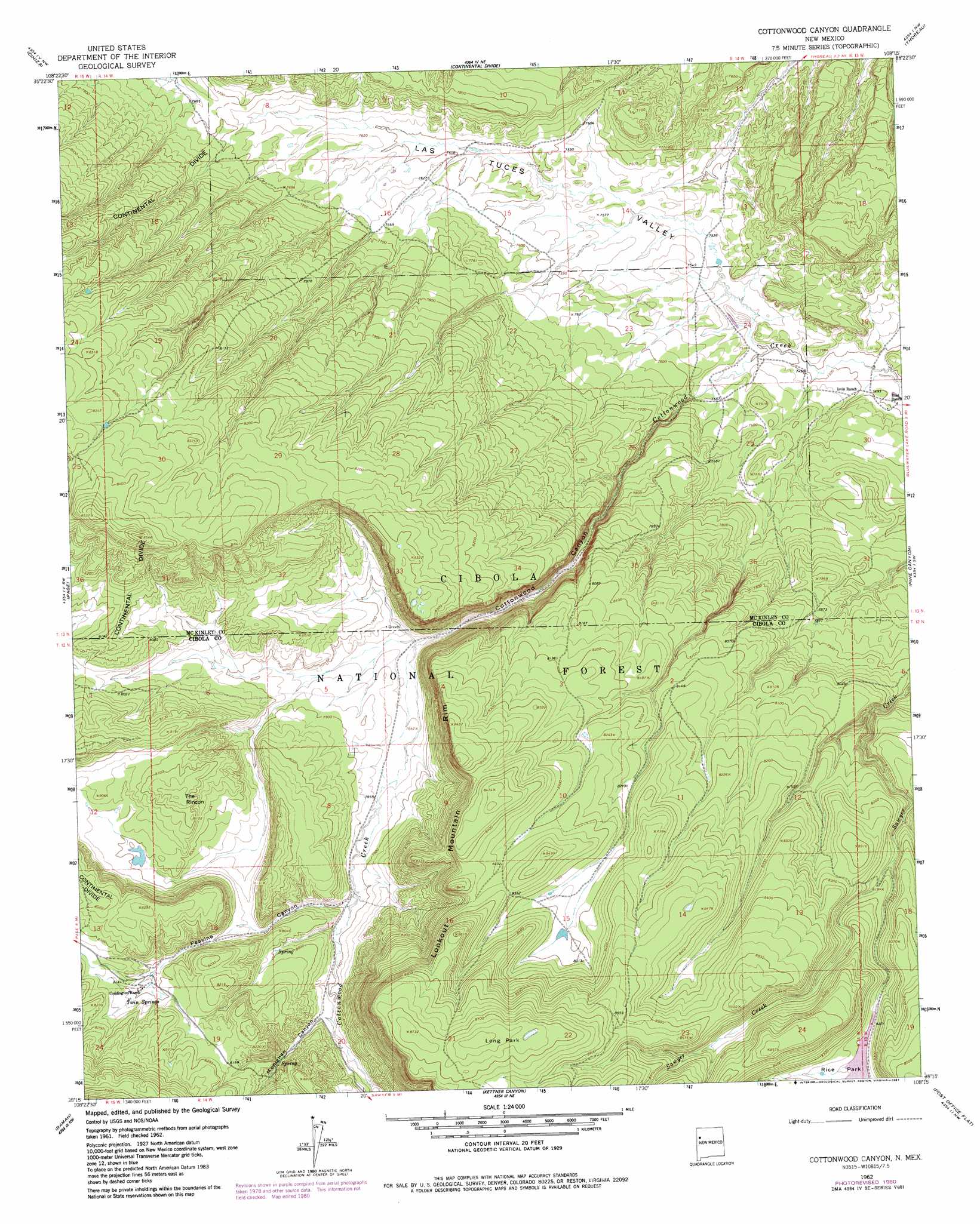
Cottonwood Canyon Topo Map New Mexico
To zoom in, hover over the map of Cottonwood Canyon
USGS Topo Quad 35108c3 - 1:24,000 scale
| Topo Map Name: | Cottonwood Canyon |
| USGS Topo Quad ID: | 35108c3 |
| Print Size: | ca. 21 1/4" wide x 27" high |
| Southeast Coordinates: | 35.25° N latitude / 108.25° W longitude |
| Map Center Coordinates: | 35.3125° N latitude / 108.3125° W longitude |
| U.S. State: | NM |
| Filename: | o35108c3.jpg |
| Download Map JPG Image: | Cottonwood Canyon topo map 1:24,000 scale |
| Map Type: | Topographic |
| Topo Series: | 7.5´ |
| Map Scale: | 1:24,000 |
| Source of Map Images: | United States Geological Survey (USGS) |
| Alternate Map Versions: |
Cottonwood Canyon NM 1961, updated 1981 Download PDF Buy paper map Cottonwood Canyon NM 1962, updated 1966 Download PDF Buy paper map Cottonwood Canyon NM 1995, updated 1998 Download PDF Buy paper map Cottonwood Canyon NM 2011 Download PDF Buy paper map Cottonwood Canyon NM 2013 Download PDF Buy paper map Cottonwood Canyon NM 2017 Download PDF Buy paper map |
| FStopo: | US Forest Service topo Cottonwood Canyon is available: Download FStopo PDF Download FStopo TIF |
1:24,000 Topo Quads surrounding Cottonwood Canyon
Church Rock |
Pinedale |
Mariano Lake |
Hosta Butte |
Casamero Lake |
Fort Wingate |
Ciniza |
Continental Divide |
Thoreau |
Thoreau Ne |
Upper Nutria |
Page |
Cottonwood Canyon |
Pine Canyon |
Prewitt |
Burned Timber Canyon |
Ramah |
Kettner Canyon |
Post Office Flat |
Mount Sedgwick |
Pescado |
Togeye Lake |
El Morro |
Valle Largo |
Paxton Springs |
> Back to 35108a1 at 1:100,000 scale
> Back to 35108a1 at 1:250,000 scale
> Back to U.S. Topo Maps home
Cottonwood Canyon topo map: Gazetteer
Cottonwood Canyon: Dams
Rice Park Dam elevation 2509m 8231′Cottonwood Canyon: Parks
Long Park elevation 2669m 8756′Cottonwood Canyon: Reservoirs
Bill Morgan Tank elevation 2471m 8106′Black Stock Tank elevation 2531m 8303′
Corral Tanks One and Two elevation 2393m 7851′
Prairie Dog Tank elevation 2510m 8234′
Roadside Tank elevation 2505m 8218′
Rock Dam elevation 2303m 7555′
Rock Stock Tank elevation 2492m 8175′
Section Twelve elevation 2445m 8021′
Slab Pole Tank elevation 2524m 8280′
Thurlow Tank elevation 2304m 7559′
Windmill Tank elevation 2528m 8293′
Cottonwood Canyon: Springs
Twin Springs elevation 2470m 8103′Cottonwood Canyon: Summits
The Rincon elevation 2489m 8166′Cottonwood Canyon: Valleys
Cottonwood Canyon elevation 2286m 7500′Monighan Canyon elevation 2415m 7923′
Peavine Canyon elevation 2403m 7883′
Cottonwood Canyon: Wells
10006 Water Well elevation 2313m 7588′Cottonwood Canyon digital topo map on disk
Buy this Cottonwood Canyon topo map showing relief, roads, GPS coordinates and other geographical features, as a high-resolution digital map file on DVD: