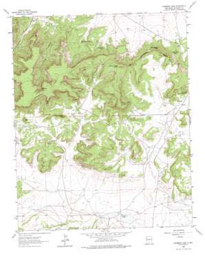
Casamero Lake Topo Map New Mexico
To zoom in, hover over the map of Casamero Lake
USGS Topo Quad 35108e1 - 1:24,000 scale
| Topo Map Name: | Casamero Lake |
| USGS Topo Quad ID: | 35108e1 |
| Print Size: | ca. 21 1/4" wide x 27" high |
| Southeast Coordinates: | 35.5° N latitude / 108° W longitude |
| Map Center Coordinates: | 35.5625° N latitude / 108.0625° W longitude |
| U.S. State: | NM |
| Filename: | o35108e1.jpg |
| Download Map JPG Image: | Casamero Lake topo map 1:24,000 scale |
| Map Type: | Topographic |
| Topo Series: | 7.5´ |
| Map Scale: | 1:24,000 |
| Source of Map Images: | United States Geological Survey (USGS) |
| Alternate Map Versions: |
Casamero Lake NM 1963, updated 1965 Download PDF Buy paper map Casamero Lake NM 1963, updated 1974 Download PDF Buy paper map Casamero Lake NM 2010 Download PDF Buy paper map Casamero Lake NM 2013 Download PDF Buy paper map Casamero Lake NM 2017 Download PDF Buy paper map |
1:24,000 Topo Quads surrounding Casamero Lake
> Back to 35108e1 at 1:100,000 scale
> Back to 35108a1 at 1:250,000 scale
> Back to U.S. Topo Maps home
Casamero Lake topo map: Gazetteer
Casamero Lake: Capes
Rocky Point elevation 2445m 8021′Casamero Lake: Gaps
Wheat Grass Pass elevation 2315m 7595′Casamero Lake: Mines
Tiejen Prospect elevation 2173m 7129′Uranium Deposit elevation 2359m 7739′
Casamero Lake: Reservoirs
Casamero Lake elevation 2148m 7047′Casamero Lake: Ridges
Red Butte elevation 2334m 7657′Casamero Lake: Springs
Blue Water Spring elevation 2177m 7142′Little Water Spring elevation 2198m 7211′
Many Mexican Spring elevation 2208m 7244′
Owl Spring elevation 2341m 7680′
Casamero Lake: Summits
Big Point elevation 2495m 8185′Cream Colored Rock elevation 2287m 7503′
The Cup elevation 2325m 7627′
Wheat Grass Butte elevation 2409m 7903′
White Water Mesa elevation 2206m 7237′
Casamero Lake: Valleys
Long Canyon elevation 2143m 7030′Casamero Lake: Wells
10014 Water Well elevation 2159m 7083′10018 Water Well elevation 2246m 7368′
16B-37 Water Well elevation 2195m 7201′
16T588 Water Well elevation 2154m 7066′
16T-594 Water Well elevation 2203m 7227′
16T-597 Water Well elevation 2202m 7224′
Casamero Lake digital topo map on disk
Buy this Casamero Lake topo map showing relief, roads, GPS coordinates and other geographical features, as a high-resolution digital map file on DVD:


