Hosta Butte Topo Map New Mexico
To zoom in, hover over the map of Hosta Butte
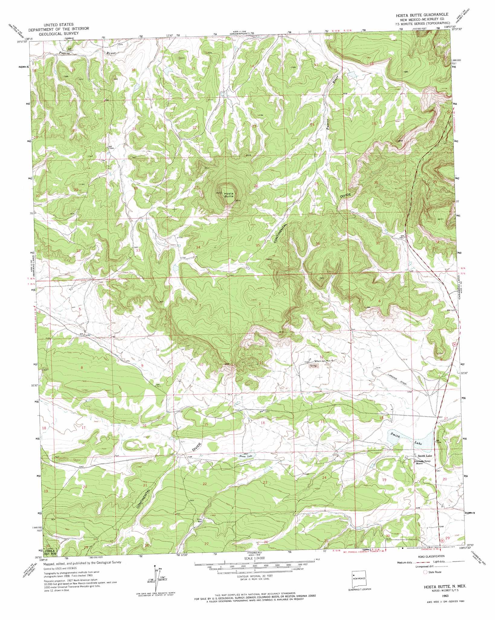
USGS Topo Quad 35108e2 - 1:24,000 scale
| Topo Map Name: | Hosta Butte |
| USGS Topo Quad ID: | 35108e2 |
| Print Size: | ca. 21 1/4" wide x 27" high |
| Southeast Coordinates: | 35.5° N latitude / 108.125° W longitude |
| Map Center Coordinates: | 35.5625° N latitude / 108.1875° W longitude |
| U.S. State: | NM |
| Filename: | o35108e2.jpg |
| Download Map JPG Image: | Hosta Butte topo map 1:24,000 scale |
| Map Type: | Topographic |
| Topo Series: | 7.5´ |
| Map Scale: | 1:24,000 |
| Source of Map Images: | United States Geological Survey (USGS) |
| Alternate Map Versions: |
Hosta Butte NM 1963, updated 1965 Download PDF Buy paper map Hosta Butte NM 1963, updated 1974 Download PDF Buy paper map Hosta Butte NM 2010 Download PDF Buy paper map Hosta Butte NM 2013 Download PDF Buy paper map |
1:24,000 Topo Quads surrounding Hosta Butte
Toyee |
Standing Rock |
Antelope Lookout Mesa |
Becenti Lake |
Seven Lakes |
Oak Spring |
Dalton Pass |
Crownpoint |
Heart Rock |
Laguna Castillo |
Pinedale |
Mariano Lake |
Hosta Butte |
Casamero Lake |
Borrego Pass |
Ciniza |
Continental Divide |
Thoreau |
Thoreau Ne |
Goat Mountain |
Page |
Cottonwood Canyon |
Pine Canyon |
Prewitt |
Bluewater |
> Back to 35108e1 at 1:100,000 scale
> Back to 35108a1 at 1:250,000 scale
> Back to U.S. Topo Maps home
Hosta Butte topo map: Gazetteer
Hosta Butte: Dams
Childers Smith Reservoir Dam elevation 2205m 7234′Hosta Butte: Gaps
Satan Pass elevation 2286m 7500′Hosta Butte: Mines
Black Jack Mine Number One elevation 2268m 7440′Hosta Butte: Populated Places
Smith Lake elevation 2213m 7260′Hosta Butte: Reservoirs
House Lake elevation 2266m 7434′Smith Lake elevation 2206m 7237′
Hosta Butte: Summits
Hosta Butte elevation 2628m 8622′Hosta Butte: Wells
10013 Water Well elevation 2291m 7516′16T-558 Water Well elevation 2309m 7575′
Ruby 3-4 Water Well elevation 2282m 7486′
Hosta Butte digital topo map on disk
Buy this Hosta Butte topo map showing relief, roads, GPS coordinates and other geographical features, as a high-resolution digital map file on DVD: