Pinedale Topo Map New Mexico
To zoom in, hover over the map of Pinedale
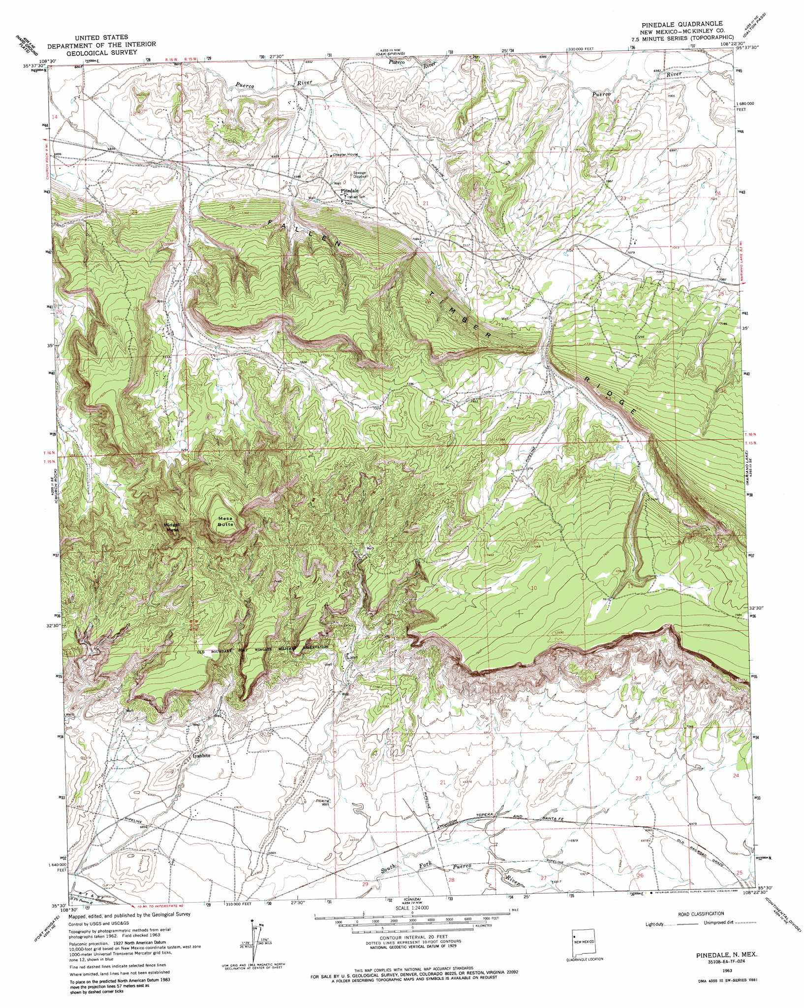
USGS Topo Quad 35108e4 - 1:24,000 scale
| Topo Map Name: | Pinedale |
| USGS Topo Quad ID: | 35108e4 |
| Print Size: | ca. 21 1/4" wide x 27" high |
| Southeast Coordinates: | 35.5° N latitude / 108.375° W longitude |
| Map Center Coordinates: | 35.5625° N latitude / 108.4375° W longitude |
| U.S. State: | NM |
| Filename: | o35108e4.jpg |
| Download Map JPG Image: | Pinedale topo map 1:24,000 scale |
| Map Type: | Topographic |
| Topo Series: | 7.5´ |
| Map Scale: | 1:24,000 |
| Source of Map Images: | United States Geological Survey (USGS) |
| Alternate Map Versions: |
Pinedale NM 1963, updated 1967 Download PDF Buy paper map Pinedale NM 1963, updated 1986 Download PDF Buy paper map Pinedale NM 2010 Download PDF Buy paper map Pinedale NM 2013 Download PDF Buy paper map Pinedale NM 2017 Download PDF Buy paper map |
1:24,000 Topo Quads surrounding Pinedale
Chuska Lake |
Coyote Canyon |
Toyee |
Standing Rock |
Antelope Lookout Mesa |
Big Rock Hill |
Hard Ground Flats |
Oak Spring |
Dalton Pass |
Crownpoint |
Gallup East |
Church Rock |
Pinedale |
Mariano Lake |
Hosta Butte |
Bread Springs |
Fort Wingate |
Ciniza |
Continental Divide |
Thoreau |
Pinehaven |
Upper Nutria |
Page |
Cottonwood Canyon |
Pine Canyon |
> Back to 35108e1 at 1:100,000 scale
> Back to 35108a1 at 1:250,000 scale
> Back to U.S. Topo Maps home
Pinedale topo map: Gazetteer
Pinedale: Mines
Iyanbito Pit elevation 2142m 7027′Westwater Number One elevation 2298m 7539′
Pinedale: Populated Places
Iyanbito elevation 2124m 6968′Pinedale elevation 2138m 7014′
Pinedale: Ridges
Fallen Timber Ridge elevation 2278m 7473′Pinedale: Springs
Tynbito Spring elevation 2147m 7043′Pinedale: Summits
Mesa Butte elevation 2447m 8028′Midget Mesa elevation 2426m 7959′
Pinedale: Wells
10016 Water Well elevation 2174m 7132′16T-535 Water Well elevation 2167m 7109′
Pinedale digital topo map on disk
Buy this Pinedale topo map showing relief, roads, GPS coordinates and other geographical features, as a high-resolution digital map file on DVD: