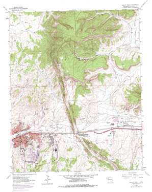
Gallup East Topo Map New Mexico
To zoom in, hover over the map of Gallup East
USGS Topo Quad 35108e6 - 1:24,000 scale
| Topo Map Name: | Gallup East |
| USGS Topo Quad ID: | 35108e6 |
| Print Size: | ca. 21 1/4" wide x 27" high |
| Southeast Coordinates: | 35.5° N latitude / 108.625° W longitude |
| Map Center Coordinates: | 35.5625° N latitude / 108.6875° W longitude |
| U.S. State: | NM |
| Filename: | o35108e6.jpg |
| Download Map JPG Image: | Gallup East topo map 1:24,000 scale |
| Map Type: | Topographic |
| Topo Series: | 7.5´ |
| Map Scale: | 1:24,000 |
| Source of Map Images: | United States Geological Survey (USGS) |
| Alternate Map Versions: |
Gallup East NM 1963, updated 1967 Download PDF Buy paper map Gallup East NM 1963, updated 1980 Download PDF Buy paper map Gallup East NM 1979, updated 1985 Download PDF Buy paper map Gallup East NM 2010 Download PDF Buy paper map Gallup East NM 2013 Download PDF Buy paper map |
1:24,000 Topo Quads surrounding Gallup East
> Back to 35108e1 at 1:100,000 scale
> Back to 35108a1 at 1:250,000 scale
> Back to U.S. Topo Maps home
Gallup East topo map: Gazetteer
Gallup East: Cliffs
White Cliffs elevation 2142m 7027′Gallup East: Mines
Chiaramonte Mine elevation 2016m 6614′Elkins Pit elevation 2075m 6807′
Enterprise Mine elevation 2032m 6666′
Fellin Prospect elevation 2002m 6568′
Gallup Fuel Company Mine elevation 2043m 6702′
Gibson Mine elevation 2099m 6886′
Golino Mine elevation 2005m 6578′
Grand Mission Mine elevation 2075m 6807′
Grenko Mine elevation 2075m 6807′
Heaton Mine elevation 2081m 6827′
Hillside Mine elevation 2023m 6637′
Hyde Mine elevation 2119m 6952′
J and P Mine elevation 2075m 6807′
Juliano Mine elevation 2064m 6771′
Kauzlarich Mine elevation 2022m 6633′
Keepers Mine elevation 1985m 6512′
Morelli Mine elevation 2025m 6643′
Myers Mine elevation 2075m 6807′
Nance Mine elevation 2075m 6807′
New Mutual Mine elevation 2075m 6807′
New Otero Mine elevation 1995m 6545′
Parron Mine elevation 2078m 6817′
Peacock Number Two Mine elevation 1996m 6548′
Peacock Numbers 2, 3 and 4 Mines elevation 2060m 6758′
Roberts Coal Mine elevation 2075m 6807′
Thacther Mine elevation 1996m 6548′
Thatcher Mine elevation 2080m 6824′
Weaver Mine elevation 2085m 6840′
William Coal Company Mine elevation 2076m 6811′
Gallup East: Parks
Babe Ruth Park elevation 1992m 6535′Gallup Historical Marker elevation 1985m 6512′
Gallup East: Populated Places
Gallup elevation 1985m 6512′Gibson (historical) elevation 2099m 6886′
Gibson (historical) elevation 2086m 6843′
Heaton (historical) elevation 2081m 6827′
Rehoboth elevation 2006m 6581′
Weaver (historical) elevation 2085m 6840′
Zuni elevation 2014m 6607′
Gallup East: Post Offices
Gallup Post Office elevation 1985m 6512′Gibson Post Office (historical) elevation 2086m 6843′
Rehoboth Post Office elevation 2006m 6581′
Gallup East: Streams
South Fork Puerco River elevation 2003m 6571′Gallup East: Summits
Crown Point elevation 2093m 6866′Gallup East: Valleys
Black Diamond Canyon elevation 1987m 6519′Catalpa Canyon elevation 1988m 6522′
Cliff Dwellers Canyon elevation 2074m 6804′
Heaton Canyon elevation 1989m 6525′
Padre Canyon elevation 2009m 6591′
Peretti Canyon elevation 1995m 6545′
Rocky Cliff Canyon elevation 1985m 6512′
Sunshine Canyon elevation 1985m 6512′
White Rock Canyon elevation 2070m 6791′
Gallup East: Wells
10023 Water Well elevation 2082m 6830′16K-303C Water Well elevation 2014m 6607′
Wingate 4 Well elevation 2014m 6607′
Wingate E Water Well elevation 2014m 6607′
Gallup East digital topo map on disk
Buy this Gallup East topo map showing relief, roads, GPS coordinates and other geographical features, as a high-resolution digital map file on DVD:


