Coyote Canyon Topo Map New Mexico
To zoom in, hover over the map of Coyote Canyon
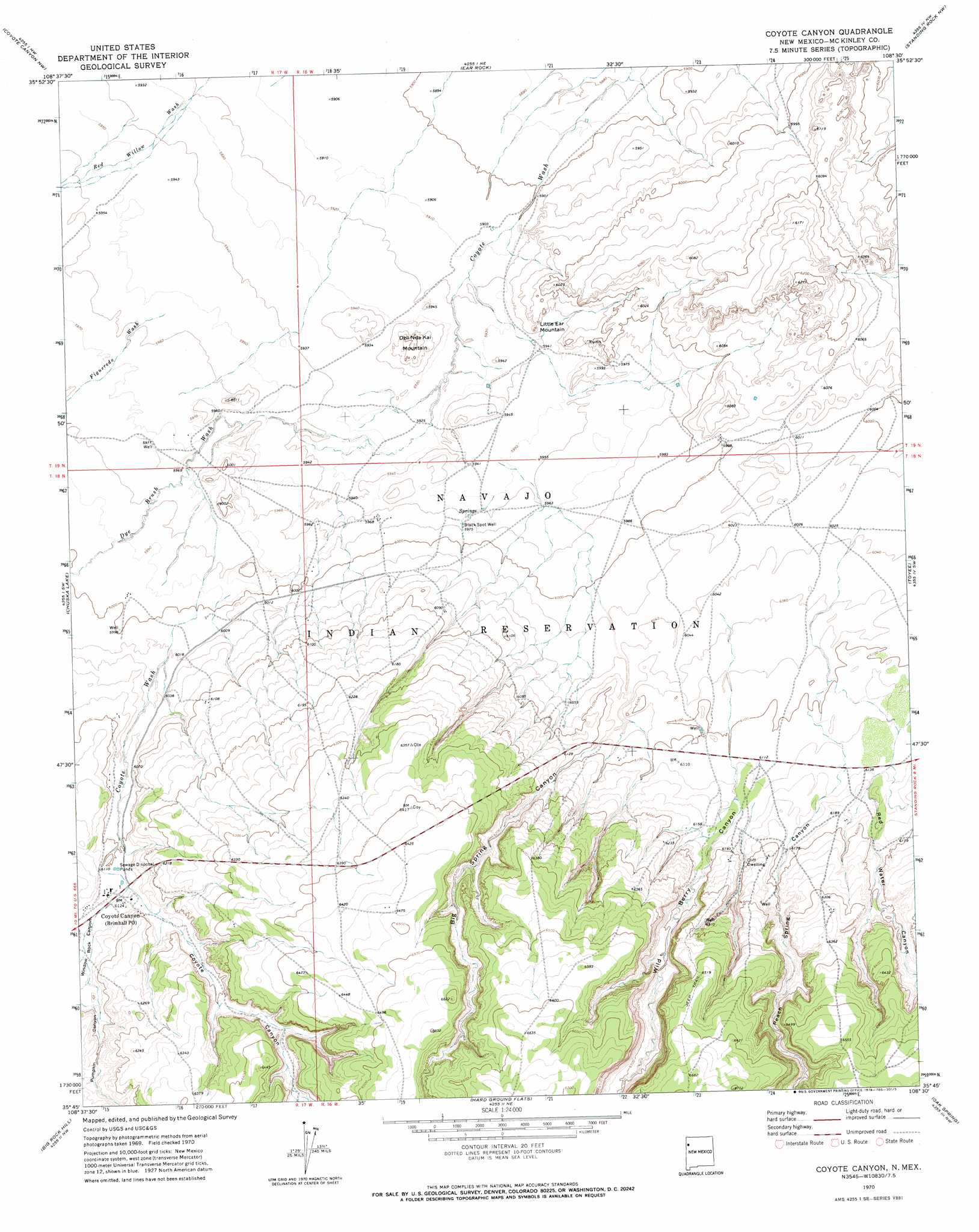
USGS Topo Quad 35108g5 - 1:24,000 scale
| Topo Map Name: | Coyote Canyon |
| USGS Topo Quad ID: | 35108g5 |
| Print Size: | ca. 21 1/4" wide x 27" high |
| Southeast Coordinates: | 35.75° N latitude / 108.5° W longitude |
| Map Center Coordinates: | 35.8125° N latitude / 108.5625° W longitude |
| U.S. State: | NM |
| Filename: | o35108g5.jpg |
| Download Map JPG Image: | Coyote Canyon topo map 1:24,000 scale |
| Map Type: | Topographic |
| Topo Series: | 7.5´ |
| Map Scale: | 1:24,000 |
| Source of Map Images: | United States Geological Survey (USGS) |
| Alternate Map Versions: |
Coyote Canyon NM 1970, updated 1974 Download PDF Buy paper map Coyote Canyon NM 2010 Download PDF Buy paper map Coyote Canyon NM 2013 Download PDF Buy paper map |
1:24,000 Topo Quads surrounding Coyote Canyon
Washington Pass |
Naschitti |
Grey Hill Spring |
The Pillar 2 Sw |
The Pillar 3 Se |
Chuska Peak |
Coyote Canyon Nw |
Ear Rock |
Standing Rock Nw |
Red Lake Well |
Tohatchi |
Chuska Lake |
Coyote Canyon |
Toyee |
Standing Rock |
Twin Lakes |
Big Rock Hill |
Hard Ground Flats |
Oak Spring |
Dalton Pass |
Gallup West |
Gallup East |
Church Rock |
Pinedale |
Mariano Lake |
> Back to 35108e1 at 1:100,000 scale
> Back to 35108a1 at 1:250,000 scale
> Back to U.S. Topo Maps home
Coyote Canyon topo map: Gazetteer
Coyote Canyon: Populated Places
Coyote Canyon elevation 1866m 6122′Coyote Canyon: Streams
Dye Brush Wash elevation 1814m 5951′Figueredo Wash elevation 1816m 5958′
Coyote Canyon: Summits
Dzil Nda Kai Mountain elevation 1830m 6003′Little Ear Mountain elevation 1824m 5984′
Coyote Canyon: Valleys
Big Spring Canyon elevation 1840m 6036′Coyote Canyon elevation 1865m 6118′
Peach Spring Canyon elevation 1865m 6118′
Pumpkin Canyon elevation 1884m 6181′
Red Water Canyon elevation 1872m 6141′
Wild Berry Canyon elevation 1859m 6099′
Window Rock Canyon elevation 1866m 6122′
Coyote Canyon: Wells
102-U8 Water Well elevation 1947m 6387′14M-25 Water Well elevation 1820m 5971′
14M-25A Water Well elevation 1821m 5974′
14T-324 Water Well elevation 1862m 6108′
14T-541 Water Well elevation 1848m 6062′
14T-544 Water Well elevation 1891m 6204′
14T-574 Water Well elevation 1947m 6387′
AN-1 Water Well elevation 1861m 6105′
AN-15 Water Well elevation 1953m 6407′
Black Spot Well elevation 1822m 5977′
Coyote Canyon digital topo map on disk
Buy this Coyote Canyon topo map showing relief, roads, GPS coordinates and other geographical features, as a high-resolution digital map file on DVD: