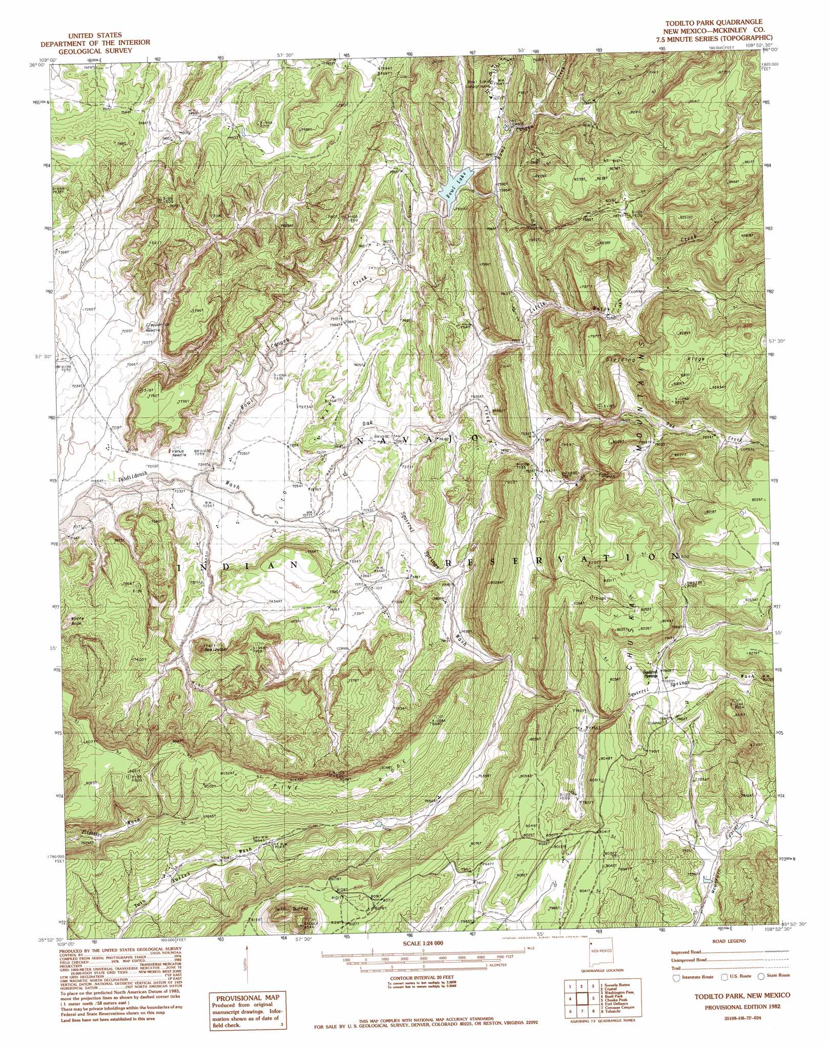
Todilto Park Topo Map New Mexico
To zoom in, hover over the map of Todilto Park
USGS Topo Quad 35108h8 - 1:24,000 scale
| Topo Map Name: | Todilto Park |
| USGS Topo Quad ID: | 35108h8 |
| Print Size: | ca. 21 1/4" wide x 27" high |
| Southeast Coordinates: | 35.875° N latitude / 108.875° W longitude |
| Map Center Coordinates: | 35.9375° N latitude / 108.9375° W longitude |
| U.S. State: | NM |
| Filename: | o35108h8.jpg |
| Download Map JPG Image: | Todilto Park topo map 1:24,000 scale |
| Map Type: | Topographic |
| Topo Series: | 7.5´ |
| Map Scale: | 1:24,000 |
| Source of Map Images: | United States Geological Survey (USGS) |
| Alternate Map Versions: |
Todilto Park NM 1982, updated 1983 Download PDF Buy paper map Todilto Park NM 2010 Download PDF Buy paper map Todilto Park NM 2013 Download PDF Buy paper map Todilto Park NM 2017 Download PDF Buy paper map |
1:24,000 Topo Quads surrounding Todilto Park
Lower Wheatfields |
Upper Wheatfields |
Toadlena |
Two Grey Hills |
Sheep Springs |
White Clay |
Sonsela Buttes |
Crystal |
Washington Pass |
Naschitti |
Sawmill |
Buell Park |
Todilto Park |
Chuska Peak |
Coyote Canyon Nw |
Piney Hill |
Fort Defiance |
Crevasse Canyon |
Tohatchi |
Chuska Lake |
West Of Window Rock |
Window Rock |
Tse Bonita School |
Twin Lakes |
Big Rock Hill |
> Back to 35108e1 at 1:100,000 scale
> Back to 35108a1 at 1:250,000 scale
> Back to U.S. Topo Maps home
Todilto Park topo map: Gazetteer
Todilto Park: Arches
The Great Eye elevation 2325m 7627′Todilto Park: Bars
White Rock elevation 2261m 7417′Todilto Park: Dams
Asaayi Dam elevation 2281m 7483′Todilto Park: Lakes
Bowl Lake elevation 2290m 7513′Todilto Park: Pillars
Cleopatras Needle elevation 2233m 7326′Venus Needle elevation 2209m 7247′
Todilto Park: Ridges
Dividing Ridge elevation 2507m 8225′Pine Ridge elevation 2463m 8080′
Todilto Park: Springs
Squirrel Springs elevation 2390m 7841′Todilto Park: Streams
Bowl Canyon Creek elevation 2202m 7224′Little Water Creek elevation 2263m 7424′
Oak Creek elevation 2201m 7221′
Squirrel Springs Wash elevation 2201m 7221′
Todilto Park: Summits
Beelzebub elevation 2350m 7709′Twin Buttes elevation 2570m 8431′
Todilto Park: Valleys
Windy Canyon elevation 2300m 7545′Todilto Park digital topo map on disk
Buy this Todilto Park topo map showing relief, roads, GPS coordinates and other geographical features, as a high-resolution digital map file on DVD: