Buell Park Topo Map Arizona
To zoom in, hover over the map of Buell Park
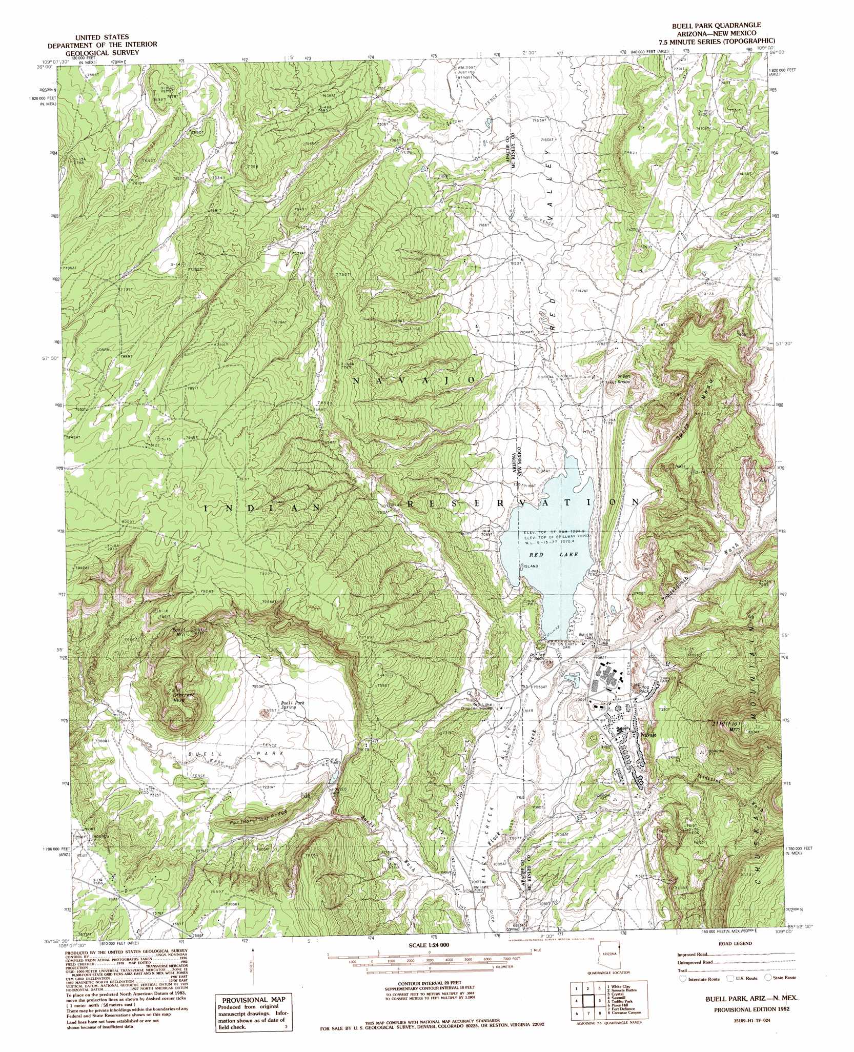
USGS Topo Quad 35109h1 - 1:24,000 scale
| Topo Map Name: | Buell Park |
| USGS Topo Quad ID: | 35109h1 |
| Print Size: | ca. 21 1/4" wide x 27" high |
| Southeast Coordinates: | 35.875° N latitude / 109° W longitude |
| Map Center Coordinates: | 35.9375° N latitude / 109.0625° W longitude |
| U.S. States: | AZ, NM |
| Filename: | o35109h1.jpg |
| Download Map JPG Image: | Buell Park topo map 1:24,000 scale |
| Map Type: | Topographic |
| Topo Series: | 7.5´ |
| Map Scale: | 1:24,000 |
| Source of Map Images: | United States Geological Survey (USGS) |
| Alternate Map Versions: |
Zith-Tusayan Butte 1 NE AZ 1955, updated 1958 Download PDF Buy paper map Buell Park AZ 1982, updated 1983 Download PDF Buy paper map Buell Park AZ 2011 Download PDF Buy paper map Buell Park AZ 2011 Download PDF Buy paper map Buell Park AZ 2014 Download PDF Buy paper map |
1:24,000 Topo Quads surrounding Buell Park
Mummy Cave Ruins |
Lower Wheatfields |
Upper Wheatfields |
Toadlena |
Two Grey Hills |
Spider Rock |
White Clay |
Sonsela Buttes |
Crystal |
Washington Pass |
White Rock Wash |
Sawmill |
Buell Park |
Todilto Park |
Chuska Peak |
Oak Creek Mountain |
Piney Hill |
Fort Defiance |
Crevasse Canyon |
Tohatchi |
East Of Kinlichee |
West Of Window Rock |
Window Rock |
Tse Bonita School |
Twin Lakes |
> Back to 35109e1 at 1:100,000 scale
> Back to 35108a1 at 1:250,000 scale
> Back to U.S. Topo Maps home
Buell Park topo map: Gazetteer
Buell Park: Dams
Red Lake Dam elevation 2159m 7083′Red Lake Dam elevation 2156m 7073′
Buell Park: Flats
Buell Park elevation 2209m 7247′Buell Park: Pillars
Frog Rock elevation 2206m 7237′Outlet Neck elevation 2166m 7106′
Buell Park: Populated Places
Navajo elevation 2168m 7112′Buell Park: Reservoirs
Red Lake elevation 2156m 7073′Red Lake elevation 2156m 7073′
Buell Park: Ridges
Outlet Neck elevation 2193m 7194′Peridot Ridge elevation 2271m 7450′
Buell Park: Streams
Tohdildonih Wash elevation 2148m 7047′Zilditloi Wash elevation 2168m 7112′
Buell Park: Summits
Buell Mountain elevation 2466m 8090′Green Knobs elevation 2210m 7250′
Split Mesa elevation 2399m 7870′
Sterrett Mesa elevation 2406m 7893′
Zilditloi Mountain elevation 2604m 8543′
Buell Park: Valleys
Red Valley elevation 2159m 7083′Red Valley elevation 2159m 7083′
Buell Park: Wells
Justins Windmill elevation 2196m 7204′Buell Park digital topo map on disk
Buy this Buell Park topo map showing relief, roads, GPS coordinates and other geographical features, as a high-resolution digital map file on DVD: