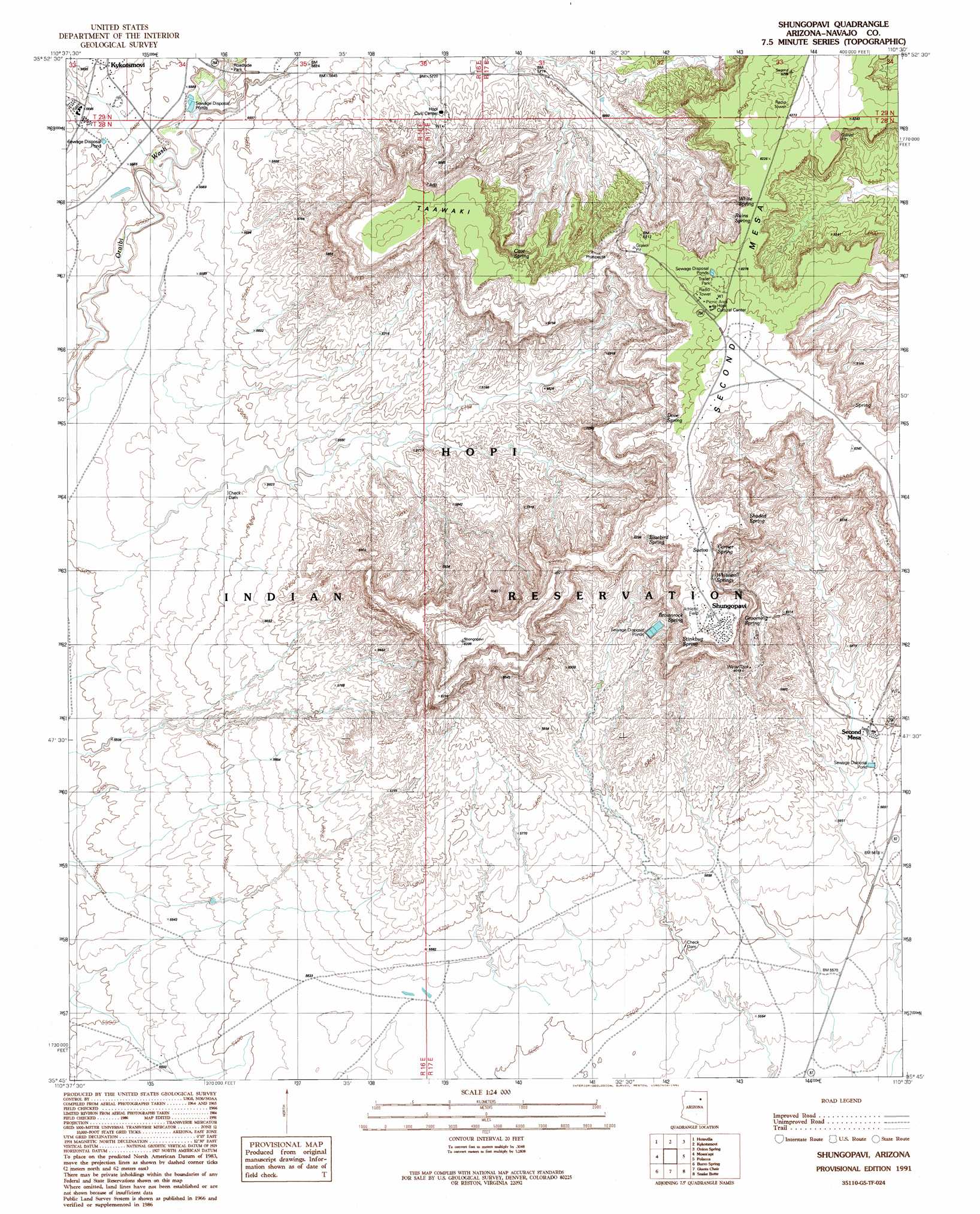
Shongopovi Topo Map Arizona
To zoom in, hover over the map of Shongopovi
USGS Topo Quad 35110g5 - 1:24,000 scale
| Topo Map Name: | Shongopovi |
| USGS Topo Quad ID: | 35110g5 |
| Print Size: | ca. 21 1/4" wide x 27" high |
| Southeast Coordinates: | 35.75° N latitude / 110.5° W longitude |
| Map Center Coordinates: | 35.8125° N latitude / 110.5625° W longitude |
| U.S. State: | AZ |
| Filename: | o35110g5.jpg |
| Download Map JPG Image: | Shongopovi topo map 1:24,000 scale |
| Map Type: | Topographic |
| Topo Series: | 7.5´ |
| Map Scale: | 1:24,000 |
| Source of Map Images: | United States Geological Survey (USGS) |
| Alternate Map Versions: |
Shungopavi AZ 1991, updated 1991 Download PDF Buy paper map Shungopavi AZ 2011 Download PDF Buy paper map Shungopavi AZ 2014 Download PDF Buy paper map |
1:24,000 Topo Quads surrounding Shongopovi
Bat Spring |
Rocky Ridge Sw |
Rocky Ridge Se |
Hard Rocks |
Little Black Spot Mountain |
Howell Mesa |
Hotevilla |
Oraibi |
Onion Spring |
Wepo Village |
Padilla Mesa |
Mount Beautiful |
Shongopovi |
Polacca |
Sun Altar |
Garces Mesas Ne |
Burro Spring |
Giants Chair |
Snake Butte |
Star Mountain |
Garces Mesas Se |
Tovar Mesa West |
Tovar Mesa East |
Egloffstein Butte |
Hauke Mesa |
> Back to 35110e1 at 1:100,000 scale
> Back to 35110a1 at 1:250,000 scale
> Back to U.S. Topo Maps home
Shongopovi topo map: Gazetteer
Shongopovi: Areas
Tusayan elevation 1704m 5590′Shongopovi: Parks
Hopi Tribe Picnic Area elevation 1689m 5541′Shongopovi: Populated Places
Kykotsmovi Village elevation 1732m 5682′Old Shongopavi (historical) elevation 1832m 6010′
Second Mesa elevation 1738m 5702′
Shongopovi elevation 1934m 6345′
Shungopavi elevation 1944m 6377′
Shongopovi: Post Offices
Shungapavy Post Office (historical) elevation 1934m 6345′Shongopovi: Springs
Bluebird Spring elevation 1910m 6266′Brownrock Spring elevation 1920m 6299′
Cave Spring elevation 1884m 6181′
Corner Spring elevation 1906m 6253′
Dove Spring elevation 1892m 6207′
Grooming Spring elevation 1885m 6184′
Ruins Spring elevation 1849m 6066′
Shaded Spring elevation 1917m 6289′
Shungopavi Spring elevation 1938m 6358′
Stinkbug Spring elevation 1899m 6230′
Suviva elevation 1931m 6335′
White Spring elevation 1870m 6135′
Whitewall Springs elevation 1903m 6243′
Shongopovi: Summits
Taawaki elevation 1899m 6230′Shongopovi digital topo map on disk
Buy this Shongopovi topo map showing relief, roads, GPS coordinates and other geographical features, as a high-resolution digital map file on DVD: