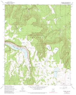
Ashurst Lake Topo Map Arizona
To zoom in, hover over the map of Ashurst Lake
USGS Topo Quad 35111a4 - 1:24,000 scale
| Topo Map Name: | Ashurst Lake |
| USGS Topo Quad ID: | 35111a4 |
| Print Size: | ca. 21 1/4" wide x 27" high |
| Southeast Coordinates: | 35° N latitude / 111.375° W longitude |
| Map Center Coordinates: | 35.0625° N latitude / 111.4375° W longitude |
| U.S. State: | AZ |
| Filename: | o35111a4.jpg |
| Download Map JPG Image: | Ashurst Lake topo map 1:24,000 scale |
| Map Type: | Topographic |
| Topo Series: | 7.5´ |
| Map Scale: | 1:24,000 |
| Source of Map Images: | United States Geological Survey (USGS) |
| Alternate Map Versions: |
Ashurst Lake AZ 1962, updated 1964 Download PDF Buy paper map Ashurst Lake AZ 1962, updated 1974 Download PDF Buy paper map Ashurst Lake AZ 1962, updated 1976 Download PDF Buy paper map Ashurst Lake AZ 1962, updated 1984 Download PDF Buy paper map Ashurst Lake AZ 1962, updated 1984 Download PDF Buy paper map Ashurst Lake AZ 2011 Download PDF Buy paper map Ashurst Lake AZ 2014 Download PDF Buy paper map |
| FStopo: | US Forest Service topo Ashurst Lake is available: Download FStopo PDF Download FStopo TIF |
1:24,000 Topo Quads surrounding Ashurst Lake
> Back to 35111a1 at 1:100,000 scale
> Back to 35110a1 at 1:250,000 scale
> Back to U.S. Topo Maps home
Ashurst Lake topo map: Gazetteer
Ashurst Lake: Dams
Ashurst Lake Dam elevation 2171m 7122′Coconino Dam elevation 2172m 7125′
Ashurst Lake: Lakes
Als Lake elevation 2165m 7103′Ashurst Lake elevation 2171m 7122′
Deep Lake elevation 2130m 6988′
Horse Lake elevation 2177m 7142′
Indian Lake elevation 2169m 7116′
Pickett Lake elevation 2164m 7099′
Post Lake elevation 2164m 7099′
Potato Lake elevation 2156m 7073′
Youngs Lake elevation 2181m 7155′
Ashurst Lake: Parks
Forked Pine Picnic Area elevation 2172m 7125′Ashurst Lake: Reservoirs
Adams Tank elevation 2019m 6624′Als Lake Tank elevation 2165m 7103′
Antelope Tank elevation 2165m 7103′
Ashurst Tank elevation 2182m 7158′
Breezy Number One Tank elevation 2164m 7099′
Cabin Tank elevation 2010m 6594′
Canyon Tank elevation 2073m 6801′
Coconino Lake elevation 2172m 7125′
Deep Lake Tank elevation 2130m 6988′
Dunn Tank elevation 1975m 6479′
Foster Tank elevation 1989m 6525′
Horse Lake Tank elevation 2177m 7142′
Horse Tank elevation 2168m 7112′
Indian Lake Tank elevation 2168m 7112′
Indian Lake Tank elevation 2171m 7122′
Johns Tank elevation 2144m 7034′
Juniper Tank elevation 1997m 6551′
Mormon Canyon Tank One elevation 2147m 7043′
Mormon Canyon Tank Two elevation 1956m 6417′
Otteson Tank elevation 2094m 6870′
Potato Lake Tank elevation 2159m 7083′
Railroad Tank elevation 2109m 6919′
Railroad Trick Tank elevation 2096m 6876′
Red Tank elevation 2008m 6587′
Rye Tank elevation 1977m 6486′
Snag Tank elevation 2097m 6879′
Youngs Spring Tank elevation 2153m 7063′
Youngs Tank elevation 2181m 7155′
Ashurst Lake: Springs
Ashurst Spring elevation 2154m 7066′Elk Spring elevation 2135m 7004′
Youngs Spring elevation 2159m 7083′
Ashurst Lake: Streams
Ashurst Run elevation 2171m 7122′Ashurst Lake: Summits
Anderson Mesa elevation 2154m 7066′Ashurst Lake: Valleys
Newman Canyon elevation 2078m 6817′Ashurst Lake digital topo map on disk
Buy this Ashurst Lake topo map showing relief, roads, GPS coordinates and other geographical features, as a high-resolution digital map file on DVD:


