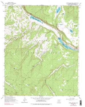
Lower Lake Mary Topo Map Arizona
To zoom in, hover over the map of Lower Lake Mary
USGS Topo Quad 35111a5 - 1:24,000 scale
| Topo Map Name: | Lower Lake Mary |
| USGS Topo Quad ID: | 35111a5 |
| Print Size: | ca. 21 1/4" wide x 27" high |
| Southeast Coordinates: | 35° N latitude / 111.5° W longitude |
| Map Center Coordinates: | 35.0625° N latitude / 111.5625° W longitude |
| U.S. State: | AZ |
| Filename: | o35111a5.jpg |
| Download Map JPG Image: | Lower Lake Mary topo map 1:24,000 scale |
| Map Type: | Topographic |
| Topo Series: | 7.5´ |
| Map Scale: | 1:24,000 |
| Source of Map Images: | United States Geological Survey (USGS) |
| Alternate Map Versions: |
Lower Lake Mary AZ 1962, updated 1964 Download PDF Buy paper map Lower Lake Mary AZ 1962, updated 1973 Download PDF Buy paper map Lower Lake Mary AZ 1962, updated 1976 Download PDF Buy paper map Lower Lake Mary AZ 1962, updated 1990 Download PDF Buy paper map Lower Lake Mary AZ 2011 Download PDF Buy paper map Lower Lake Mary AZ 2014 Download PDF Buy paper map |
| FStopo: | US Forest Service topo Lower Lake Mary is available: Download FStopo PDF Download FStopo TIF |
1:24,000 Topo Quads surrounding Lower Lake Mary
> Back to 35111a1 at 1:100,000 scale
> Back to 35110a1 at 1:250,000 scale
> Back to U.S. Topo Maps home
Lower Lake Mary topo map: Gazetteer
Lower Lake Mary: Dams
Lower Lake Mary Dam elevation 2075m 6807′Upper Lake Mary Dam elevation 2078m 6817′
Lower Lake Mary: Flats
Coulter Park elevation 2235m 7332′Elk Park Meadows elevation 2116m 6942′
Lake Mary Meadows elevation 2097m 6879′
Lower Lake Mary: Lakes
Fisher and Fry Lake elevation 2201m 7221′Lake Number One elevation 2175m 7135′
Little Dry Lake elevation 2196m 7204′
Marshall Lake elevation 2176m 7139′
Prime Lake elevation 2200m 7217′
Vail Lake elevation 2198m 7211′
Lower Lake Mary: Reservoirs
Bonita Tank elevation 2254m 7395′Cañada Granda Tank elevation 2176m 7139′
Charco Tank elevation 2276m 7467′
Corner Tank elevation 2240m 7349′
Double Tank elevation 2123m 6965′
Forest Service Tank elevation 2243m 7358′
Hey Dog Tank elevation 2165m 7103′
Hold Up Tank elevation 2182m 7158′
Howard Tank elevation 2118m 6948′
Hoxworth Tank elevation 2136m 7007′
Joeys Tank elevation 2177m 7142′
Johnneys Tank elevation 2158m 7080′
Lagunita Tank elevation 2207m 7240′
Little Dry Lake Tank elevation 2196m 7204′
Lost Tank elevation 2202m 7224′
Lower Lake Mary elevation 2075m 6807′
Lower Tank elevation 2176m 7139′
Marshall Mesa Tank elevation 2133m 6998′
Mount Lion Tank elevation 2268m 7440′
Mustang Park Tank elevation 2208m 7244′
Nameless Tank elevation 2103m 6899′
Natural Tank elevation 2121m 6958′
Newman Tank elevation 2110m 6922′
Peterson Seepage elevation 2239m 7345′
Pit Number Two Tank elevation 2123m 6965′
Pit One Tank elevation 2122m 6961′
Roadbed Tank elevation 2084m 6837′
Rocky Tank elevation 2123m 6965′
Sinkhole Tank elevation 2148m 7047′
Statler Tank elevation 2092m 6863′
Stump Tank elevation 2102m 6896′
Upper Lake Mary elevation 2078m 6817′
Vail Lake Tank elevation 2198m 7211′
Westec Tank elevation 2094m 6870′
Wild Horse Tank elevation 2158m 7080′
Lower Lake Mary: Springs
Babbit Spring elevation 2103m 6899′Hoxworth Springs elevation 2144m 7034′
Thomas Spring elevation 2238m 7342′
Lower Lake Mary: Summits
Coulter Hill elevation 2349m 7706′Lower Lake Mary: Valleys
Howard Draw elevation 2074m 6804′Priest Draw elevation 2083m 6833′
Lower Lake Mary: Wells
Clark Well elevation 2105m 6906′JAO Well elevation 2113m 6932′
Lower Lake Mary digital topo map on disk
Buy this Lower Lake Mary topo map showing relief, roads, GPS coordinates and other geographical features, as a high-resolution digital map file on DVD:


