Wing Mountain Topo Map Arizona
To zoom in, hover over the map of Wing Mountain
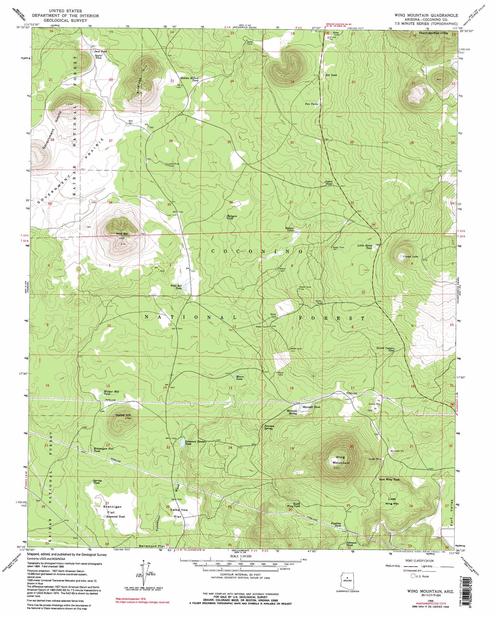
USGS Topo Quad 35111c7 - 1:24,000 scale
| Topo Map Name: | Wing Mountain |
| USGS Topo Quad ID: | 35111c7 |
| Print Size: | ca. 21 1/4" wide x 27" high |
| Southeast Coordinates: | 35.25° N latitude / 111.75° W longitude |
| Map Center Coordinates: | 35.3125° N latitude / 111.8125° W longitude |
| U.S. State: | AZ |
| Filename: | o35111c7.jpg |
| Download Map JPG Image: | Wing Mountain topo map 1:24,000 scale |
| Map Type: | Topographic |
| Topo Series: | 7.5´ |
| Map Scale: | 1:24,000 |
| Source of Map Images: | United States Geological Survey (USGS) |
| Alternate Map Versions: |
Wing Mountain AZ 1966, updated 1968 Download PDF Buy paper map Wing Mountain AZ 1966, updated 1978 Download PDF Buy paper map Wing Mountain AZ 1966, updated 1991 Download PDF Buy paper map Wing Mountain AZ 1966, updated 1991 Download PDF Buy paper map Wing Mountain AZ 2012 Download PDF Buy paper map Wing Mountain AZ 2014 Download PDF Buy paper map |
| FStopo: | US Forest Service topo Wing Mountain is available: Download FStopo PDF Download FStopo TIF |
1:24,000 Topo Quads surrounding Wing Mountain
Hobble Tank |
Ebert Mountain |
Chapel Mountain |
S P Mountain |
East Of S P Mountain |
Squaw Mountain |
Moritz Ridge |
Kendrick Peak |
White Horse Hills |
O'Leary Peak |
Sitgreaves Mountain |
Parks |
Wing Mountain |
Humphreys Peak |
Sunset Crater West |
Davenport Hill |
Garland Prairie |
Bellemont |
Flagstaff West |
Flagstaff East |
White Horse Lake |
Sycamore Point |
Dutton Hill |
Mountainaire |
Lower Lake Mary |
> Back to 35111a1 at 1:100,000 scale
> Back to 35110a1 at 1:250,000 scale
> Back to U.S. Topo Maps home
Wing Mountain topo map: Gazetteer
Wing Mountain: Flats
Brannigan Flat elevation 2198m 7211′Camp Two Flat elevation 2201m 7221′
Wing Mountain: Forests
Fort Valley Experimental Forest elevation 2294m 7526′Wing Mountain: Lakes
Crater Lake elevation 2490m 8169′Wing Mountain: Reservoirs
Ackel Tank elevation 2270m 7447′Arkansas Tank elevation 2335m 7660′
Aspen Tank elevation 2408m 7900′
Badger Tank elevation 2373m 7785′
Basalt Tank elevation 2311m 7582′
Bill Tank elevation 2328m 7637′
Bradley Tank elevation 2378m 7801′
Brannigan Flat Tank elevation 2224m 7296′
Bunk Tank elevation 2503m 8211′
Calf Trick Tank elevation 2298m 7539′
Camp Number Two Tank elevation 2200m 7217′
Camp Z Tank elevation 2199m 7214′
Cat Trick Tank elevation 2353m 7719′
Coop Tank elevation 2439m 8001′
Deer Trick Tank elevation 2423m 7949′
Dent Tank elevation 2335m 7660′
Drowned Timber Tank elevation 2228m 7309′
East Wing Tank elevation 2319m 7608′
Elk Tank elevation 2439m 8001′
Gas Tank elevation 2261m 7417′
Grand Canyon Tank elevation 2352m 7716′
Hidden Hollow Tank elevation 2365m 7759′
Hidden Tank (historical) elevation 2286m 7500′
Hockderfer Trick Tank elevation 2698m 8851′
Holding Pasture Tank elevation 2297m 7536′
Horchderffer Tank elevation 2613m 8572′
Johnson Tank elevation 2360m 7742′
Little Horse Tank elevation 2431m 7975′
Little Wing Tank elevation 2263m 7424′
Malpais Tank elevation 2341m 7680′
Maxwell Tank elevation 2302m 7552′
Michelbach Tank elevation 2490m 8169′
Moore Tank elevation 2266m 7434′
One Eight Tank elevation 2403m 7883′
Orchard Trick Tank elevation 2347m 7700′
Pine Trick Tank elevation 2317m 7601′
Pipeline Tank elevation 2368m 7769′
Pulp Tank elevation 2211m 7253′
Raymond Tank elevation 2195m 7201′
Sayre Tank elevation 2335m 7660′
South Crater Tank elevation 2406m 7893′
South Wing Tank elevation 2352m 7716′
Spring Tank elevation 2201m 7221′
Stagecoach Tank elevation 2379m 7805′
Taylor Tank elevation 2328m 7637′
Taylor Tank elevation 2325m 7627′
Thompson Tank elevation 2220m 7283′
Twin Tanks elevation 2427m 7962′
Two Tanks elevation 2426m 7959′
Walker Hill Tank elevation 2243m 7358′
Walker Tank elevation 2243m 7358′
Water Haul Tank elevation 2409m 7903′
West Wing Tank elevation 2304m 7559′
Wild Bill Tank elevation 2303m 7555′
Wing Mountain: Springs
Maxwell Spring elevation 2305m 7562′Pearson Spring elevation 2298m 7539′
Wing Mountain: Streams
Volunteer Wash elevation 2186m 7171′Wing Mountain: Summits
Antelope Hill elevation 2509m 8231′Government Knolls elevation 2351m 7713′
Little Wing Mountain elevation 2348m 7703′
Walker Hill elevation 2344m 7690′
Wild Bill Hill elevation 2496m 8188′
Wing Mountain elevation 2613m 8572′
Wing Mountain digital topo map on disk
Buy this Wing Mountain topo map showing relief, roads, GPS coordinates and other geographical features, as a high-resolution digital map file on DVD: