Moritz Ridge Topo Map Arizona
To zoom in, hover over the map of Moritz Ridge
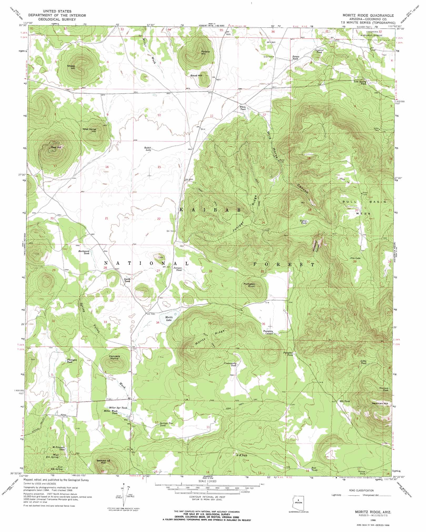
USGS Topo Quad 35111d8 - 1:24,000 scale
| Topo Map Name: | Moritz Ridge |
| USGS Topo Quad ID: | 35111d8 |
| Print Size: | ca. 21 1/4" wide x 27" high |
| Southeast Coordinates: | 35.375° N latitude / 111.875° W longitude |
| Map Center Coordinates: | 35.4375° N latitude / 111.9375° W longitude |
| U.S. State: | AZ |
| Filename: | o35111d8.jpg |
| Download Map JPG Image: | Moritz Ridge topo map 1:24,000 scale |
| Map Type: | Topographic |
| Topo Series: | 7.5´ |
| Map Scale: | 1:24,000 |
| Source of Map Images: | United States Geological Survey (USGS) |
| Alternate Map Versions: |
Moritz Ridge AZ 1966, updated 1968 Download PDF Buy paper map Moritz Ridge AZ 1966, updated 1968 Download PDF Buy paper map Moritz Ridge AZ 2012 Download PDF Buy paper map Moritz Ridge AZ 2014 Download PDF Buy paper map |
| FStopo: | US Forest Service topo Moritz Ridge is available: Download FStopo PDF Download FStopo TIF |
1:24,000 Topo Quads surrounding Moritz Ridge
Valle Tank |
Molly Ann Draw |
Dog Knobs |
Lockwood Canyon |
Additional Hill |
Howard Lake |
Hobble Tank |
Ebert Mountain |
Chapel Mountain |
S P Mountain |
Howard Mesa |
Squaw Mountain |
Moritz Ridge |
Kendrick Peak |
White Horse Hills |
Williams North |
Sitgreaves Mountain |
Parks |
Wing Mountain |
Humphreys Peak |
Williams South |
Davenport Hill |
Garland Prairie |
Bellemont |
Flagstaff West |
> Back to 35111a1 at 1:100,000 scale
> Back to 35110a1 at 1:250,000 scale
> Back to U.S. Topo Maps home
Moritz Ridge topo map: Gazetteer
Moritz Ridge: Lakes
Dry Lake elevation 2412m 7913′Fay Lake elevation 2153m 7063′
Moritz Lake elevation 2164m 7099′
Raymond Lake elevation 2165m 7103′
Moritz Ridge: Populated Places
Pumpkin Center elevation 2206m 7237′Moritz Ridge: Reservoirs
Backward Tank elevation 2125m 6971′BR Tank elevation 2244m 7362′
Cable Guzzler elevation 2164m 7099′
Caporal Tank elevation 2088m 6850′
Community Tank elevation 2212m 7257′
Drip Tank elevation 2085m 6840′
Elk Tank elevation 2278m 7473′
Flanigan Tank elevation 2151m 7057′
Horse Tank elevation 2178m 7145′
Juniper Tank elevation 2158m 7080′
Little Tank elevation 2354m 7723′
Lost Spring Tank elevation 2124m 6968′
Lost Spring Water Tank elevation 2189m 7181′
Marlar Tank elevation 2234m 7329′
Miller Spring Tank elevation 2176m 7139′
Miller Wash Tank elevation 2177m 7142′
Newman Tank elevation 2424m 7952′
Perreault Tank elevation 2205m 7234′
Potato Tank elevation 2087m 6847′
Pumpkin Tank elevation 2229m 7312′
Rabbit Lake elevation 2108m 6916′
Red Tank elevation 2261m 7417′
Section Ten Tank elevation 2182m 7158′
Serape Tank elevation 2299m 7542′
Smith Tank elevation 2134m 7001′
Spud Tank elevation 2090m 6856′
Tiptop Tank elevation 2396m 7860′
Turkey Tank elevation 2344m 7690′
White Tank elevation 2121m 6958′
Wildlife Guzzler elevation 2254m 7395′
Wildlife Guzzler elevation 2216m 7270′
W-Triangle Tank elevation 2188m 7178′
Moritz Ridge: Ridges
Juniper Ridge elevation 2300m 7545′Moritz Ridge: Springs
East Elk Spring elevation 2218m 7276′Lost Spring elevation 2198m 7211′
West Elk Spring elevation 2195m 7201′
Moritz Ridge: Summits
Bull Basin Mesa elevation 2435m 7988′Conners Hump elevation 2234m 7329′
Moritz Ridge elevation 2300m 7545′
Newman Hill elevation 2589m 8494′
Newman Hill elevation 2588m 8490′
Potato Hill elevation 2210m 7250′
Pumpkin Knoll elevation 2283m 7490′
Red Hill elevation 2362m 7749′
Section Sixteen Hill elevation 2337m 7667′
Sheep Hill elevation 2214m 7263′
Spud Hill elevation 2155m 7070′
Wild Horse Hill elevation 2207m 7240′
Moritz Ridge: Valleys
Horsethief Canyon elevation 2256m 7401′Spring Valley elevation 2189m 7181′
Wild Horse Canyon elevation 2129m 6984′
Moritz Ridge digital topo map on disk
Buy this Moritz Ridge topo map showing relief, roads, GPS coordinates and other geographical features, as a high-resolution digital map file on DVD: