Wupatki Sw Topo Map Arizona
To zoom in, hover over the map of Wupatki Sw
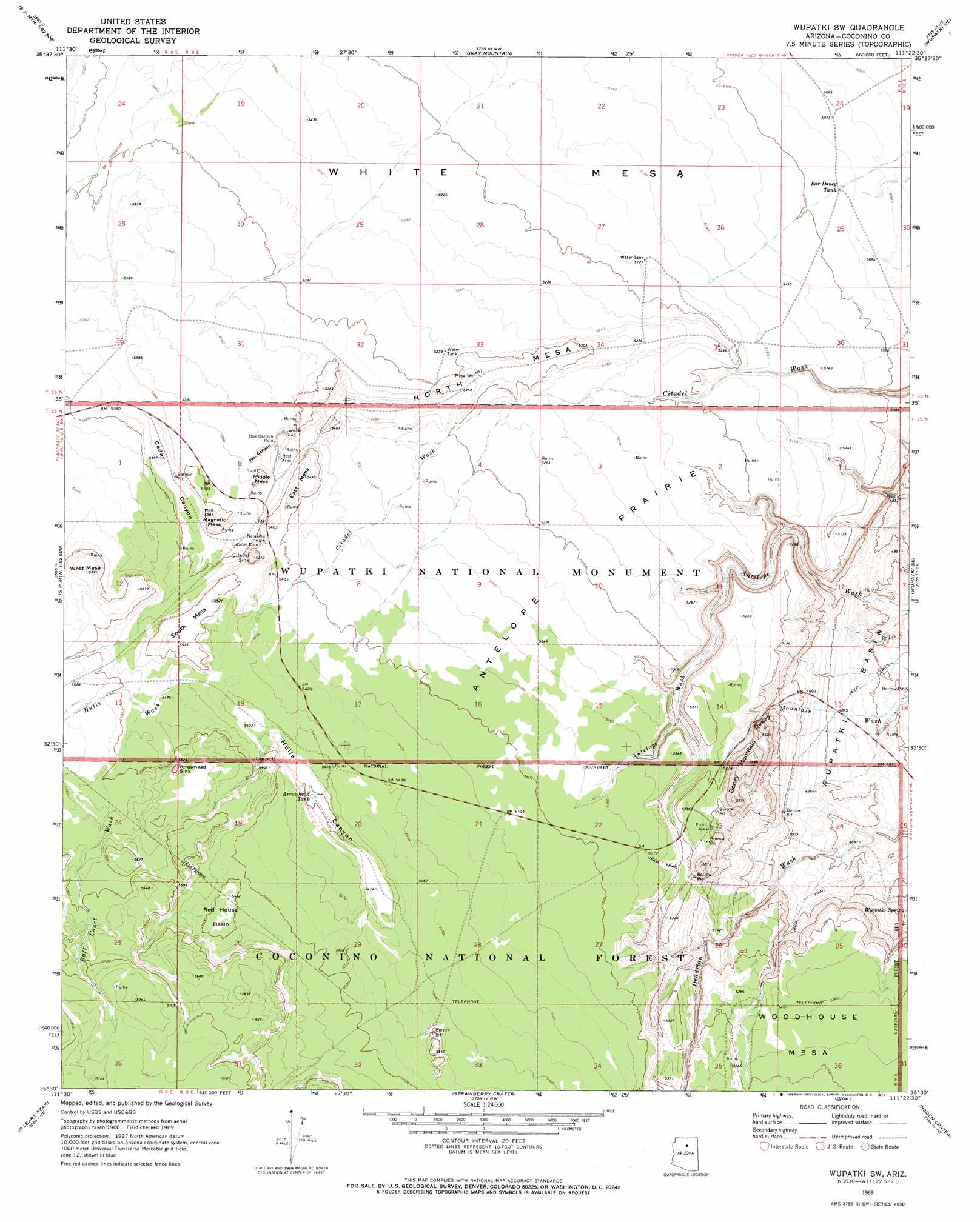
USGS Topo Quad 35111e4 - 1:24,000 scale
| Topo Map Name: | Wupatki Sw |
| USGS Topo Quad ID: | 35111e4 |
| Print Size: | ca. 21 1/4" wide x 27" high |
| Southeast Coordinates: | 35.5° N latitude / 111.375° W longitude |
| Map Center Coordinates: | 35.5625° N latitude / 111.4375° W longitude |
| U.S. State: | AZ |
| Filename: | o35111e4.jpg |
| Download Map JPG Image: | Wupatki Sw topo map 1:24,000 scale |
| Map Type: | Topographic |
| Topo Series: | 7.5´ |
| Map Scale: | 1:24,000 |
| Source of Map Images: | United States Geological Survey (USGS) |
| Alternate Map Versions: |
Wupatki SW AZ 1969, updated 1972 Download PDF Buy paper map Wupatki SW AZ 2011 Download PDF Buy paper map Wupatki SW AZ 2014 Download PDF Buy paper map |
| FStopo: | US Forest Service topo Wupatki SW is available: Download FStopo PDF Download FStopo TIF |
1:24,000 Topo Quads surrounding Wupatki Sw
Willows Camp |
Coconino Point Se |
Cameron South |
Cameron Se |
The Landmark |
Additional Hill |
Campbell Francis Wash |
Gray Mountain |
Wupatki Ne |
Badger Spring |
S P Mountain |
East Of S P Mountain |
Wupatki Sw |
Wupatki Se |
Standing Rocks |
White Horse Hills |
O'Leary Peak |
Strawberry Crater |
Roden Crater |
Grand Falls |
Humphreys Peak |
Sunset Crater West |
Sunset Crater East |
Merriam Crater |
Grand Falls Sw |
> Back to 35111e1 at 1:100,000 scale
> Back to 35110a1 at 1:250,000 scale
> Back to U.S. Topo Maps home
Wupatki Sw topo map: Gazetteer
Wupatki Sw: Basins
Arrowhead Sink elevation 1684m 5524′Citadel Sink elevation 1624m 5328′
Red House Basin elevation 1674m 5492′
Wupatki Sw: Cliffs
Doney Cliffs elevation 1544m 5065′Wupatki Sw: Flats
Antelope Prairie elevation 1618m 5308′Wupatki Sw: Reservoirs
Arrowhead Tank elevation 1646m 5400′Bar Doney Tank elevation 1549m 5082′
Wupatki Sw: Springs
Wupatki Spring elevation 1488m 4881′Wupatki Sw: Streams
Ball Court Wash elevation 1668m 5472′Hulls Wash elevation 1665m 5462′
Wupatki Sw: Summits
Doney Mountain elevation 1692m 5551′East Mesa elevation 1663m 5456′
Magnetic Mesa elevation 1667m 5469′
Middle Mesa elevation 1656m 5433′
North Mesa elevation 1625m 5331′
South Mesa elevation 1683m 5521′
West Mesa elevation 1700m 5577′
White Mesa elevation 1575m 5167′
Woodhouse Mesa elevation 1613m 5291′
Wupatki Sw: Valleys
Box Canyon elevation 1627m 5337′Cedar Canyon elevation 1637m 5370′
Hulls Canyon elevation 1660m 5446′
Wupatki Sw: Wells
Mesa Well elevation 1627m 5337′Wupatki Sw digital topo map on disk
Buy this Wupatki Sw topo map showing relief, roads, GPS coordinates and other geographical features, as a high-resolution digital map file on DVD: