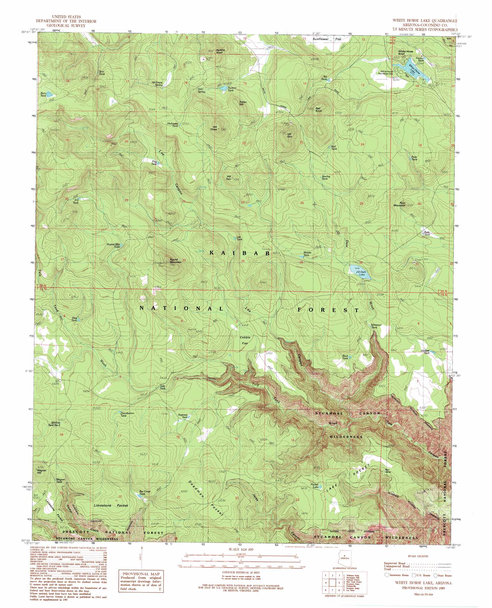
White Horse Lake Topo Map Arizona
To zoom in, hover over the map of White Horse Lake
USGS Topo Quad 35112a1 - 1:24,000 scale
| Topo Map Name: | White Horse Lake |
| USGS Topo Quad ID: | 35112a1 |
| Print Size: | ca. 21 1/4" wide x 27" high |
| Southeast Coordinates: | 35° N latitude / 112° W longitude |
| Map Center Coordinates: | 35.0625° N latitude / 112.0625° W longitude |
| U.S. State: | AZ |
| Filename: | o35112a1.jpg |
| Download Map JPG Image: | White Horse Lake topo map 1:24,000 scale |
| Map Type: | Topographic |
| Topo Series: | 7.5´ |
| Map Scale: | 1:24,000 |
| Source of Map Images: | United States Geological Survey (USGS) |
| Alternate Map Versions: |
White Horse Lake AZ 1989, updated 1990 Download PDF Buy paper map White Horse Lake AZ 1989, updated 1990 Download PDF Buy paper map White Horse Lake AZ 2012 Download PDF Buy paper map White Horse Lake AZ 2014 Download PDF Buy paper map |
| FStopo: | US Forest Service topo White Horse Lake is available: Download FStopo PDF Download FStopo TIF |
1:24,000 Topo Quads surrounding White Horse Lake
Hearst Mountain |
Williams North |
Sitgreaves Mountain |
Parks |
Wing Mountain |
Mclellan Reservoir |
Williams South |
Davenport Hill |
Garland Prairie |
Bellemont |
Matterhorn |
May Tank Pocket |
White Horse Lake |
Sycamore Point |
Dutton Hill |
Hell Point |
Perkinsville |
Sycamore Basin |
Loy Butte |
Wilson Mountain |
King Canyon |
Munds Draw |
Clarkdale |
Page Springs |
Sedona |
> Back to 35112a1 at 1:100,000 scale
> Back to 35112a1 at 1:250,000 scale
> Back to U.S. Topo Maps home
White Horse Lake topo map: Gazetteer
White Horse Lake: Flats
Cobble Flat elevation 1956m 6417′Deadman Pocket elevation 2012m 6601′
Lake Pocket elevation 1948m 6391′
Limestone Pocket elevation 1978m 6489′
Lonesome Pocket elevation 1931m 6335′
White Horse Lake: Lakes
Pocket Lake elevation 1952m 6404′White Horse Lake elevation 1998m 6555′
White Horse Lake: Parks
White Horse Recreation Site elevation 2001m 6564′White Horse Lake: Reservoirs
Bar Cross Tank elevation 1941m 6368′Boulder Tank elevation 1939m 6361′
Burn Tank elevation 2237m 7339′
Distribution Tank elevation 1967m 6453′
Elk Tank elevation 2032m 6666′
Favour Tank elevation 1987m 6519′
Flag Tank elevation 2044m 6706′
Hog Tank elevation 1982m 6502′
Holloway Tank elevation 2135m 7004′
Ike Tank elevation 2031m 6663′
JD Dam Lake elevation 1964m 6443′
Juniper Tank elevation 1940m 6364′
Lee Tank elevation 1981m 6499′
Middle Tank elevation 1989m 6525′
Perkins Tank elevation 2076m 6811′
PG Tank elevation 2093m 6866′
Pulp Tank elevation 2038m 6686′
Rain Trick Tank elevation 1934m 6345′
Red Tank elevation 2057m 6748′
Rock Tank elevation 1939m 6361′
Round Mountain Tank elevation 2052m 6732′
Ruin Tank elevation 1981m 6499′
Saginaw Tank elevation 1947m 6387′
Sawlog Tank elevation 2036m 6679′
Scar Tank elevation 2164m 7099′
Tule Tank elevation 1947m 6387′
Wagner Tank elevation 1966m 6450′
Whitetail Tank elevation 1956m 6417′
Wildlife Tank Number Two elevation 1993m 6538′
White Horse Lake: Springs
Hitt Spring elevation 2096m 6876′Holloway Spring elevation 2103m 6899′
White Horse Lake: Streams
JD Dam Wash elevation 1660m 5446′Tule Tank Wash elevation 1639m 5377′
White Horse Lake: Summits
Hill One elevation 2179m 7148′Hill Three elevation 2221m 7286′
Hill Two elevation 2105m 6906′
Indian Hill elevation 2147m 7043′
Perkins Knoll elevation 2188m 7178′
Red Knoll elevation 2173m 7129′
Round Mountain elevation 2193m 7194′
Ruin Mountain elevation 2045m 6709′
Wagner Hill elevation 2036m 6679′
White Horse Knoll elevation 2027m 6650′
White Horse Lake: Valleys
Lee Canyon elevation 1654m 5426′White Horse Lake digital topo map on disk
Buy this White Horse Lake topo map showing relief, roads, GPS coordinates and other geographical features, as a high-resolution digital map file on DVD: