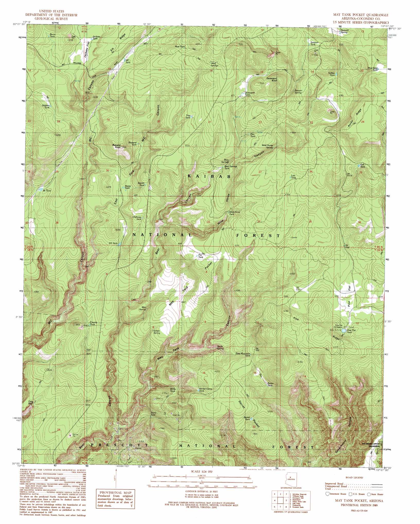
May Tank Pocket Topo Map Arizona
To zoom in, hover over the map of May Tank Pocket
USGS Topo Quad 35112a2 - 1:24,000 scale
| Topo Map Name: | May Tank Pocket |
| USGS Topo Quad ID: | 35112a2 |
| Print Size: | ca. 21 1/4" wide x 27" high |
| Southeast Coordinates: | 35° N latitude / 112.125° W longitude |
| Map Center Coordinates: | 35.0625° N latitude / 112.1875° W longitude |
| U.S. State: | AZ |
| Filename: | o35112a2.jpg |
| Download Map JPG Image: | May Tank Pocket topo map 1:24,000 scale |
| Map Type: | Topographic |
| Topo Series: | 7.5´ |
| Map Scale: | 1:24,000 |
| Source of Map Images: | United States Geological Survey (USGS) |
| Alternate Map Versions: |
May Tank Pocket AZ 1989, updated 1990 Download PDF Buy paper map May Tank Pocket AZ 2012 Download PDF Buy paper map May Tank Pocket AZ 2014 Download PDF Buy paper map |
| FStopo: | US Forest Service topo May Tank Pocket is available: Download FStopo PDF Download FStopo TIF |
1:24,000 Topo Quads surrounding May Tank Pocket
Fitzgerald Hill |
Hearst Mountain |
Williams North |
Sitgreaves Mountain |
Parks |
Ash Fork |
Mclellan Reservoir |
Williams South |
Davenport Hill |
Garland Prairie |
Meath Spring |
Matterhorn |
May Tank Pocket |
White Horse Lake |
Sycamore Point |
Paulden |
Hell Point |
Perkinsville |
Sycamore Basin |
Loy Butte |
Chino Valley North |
King Canyon |
Munds Draw |
Clarkdale |
Page Springs |
> Back to 35112a1 at 1:100,000 scale
> Back to 35112a1 at 1:250,000 scale
> Back to U.S. Topo Maps home
May Tank Pocket topo map: Gazetteer
May Tank Pocket: Basins
May Tank Pocket elevation 1845m 6053′May Tank Pocket: Cliffs
Elk Ridge elevation 1911m 6269′Rocky Ridge elevation 2168m 7112′
May Tank Pocket: Flats
Jackass Flat elevation 2003m 6571′Little Pine Flat elevation 2127m 6978′
Pine Flat elevation 1977m 6486′
Secret Pocket elevation 1862m 6108′
May Tank Pocket: Mines
Golden Bucksin Mine elevation 1582m 5190′May Tank Pocket: Reservoirs
Baldy Tank elevation 1711m 5613′Bandit Tank elevation 1948m 6391′
Bear Springs Tank elevation 2005m 6578′
Breached Tank elevation 1793m 5882′
Burro Tank elevation 2065m 6774′
Buzzard Tank elevation 1928m 6325′
County Tank elevation 1755m 5757′
Davenport Tank elevation 2065m 6774′
DT Tank elevation 1842m 6043′
Frog Pool elevation 1613m 5291′
Hat Tank elevation 2065m 6774′
Hidden Tank elevation 2000m 6561′
Highway Tank elevation 1911m 6269′
Jackass Tank elevation 2003m 6571′
Last Tank elevation 2121m 6958′
May Tank elevation 2014m 6607′
MC Tank elevation 1991m 6532′
Mud Seep Tank elevation 2221m 7286′
Mud Tank elevation 2061m 6761′
Nat Tanks elevation 1873m 6145′
Oak Tank elevation 2120m 6955′
Pine Flat Tank elevation 1994m 6541′
Pine Mountain Tank elevation 1843m 6046′
Pot Tank elevation 1975m 6479′
Rock Tank elevation 1818m 5964′
Secret Tank elevation 1813m 5948′
Sheep Tank elevation 1874m 6148′
Summit Tank elevation 2207m 7240′
Susan Tank elevation 1857m 6092′
Thirtysix Tank elevation 1850m 6069′
Trap Tank elevation 2014m 6607′
Turkey Tank elevation 2197m 7208′
Wild Horse Tank elevation 1986m 6515′
Winter Camp Tank elevation 1847m 6059′
Wyno Tank elevation 1739m 5705′
May Tank Pocket: Ridges
Pine Ridge elevation 2040m 6692′May Tank Pocket: Springs
Bear Springs elevation 2018m 6620′Ben Spring elevation 1780m 5839′
Indian Spring elevation 1820m 5971′
Mud Springs elevation 2108m 6916′
Stewart Spring elevation 2157m 7076′
Summit Spring elevation 2211m 7253′
Verde Spring elevation 1818m 5964′
Wild Horse Spring elevation 2052m 6732′
May Tank Pocket: Summits
Buzzard Knoll elevation 2028m 6653′Davenport Knoll elevation 2173m 7129′
May Tank Pocket: Trails
Overland Road Historic Trail elevation 1993m 6538′May Tank Pocket: Valleys
East Fork M C Canyon elevation 1710m 5610′May Tank Canyon elevation 1549m 5082′
Wild Horse Canyon elevation 1858m 6095′
May Tank Pocket digital topo map on disk
Buy this May Tank Pocket topo map showing relief, roads, GPS coordinates and other geographical features, as a high-resolution digital map file on DVD: