Mclellan Reservoir Topo Map Arizona
To zoom in, hover over the map of Mclellan Reservoir
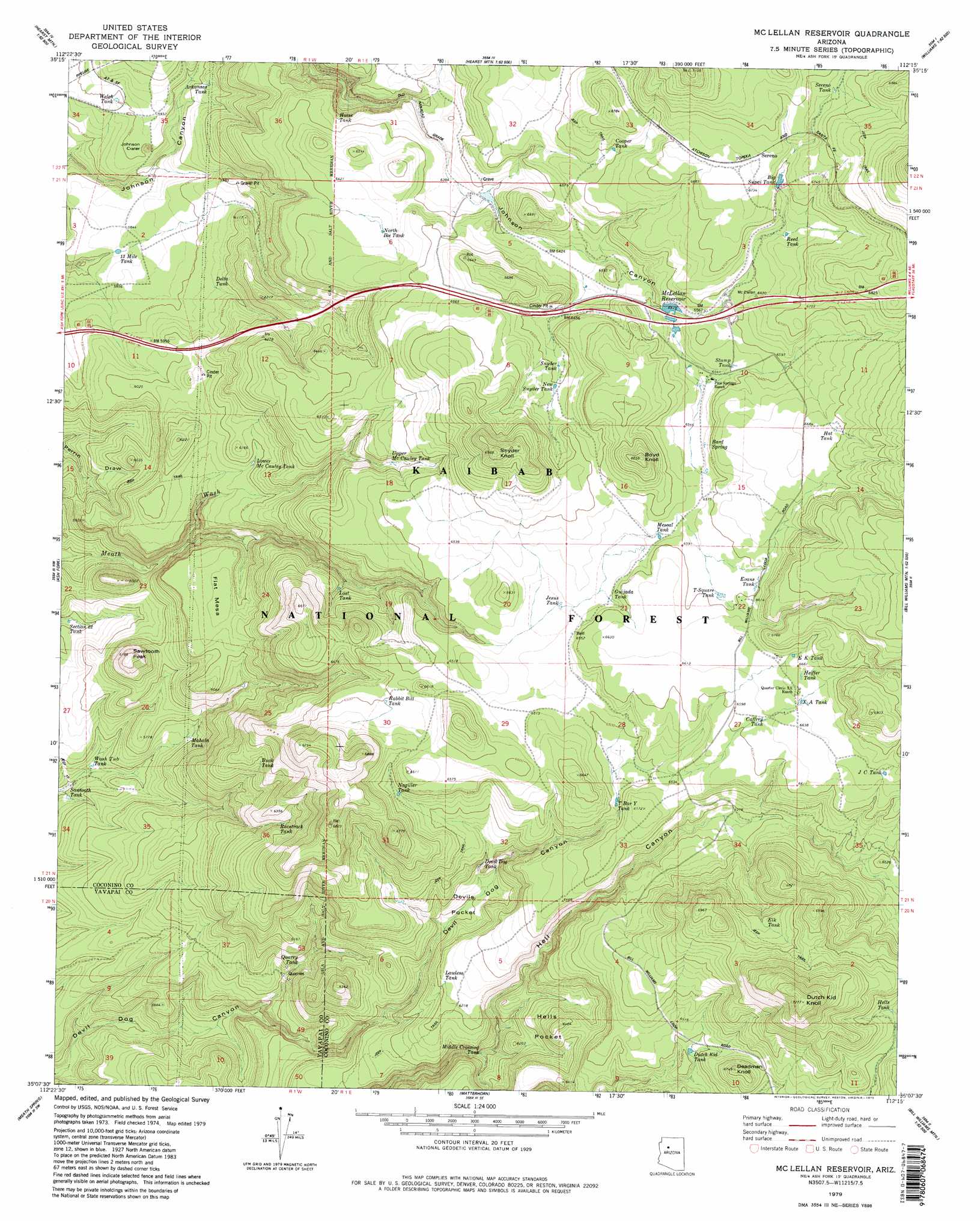
USGS Topo Quad 35112b3 - 1:24,000 scale
| Topo Map Name: | Mclellan Reservoir |
| USGS Topo Quad ID: | 35112b3 |
| Print Size: | ca. 21 1/4" wide x 27" high |
| Southeast Coordinates: | 35.125° N latitude / 112.25° W longitude |
| Map Center Coordinates: | 35.1875° N latitude / 112.3125° W longitude |
| U.S. State: | AZ |
| Filename: | o35112b3.jpg |
| Download Map JPG Image: | Mclellan Reservoir topo map 1:24,000 scale |
| Map Type: | Topographic |
| Topo Series: | 7.5´ |
| Map Scale: | 1:24,000 |
| Source of Map Images: | United States Geological Survey (USGS) |
| Alternate Map Versions: |
Mc Lellan Reservoir AZ 1979, updated 1979 Download PDF Buy paper map McLellan Reservoir AZ 1979, updated 1979 Download PDF Buy paper map McLellan Reservoir AZ 1979, updated 1979 Download PDF Buy paper map McLellan Reservoir AZ 2012 Download PDF Buy paper map McLellan Reservoir AZ 2014 Download PDF Buy paper map |
| FStopo: | US Forest Service topo McLellan Reservoir is available: Download FStopo PDF Download FStopo TIF |
1:24,000 Topo Quads surrounding Mclellan Reservoir
Eagle Nest Mountain |
Stanford Tank |
Cataract Tank |
Howard Mesa |
Squaw Mountain |
Horse Trap Mesa |
Fitzgerald Hill |
Hearst Mountain |
Williams North |
Sitgreaves Mountain |
Cathedral Caves |
Ash Fork |
Mclellan Reservoir |
Williams South |
Davenport Hill |
Picacho Butte Se |
Meath Spring |
Matterhorn |
May Tank Pocket |
White Horse Lake |
Wineglass Ranch |
Paulden |
Hell Point |
Perkinsville |
Sycamore Basin |
> Back to 35112a1 at 1:100,000 scale
> Back to 35112a1 at 1:250,000 scale
> Back to U.S. Topo Maps home
Mclellan Reservoir topo map: Gazetteer
Mclellan Reservoir: Basins
Devils Pocket elevation 1857m 6092′Hells Pocket elevation 1933m 6341′
Mclellan Reservoir: Craters
Johnson Crater elevation 1797m 5895′Mclellan Reservoir: Crossings
Devil Dog Interchange elevation 2007m 6584′Pine Springs Interchange elevation 2013m 6604′
Mclellan Reservoir: Dams
McLellan Dam elevation 1996m 6548′Mclellan Reservoir: Populated Places
Sereno elevation 2061m 6761′Sereno Spring elevation 2051m 6729′
Mclellan Reservoir: Reservoirs
Arkansas Tank elevation 1804m 5918′Big Supai Tank elevation 2041m 6696′
Bottom Tank elevation 1991m 6532′
Buck Tank elevation 1885m 6184′
Caffrey Tank elevation 2017m 6617′
Cooper Tank elevation 2011m 6597′
Delta Tank elevation 1811m 5941′
Devil Dog Tank elevation 1911m 6269′
Devil Tank elevation 1993m 6538′
Dutch Kid Tank elevation 1974m 6476′
E K Tank elevation 2030m 6660′
Elk Tank elevation 2048m 6719′
Evans Tank elevation 2012m 6601′
Guijada Tank elevation 2000m 6561′
Hat Tank elevation 2042m 6699′
Headquarters Tank elevation 1952m 6404′
Heiffer Tank elevation 2029m 6656′
Hells Tank elevation 2051m 6729′
Horse Tank elevation 1937m 6354′
J C Tank elevation 2028m 6653′
Jesus Tank elevation 1993m 6538′
Kessler Tank elevation 1910m 6266′
Lawless Tank elevation 1898m 6227′
Log Tank elevation 1877m 6158′
Lost Cow Tank elevation 1907m 6256′
Lost Tank elevation 1881m 6171′
Lower Mc Cauley Tank elevation 1852m 6076′
Mahala Tank elevation 1736m 5695′
McLellan Reservoir elevation 1987m 6519′
McLellan Siding Tank elevation 1963m 6440′
Mescal Tank elevation 2002m 6568′
Middle Crossing Tank elevation 1817m 5961′
Nagiller Tank elevation 1968m 6456′
New Synder Tank elevation 1983m 6505′
North Keesler Tank elevation 1957m 6420′
Quarry Tank elevation 1777m 5830′
Rabbit Bill Tank elevation 1983m 6505′
Racetrack Tank elevation 1889m 6197′
Reed Tank elevation 2025m 6643′
Rod Tank elevation 2045m 6709′
Sawtooth Tank elevation 1682m 5518′
Sawtooth Tank elevation 1681m 5515′
Section Twentytwo Tank elevation 1699m 5574′
Sereno Tank elevation 2064m 6771′
Snyder Tank elevation 1979m 6492′
Stevans Tank elevation 2012m 6601′
Stump Tank elevation 2002m 6568′
T Bar Y Tank elevation 1973m 6473′
Thirteen Mile Tank elevation 1774m 5820′
T-Square Tank elevation 2011m 6597′
Upper McCauley Tank elevation 1937m 6354′
Wash Tub Tank elevation 1685m 5528′
Welch Tank elevation 1796m 5892′
X A Tank elevation 2025m 6643′
Mclellan Reservoir: Springs
Andrews Spring elevation 2001m 6564′Bard Spring elevation 2017m 6617′
Mclellan Reservoir: Summits
Boyd Knoll elevation 2087m 6847′Deadman Knoll elevation 2055m 6742′
Dutch Kid Knoll elevation 2216m 7270′
Flat Mesa elevation 1849m 6066′
Sawtooth Peak elevation 1856m 6089′
Snyder Knoll elevation 2122m 6961′
Mclellan Reservoir digital topo map on disk
Buy this Mclellan Reservoir topo map showing relief, roads, GPS coordinates and other geographical features, as a high-resolution digital map file on DVD: