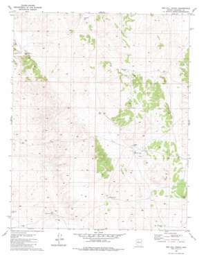
Red Hill Ranch Topo Map Arizona
To zoom in, hover over the map of Red Hill Ranch
USGS Topo Quad 35112e4 - 1:24,000 scale
| Topo Map Name: | Red Hill Ranch |
| USGS Topo Quad ID: | 35112e4 |
| Print Size: | ca. 21 1/4" wide x 27" high |
| Southeast Coordinates: | 35.5° N latitude / 112.375° W longitude |
| Map Center Coordinates: | 35.5625° N latitude / 112.4375° W longitude |
| U.S. State: | AZ |
| Filename: | o35112e4.jpg |
| Download Map JPG Image: | Red Hill Ranch topo map 1:24,000 scale |
| Map Type: | Topographic |
| Topo Series: | 7.5´ |
| Map Scale: | 1:24,000 |
| Source of Map Images: | United States Geological Survey (USGS) |
| Alternate Map Versions: |
Red Hill Ranch AZ 1981, updated 1981 Download PDF Buy paper map Red Hill Ranch AZ 2011 Download PDF Buy paper map Red Hill Ranch AZ 2014 Download PDF Buy paper map |
1:24,000 Topo Quads surrounding Red Hill Ranch
> Back to 35112e1 at 1:100,000 scale
> Back to 35112a1 at 1:250,000 scale
> Back to U.S. Topo Maps home
Red Hill Ranch topo map: Gazetteer
Red Hill Ranch: Dams
Pouquette Dam elevation 1706m 5597′Red Hill Ranch: Plains
San Francisco Plateau elevation 1808m 5931′Red Hill Ranch: Reservoirs
Big Red Hill Tank elevation 1754m 5754′Indian Tank elevation 1774m 5820′
Marshall Tank elevation 1744m 5721′
New Tank elevation 1734m 5688′
Old Freeman Tank elevation 1751m 5744′
Pouquette Tank elevation 1787m 5862′
White Tank elevation 1804m 5918′
Windy Wilson Tank elevation 1681m 5515′
Red Hill Ranch digital topo map on disk
Buy this Red Hill Ranch topo map showing relief, roads, GPS coordinates and other geographical features, as a high-resolution digital map file on DVD:


