Tusayan West Topo Map Arizona
To zoom in, hover over the map of Tusayan West
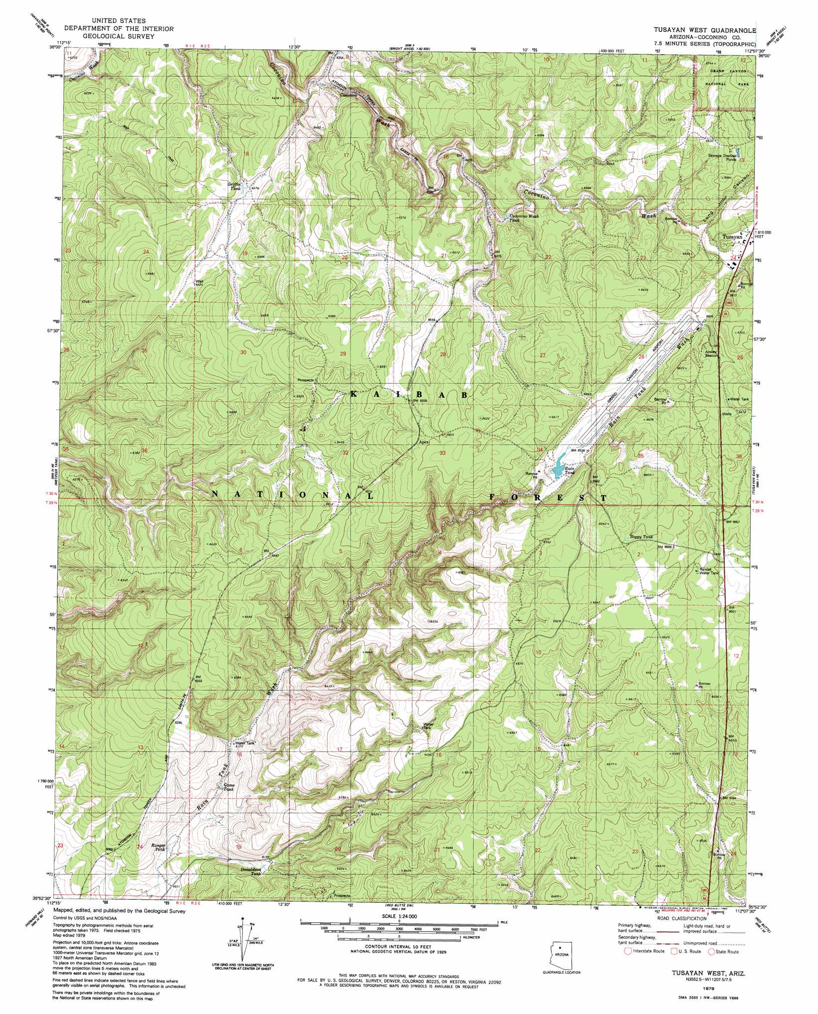
USGS Topo Quad 35112h2 - 1:24,000 scale
| Topo Map Name: | Tusayan West |
| USGS Topo Quad ID: | 35112h2 |
| Print Size: | ca. 21 1/4" wide x 27" high |
| Southeast Coordinates: | 35.875° N latitude / 112.125° W longitude |
| Map Center Coordinates: | 35.9375° N latitude / 112.1875° W longitude |
| U.S. State: | AZ |
| Filename: | o35112h2.jpg |
| Download Map JPG Image: | Tusayan West topo map 1:24,000 scale |
| Map Type: | Topographic |
| Topo Series: | 7.5´ |
| Map Scale: | 1:24,000 |
| Source of Map Images: | United States Geological Survey (USGS) |
| Alternate Map Versions: |
Tusayan West AZ 1979, updated 1980 Download PDF Buy paper map Tusayan West AZ 1979, updated 1980 Download PDF Buy paper map Tusayan West AZ 2012 Download PDF Buy paper map Tusayan West AZ 2014 Download PDF Buy paper map |
| FStopo: | US Forest Service topo Tusayan West is available: Download FStopo PDF Download FStopo TIF |
1:24,000 Topo Quads surrounding Tusayan West
Explorers Monument |
Havasupai Point |
Shiva Temple |
Bright Angel Point |
Walhalla Plateau |
Chamisa Tank |
Piute Point |
Grand Canyon |
Phantom Ranch |
Cape Royal |
Box K Ranch |
Metzger Tank |
Tusayan West |
Tusayan East |
Grandview Point |
Little Harpo Canyon |
Howard Hill |
Red Butte Sw |
Red Butte |
Harbison Tank |
Markham Dam |
Miller Tank |
Valle Tank |
Molly Ann Draw |
Dog Knobs |
> Back to 35112e1 at 1:100,000 scale
> Back to 35112a1 at 1:250,000 scale
> Back to U.S. Topo Maps home
Tusayan West topo map: Gazetteer
Tusayan West: Airports
Grand Canyon National Park Airport elevation 2002m 6568′Madison Aviation Airport elevation 2022m 6633′
Madison Aviation Heliport elevation 2020m 6627′
Tusayan Airport elevation 2012m 6601′
Tusayan Heliport elevation 2012m 6601′
Tusayan West: Populated Places
Apex elevation 2010m 6594′Coconino elevation 1941m 6368′
Tusayan elevation 2010m 6594′
Tusayan West: Reservoirs
Apex Trick Tank elevation 2003m 6571′Boggy Tank elevation 2014m 6607′
Boggy Trick Tank elevation 2022m 6633′
Coconino Wash Tank elevation 1967m 6453′
Donaldson Tank elevation 1873m 6145′
Game Tank elevation 1860m 6102′
Griffin Tank elevation 1944m 6377′
Rain Tank elevation 1989m 6525′
Randall Water Tank elevation 2013m 6604′
Ranger Tank elevation 1842m 6043′
Tusayan West: Valleys
Long Jim Canyon elevation 2005m 6578′Tusayan West digital topo map on disk
Buy this Tusayan West topo map showing relief, roads, GPS coordinates and other geographical features, as a high-resolution digital map file on DVD: