White Hills West Topo Map Arizona
To zoom in, hover over the map of White Hills West
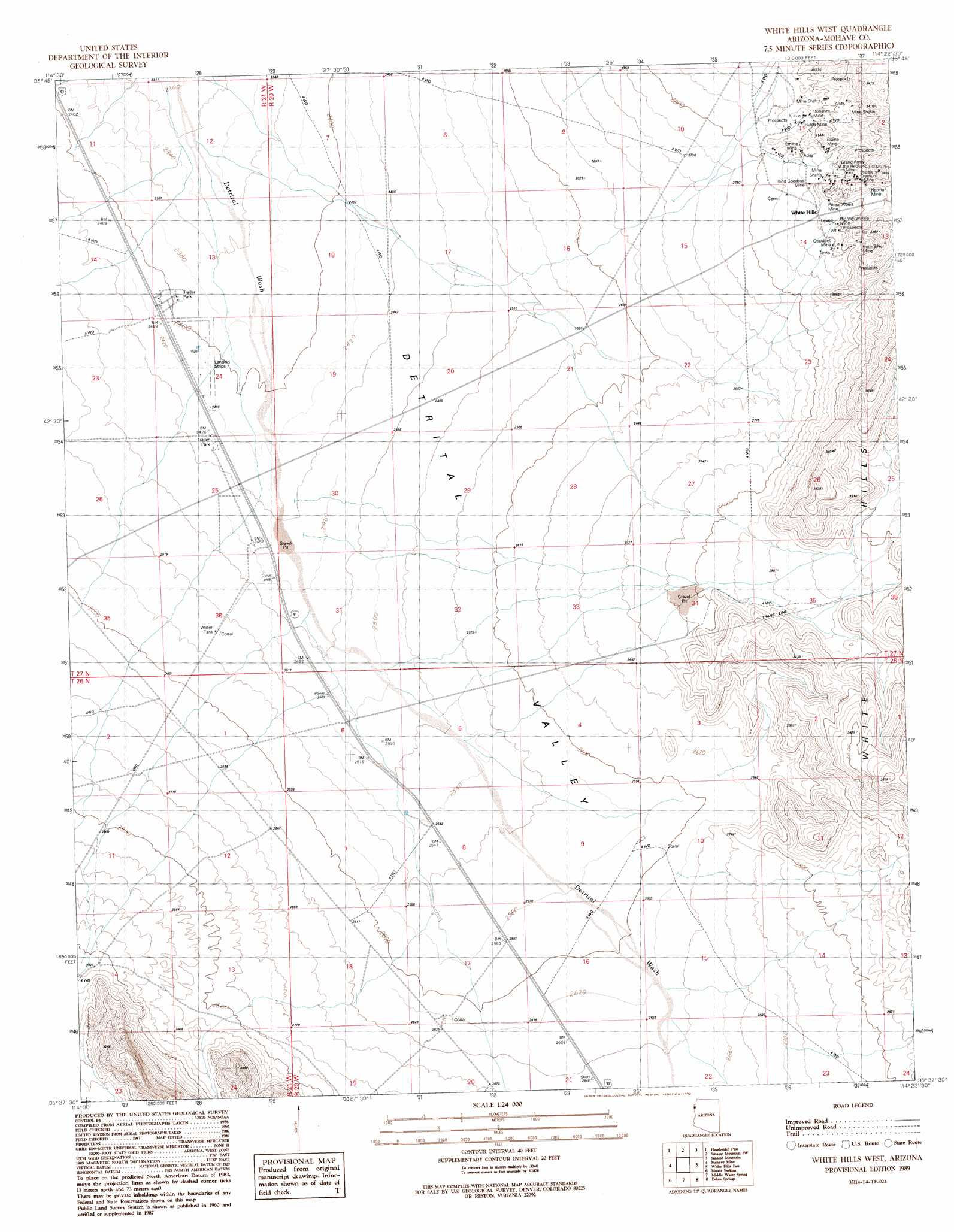
USGS Topo Quad 35114f4 - 1:24,000 scale
| Topo Map Name: | White Hills West |
| USGS Topo Quad ID: | 35114f4 |
| Print Size: | ca. 21 1/4" wide x 27" high |
| Southeast Coordinates: | 35.625° N latitude / 114.375° W longitude |
| Map Center Coordinates: | 35.6875° N latitude / 114.4375° W longitude |
| U.S. State: | AZ |
| Filename: | o35114f4.jpg |
| Download Map JPG Image: | White Hills West topo map 1:24,000 scale |
| Map Type: | Topographic |
| Topo Series: | 7.5´ |
| Map Scale: | 1:24,000 |
| Source of Map Images: | United States Geological Survey (USGS) |
| Alternate Map Versions: |
White Hills West AZ 1989, updated 1990 Download PDF Buy paper map White Hills West AZ 2011 Download PDF Buy paper map White Hills West AZ 2014 Download PDF Buy paper map |
1:24,000 Topo Quads surrounding White Hills West
Ringbolt Rapids |
Mount Wilson |
Senator Mountain Nw |
Senator Mountain Ne |
Garnet Mountain Nw |
Willow Beach |
Housholder Pass |
Senator Mountain Sw |
Senator Mountain |
Gold Basin |
Fire Mountain |
Mohave Mine |
White Hills West |
White Hills East |
Mount Tipton Nw |
Mount Davis |
Mount Perkins |
Middle Water Spring |
Dolan Springs |
Mount Tipton |
Spirit Mountain Nw |
Spirit Mountain Ne |
Grasshopper Junction Nw |
Grasshopper Junction |
Chloride |
> Back to 35114e1 at 1:100,000 scale
> Back to 35114a1 at 1:250,000 scale
> Back to U.S. Topo Maps home
White Hills West topo map: Gazetteer
White Hills West: Airports
Triangle Airpark elevation 737m 2417′White Hills West: Mines
Blind Goddess Mine elevation 879m 2883′Bonanza Mine elevation 901m 2956′
Grand Army of Republic Mine elevation 909m 2982′
Horn Silver Mine elevation 923m 3028′
Hulda Mine elevation 890m 2919′
Norma Mines elevation 926m 3038′
Occident Mine elevation 908m 2979′
Prince Albert Mine elevation 906m 2972′
Rip Van Winkle Mine elevation 926m 3038′
Shaefers Treasure Mine elevation 0m 0′
White Hills West: Populated Places
White Hills elevation 851m 2791′White Hills West digital topo map on disk
Buy this White Hills West topo map showing relief, roads, GPS coordinates and other geographical features, as a high-resolution digital map file on DVD:
Southern Sierra Nevada, California & Southern Nevada
Buy digital topo maps: Southern Sierra Nevada, California & Southern Nevada