Fire Mountain Topo Map Arizona
To zoom in, hover over the map of Fire Mountain
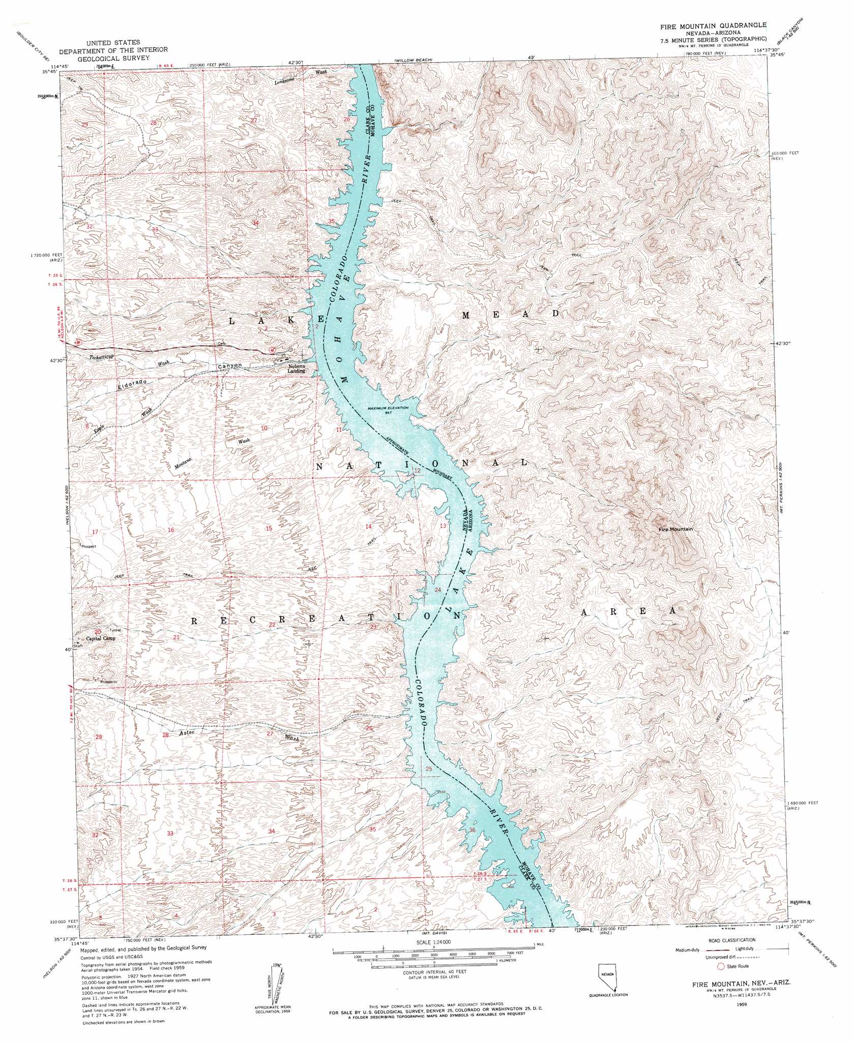
USGS Topo Quad 35114f6 - 1:24,000 scale
| Topo Map Name: | Fire Mountain |
| USGS Topo Quad ID: | 35114f6 |
| Print Size: | ca. 21 1/4" wide x 27" high |
| Southeast Coordinates: | 35.625° N latitude / 114.625° W longitude |
| Map Center Coordinates: | 35.6875° N latitude / 114.6875° W longitude |
| U.S. States: | AZ, NV |
| Filename: | o35114f6.jpg |
| Download Map JPG Image: | Fire Mountain topo map 1:24,000 scale |
| Map Type: | Topographic |
| Topo Series: | 7.5´ |
| Map Scale: | 1:24,000 |
| Source of Map Images: | United States Geological Survey (USGS) |
| Alternate Map Versions: |
Fire Mountain AZ 1959, updated 1960 Download PDF Buy paper map Fire Mountain AZ 1959, updated 1978 Download PDF Buy paper map Fire Mountain AZ 2011 Download PDF Buy paper map Fire Mountain AZ 2014 Download PDF Buy paper map |
1:24,000 Topo Quads surrounding Fire Mountain
Boulder City Nw |
Boulder City |
Ringbolt Rapids |
Mount Wilson |
Senator Mountain Nw |
Boulder City Sw |
Boulder City Se |
Willow Beach |
Housholder Pass |
Senator Mountain Sw |
Keyhole Canyon |
Nelson |
Fire Mountain |
Mohave Mine |
White Hills West |
Nelson Sw |
Ireteba Peaks |
Mount Davis |
Mount Perkins |
Middle Water Spring |
Searchlight |
Fourth Of July Mountain |
Spirit Mountain Nw |
Spirit Mountain Ne |
Grasshopper Junction Nw |
> Back to 35114e1 at 1:100,000 scale
> Back to 35114a1 at 1:250,000 scale
> Back to U.S. Topo Maps home
Fire Mountain topo map: Gazetteer
Fire Mountain: Arroyos
Aurora Wash elevation 479m 1571′Capitol Wash elevation 202m 662′
Fire Mountain: Bays
Burny Cove elevation 197m 646′Capital Camp Cove elevation 197m 646′
Dixie Cove elevation 197m 646′
Dolly Hill Cove elevation 197m 646′
Eagle Cove elevation 197m 646′
Elizabeth J Cove elevation 197m 646′
Fire Mountain Cove elevation 197m 646′
Fortune Cove elevation 197m 646′
Fox Cove elevation 197m 646′
Gold Bug Cove elevation 197m 646′
Liberty Cove elevation 197m 646′
Lonesome Wash Cove elevation 200m 656′
Lookout Cove elevation 197m 646′
Millsite Cove elevation 197m 646′
Morning Star Cove elevation 197m 646′
Oil Pan Cove elevation 197m 646′
Orion Cove elevation 197m 646′
Oro Cove elevation 197m 646′
Placer Cove elevation 197m 646′
Plateau Cove elevation 197m 646′
Pope Mine Cove elevation 197m 646′
Porter Mine Cove elevation 197m 646′
Red Cap Cove elevation 197m 646′
Red Cloud Cove elevation 197m 646′
Red Tail Cove elevation 197m 646′
Roadrunner Cove elevation 197m 646′
Russian Cove elevation 197m 646′
Techatticup Cove elevation 197m 646′
Tornado Cove elevation 197m 646′
Tule Wash Cove elevation 197m 646′
Waterspout Cove elevation 197m 646′
Fire Mountain: Islands
Two Rocks elevation 197m 646′Fire Mountain: Populated Places
Eldorado Canyon (historical) elevation 218m 715′Fire Mountain: Post Offices
Eldorado Canyon Post Office (historical) elevation 217m 711′Fire Mountain: Streams
Aztec Wash elevation 203m 666′Eagle Wash elevation 199m 652′
Lonesome Wash elevation 203m 666′
Montana Wash elevation 212m 695′
Power Line Wash elevation 197m 646′
Techatticup Wash elevation 248m 813′
Fire Mountain: Summits
Fire Mountain elevation 750m 2460′Fire Mountain: Valleys
Eldorado Canyon elevation 199m 652′Lower Black Canyon elevation 197m 646′
Fire Mountain digital topo map on disk
Buy this Fire Mountain topo map showing relief, roads, GPS coordinates and other geographical features, as a high-resolution digital map file on DVD:
Southern Sierra Nevada, California & Southern Nevada
Buy digital topo maps: Southern Sierra Nevada, California & Southern Nevada