Boulder City Sw Topo Map Nevada
To zoom in, hover over the map of Boulder City Sw
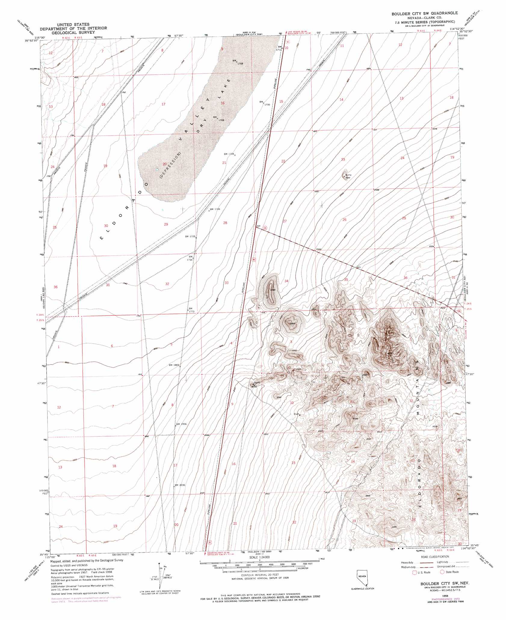
USGS Topo Quad 35114g8 - 1:24,000 scale
| Topo Map Name: | Boulder City Sw |
| USGS Topo Quad ID: | 35114g8 |
| Print Size: | ca. 21 1/4" wide x 27" high |
| Southeast Coordinates: | 35.75° N latitude / 114.875° W longitude |
| Map Center Coordinates: | 35.8125° N latitude / 114.9375° W longitude |
| U.S. State: | NV |
| Filename: | o35114g8.jpg |
| Download Map JPG Image: | Boulder City Sw topo map 1:24,000 scale |
| Map Type: | Topographic |
| Topo Series: | 7.5´ |
| Map Scale: | 1:24,000 |
| Source of Map Images: | United States Geological Survey (USGS) |
| Alternate Map Versions: |
Boulder City SW NV 1958, updated 1959 Download PDF Buy paper map Boulder City SW NV 1958, updated 1976 Download PDF Buy paper map Boulder City SW NV 2012 Download PDF Buy paper map Boulder City SW NV 2014 Download PDF Buy paper map |
1:24,000 Topo Quads surrounding Boulder City Sw
Las Vegas Sw |
Las Vegas Se |
Henderson |
Boulder Beach |
Hoover Dam |
Sloan |
Sloan Ne |
Boulder City Nw |
Boulder City |
Ringbolt Rapids |
Hidden Valley |
Sloan Se |
Boulder City Sw |
Boulder City Se |
Willow Beach |
Mccullough Pass |
Mccullough Mountain Ne |
Keyhole Canyon |
Nelson |
Fire Mountain |
Mccullough Mountain |
Highland Spring |
Nelson Sw |
Ireteba Peaks |
Mount Davis |
> Back to 35114e1 at 1:100,000 scale
> Back to 35114a1 at 1:250,000 scale
> Back to U.S. Topo Maps home
Boulder City Sw topo map: Gazetteer
Boulder City Sw: Basins
Eldorado Valley elevation 554m 1817′Boulder City Sw: Flats
Dry Lake elevation 522m 1712′Boulder City Sw: Reservoirs
C C C Reservoir elevation 521m 1709′Dry Lake Reservoir elevation 525m 1722′
Mursha Reservoir elevation 520m 1706′
Boulder City Sw digital topo map on disk
Buy this Boulder City Sw topo map showing relief, roads, GPS coordinates and other geographical features, as a high-resolution digital map file on DVD:
Southern Sierra Nevada, California & Southern Nevada
Buy digital topo maps: Southern Sierra Nevada, California & Southern Nevada