Ringbolt Rapids Topo Map Arizona
To zoom in, hover over the map of Ringbolt Rapids
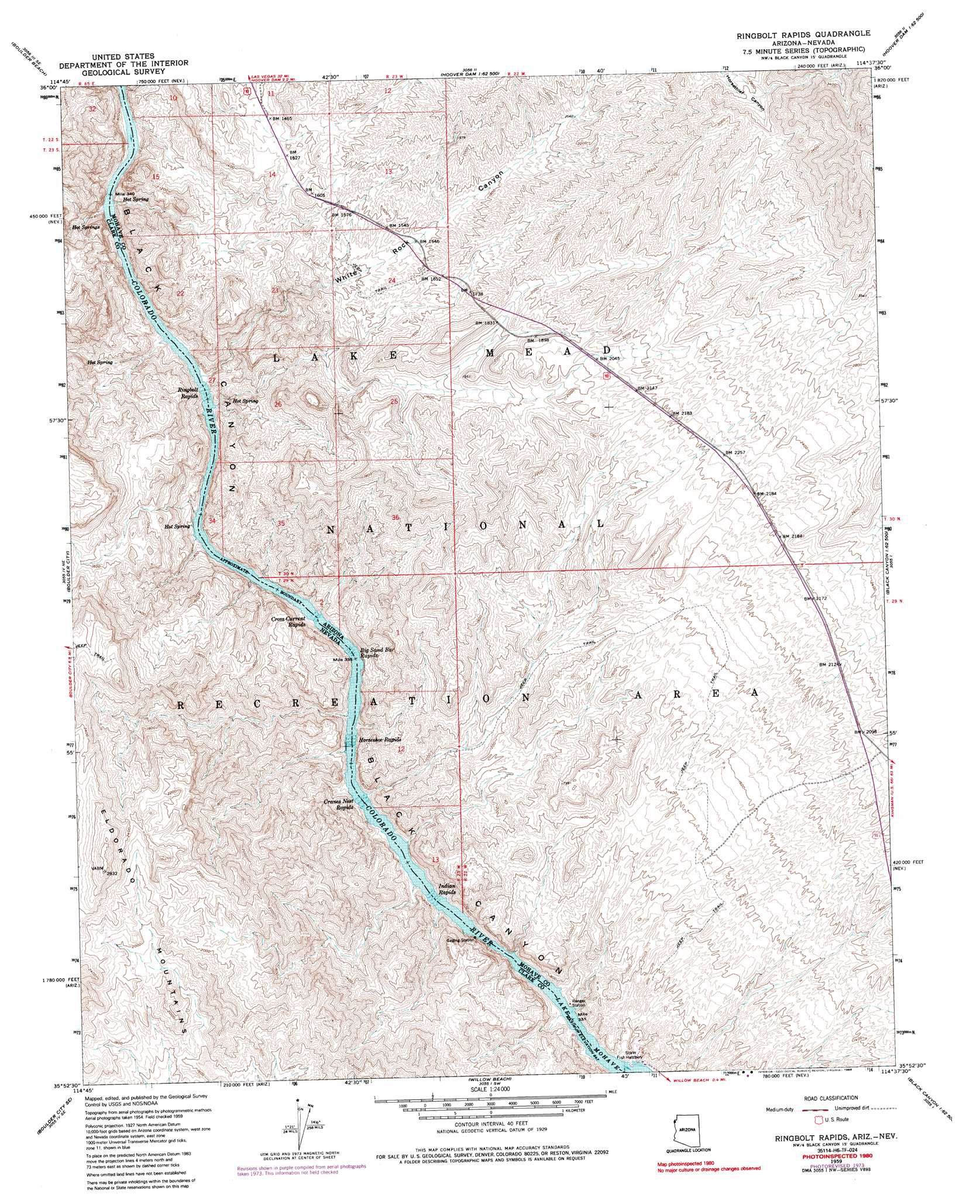
USGS Topo Quad 35114h6 - 1:24,000 scale
| Topo Map Name: | Ringbolt Rapids |
| USGS Topo Quad ID: | 35114h6 |
| Print Size: | ca. 21 1/4" wide x 27" high |
| Southeast Coordinates: | 35.875° N latitude / 114.625° W longitude |
| Map Center Coordinates: | 35.9375° N latitude / 114.6875° W longitude |
| U.S. States: | AZ, NV |
| Filename: | o35114h6.jpg |
| Download Map JPG Image: | Ringbolt Rapids topo map 1:24,000 scale |
| Map Type: | Topographic |
| Topo Series: | 7.5´ |
| Map Scale: | 1:24,000 |
| Source of Map Images: | United States Geological Survey (USGS) |
| Alternate Map Versions: |
Ringbolt Rapids AZ 1959, updated 1960 Download PDF Buy paper map Ringbolt Rapids AZ 1959, updated 1973 Download PDF Buy paper map Ringbolt Rapids AZ 1959, updated 1976 Download PDF Buy paper map Ringbolt Rapids AZ 1959, updated 1985 Download PDF Buy paper map Ringbolt Rapids AZ 2011 Download PDF Buy paper map Ringbolt Rapids AZ 2014 Download PDF Buy paper map |
1:24,000 Topo Quads surrounding Ringbolt Rapids
Frenchman Mountain |
Government Wash |
Callville Bay |
Boulder Canyon |
Middle Point |
Henderson |
Boulder Beach |
Hoover Dam |
Petroglyph Wash |
Bonelli Bay |
Boulder City Nw |
Boulder City |
Ringbolt Rapids |
Mount Wilson |
Senator Mountain Nw |
Boulder City Sw |
Boulder City Se |
Willow Beach |
Housholder Pass |
Senator Mountain Sw |
Keyhole Canyon |
Nelson |
Fire Mountain |
Mohave Mine |
White Hills West |
> Back to 35114e1 at 1:100,000 scale
> Back to 35114a1 at 1:250,000 scale
> Back to U.S. Topo Maps home
Ringbolt Rapids topo map: Gazetteer
Ringbolt Rapids: Arches
Liberty Bell Arch elevation 473m 1551′Ringbolt Rapids: Bars
Big Sand Bar elevation 231m 757′Ringbolt Rapids: Rapids
Big Sand Bar elevation 197m 646′Big Sand Bar Rapids elevation 197m 646′
Cranes Nest Rapids elevation 197m 646′
Cranes Nest Rapids elevation 197m 646′
Cross Current Rapids elevation 197m 646′
Cross Current Rapids elevation 208m 682′
Horseshoe Rapids elevation 209m 685′
Horseshoe Rapids elevation 197m 646′
Indian Rapids elevation 197m 646′
Indian Rapids elevation 197m 646′
Ringbolt Rapids elevation 231m 757′
Ringbolt Rapids elevation 197m 646′
Rocky Rapids elevation 223m 731′
Ringbolt Rapids: Springs
Hot Spring elevation 257m 843′Hot Spring elevation 229m 751′
Hot Spring elevation 239m 784′
Hot Springs elevation 269m 882′
Lost Man Hot Spring elevation 244m 800′
Ringbolt Hot Spring elevation 231m 757′
Two Mile Hot Spring elevation 269m 882′
Ringbolt Rapids: Streams
Cranes Nest Wash elevation 200m 656′Ringbolt Rapids: Valleys
Boy Scout Canyon elevation 197m 646′The Chute elevation 197m 646′
The Chute elevation 197m 646′
White Rock Canyon elevation 200m 656′
Ringbolt Rapids digital topo map on disk
Buy this Ringbolt Rapids topo map showing relief, roads, GPS coordinates and other geographical features, as a high-resolution digital map file on DVD:
Southern Sierra Nevada, California & Southern Nevada
Buy digital topo maps: Southern Sierra Nevada, California & Southern Nevada