Cima Dome Topo Map California
To zoom in, hover over the map of Cima Dome
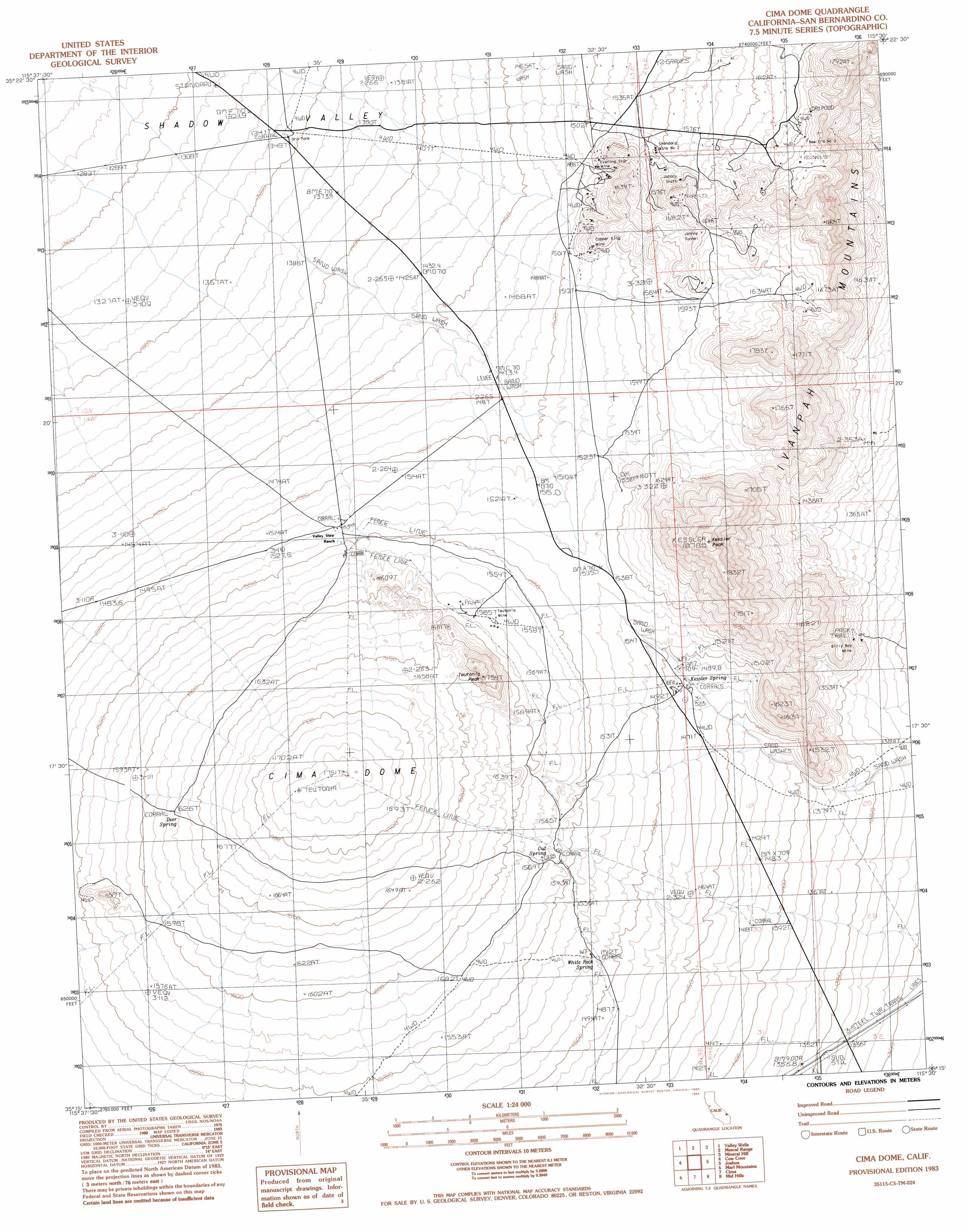
USGS Topo Quad 35115c5 - 1:24,000 scale
| Topo Map Name: | Cima Dome |
| USGS Topo Quad ID: | 35115c5 |
| Print Size: | ca. 21 1/4" wide x 27" high |
| Southeast Coordinates: | 35.25° N latitude / 115.5° W longitude |
| Map Center Coordinates: | 35.3125° N latitude / 115.5625° W longitude |
| U.S. State: | CA |
| Filename: | o35115c5.jpg |
| Download Map JPG Image: | Cima Dome topo map 1:24,000 scale |
| Map Type: | Topographic |
| Topo Series: | 7.5´ |
| Map Scale: | 1:24,000 |
| Source of Map Images: | United States Geological Survey (USGS) |
| Alternate Map Versions: |
Cima Dome CA 1983, updated 1983 Download PDF Buy paper map Cima Dome CA 2012 Download PDF Buy paper map Cima Dome CA 2015 Download PDF Buy paper map |
1:24,000 Topo Quads surrounding Cima Dome
East Of Kingston Spring |
Pachalka Spring |
Clark Mountain |
Ivanpah Lake |
Desert |
Solomons Knob |
Valley Wells |
Mescal Range |
Mineral Hill |
Nipton |
Granite Spring |
Cow Cove |
Cima Dome |
Joshua |
Ivanpah |
Indian Spring |
Marl Mountains |
Cima |
Mid Hills |
Pinto Valley |
Old Dad Mountain |
Kelso |
Hayden |
Columbia Mountain |
Woods Mountains |
> Back to 35115a1 at 1:100,000 scale
> Back to 35114a1 at 1:250,000 scale
> Back to U.S. Topo Maps home
Cima Dome topo map: Gazetteer
Cima Dome: Mines
Billy Boy Mine elevation 1382m 4534′Copper King Mine elevation 1544m 5065′
Evening Star Mine elevation 1512m 4960′
Geer Dolomite Quarry elevation 1669m 5475′
Geer Prospect elevation 1557m 5108′
Ginn Prospect elevation 1750m 5741′
Hartman Mine elevation 1542m 5059′
Johnny Prospects elevation 1640m 5380′
Johnny Shaft elevation 1608m 5275′
Johnny Tunnel elevation 1663m 5456′
New Era Mine elevation 1667m 5469′
New Era Number Three Mine elevation 1664m 5459′
Rex Prospect elevation 1535m 5036′
Ross Prospect elevation 1700m 5577′
Standard Mine Number Two elevation 1552m 5091′
Teutonia Mine elevation 1585m 5200′
Cima Dome: Ranges
Ivanpah Mountains elevation 1688m 5538′Cima Dome: Reservoirs
Ord Tank elevation 1347m 4419′Cima Dome: Springs
Cut Spring elevation 1569m 5147′Deer Spring elevation 1621m 5318′
Kessler Spring elevation 1487m 4878′
White Rock Spring elevation 1519m 4983′
Cima Dome: Summits
Cima Dome elevation 1751m 5744′Kessler Peak elevation 1876m 6154′
Teutonia Peak elevation 1715m 5626′
Cima Dome digital topo map on disk
Buy this Cima Dome topo map showing relief, roads, GPS coordinates and other geographical features, as a high-resolution digital map file on DVD:
Southern Sierra Nevada, California & Southern Nevada
Buy digital topo maps: Southern Sierra Nevada, California & Southern Nevada