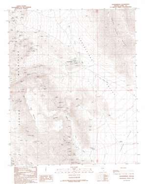
Goodsprings Topo Map Nevada
To zoom in, hover over the map of Goodsprings
USGS Topo Quad 35115g4 - 1:24,000 scale
| Topo Map Name: | Goodsprings |
| USGS Topo Quad ID: | 35115g4 |
| Print Size: | ca. 21 1/4" wide x 27" high |
| Southeast Coordinates: | 35.75° N latitude / 115.375° W longitude |
| Map Center Coordinates: | 35.8125° N latitude / 115.4375° W longitude |
| U.S. State: | NV |
| Filename: | o35115g4.jpg |
| Download Map JPG Image: | Goodsprings topo map 1:24,000 scale |
| Map Type: | Topographic |
| Topo Series: | 7.5´ |
| Map Scale: | 1:24,000 |
| Source of Map Images: | United States Geological Survey (USGS) |
| Alternate Map Versions: |
Goodsprings NV 1989, updated 1990 Download PDF Buy paper map Goodsprings NV 1989, updated 1990 Download PDF Buy paper map Goodsprings NV 2012 Download PDF Buy paper map Goodsprings NV 2014 Download PDF Buy paper map |
1:24,000 Topo Quads surrounding Goodsprings
> Back to 35115e1 at 1:100,000 scale
> Back to 35114a1 at 1:250,000 scale
> Back to U.S. Topo Maps home
Goodsprings topo map: Gazetteer
Goodsprings: Basins
Goodsprings Valley elevation 1087m 3566′Goodsprings: Gaps
Columbia Pass elevation 1369m 4491′Crystal Pass elevation 1156m 3792′
Goodsprings: Mines
Accident Mine elevation 1273m 4176′Alice Mine elevation 1545m 5068′
Anchor Mine elevation 1327m 4353′
Argentena Mine elevation 1488m 4881′
Belle Mine elevation 1367m 4484′
Bullion Mine elevation 1193m 3914′
Columbia Mine elevation 1375m 4511′
Cosmopolitan Mine elevation 1380m 4527′
Frederickson Mine elevation 1341m 4399′
Green Copper Mine elevation 1423m 4668′
Hermosa Mine elevation 1365m 4478′
Hoosier Mine elevation 1277m 4189′
Houghton Mine elevation 1209m 3966′
Ireland Mine elevation 1023m 3356′
Iron Gold Mine elevation 1281m 4202′
Lavina Mine elevation 1292m 4238′
Lincoln Mine elevation 1005m 3297′
Lookout Mine elevation 1433m 4701′
Middlesex Mine elevation 1449m 4753′
Monte Cristo Mine elevation 1168m 3832′
Mountain Top Mine elevation 1394m 4573′
Pilgrim Mine elevation 1388m 4553′
Porter Mine elevation 1255m 4117′
Prairie Flower Mine elevation 1395m 4576′
Puelz Mine elevation 1300m 4265′
Red Cloud Mine elevation 1392m 4566′
Ruth Mine elevation 1354m 4442′
Star Mine elevation 1255m 4117′
Surprise Mine elevation 1473m 4832′
Valentine Mine elevation 1293m 4242′
Volcano Mine elevation 1499m 4917′
Yellow Pine Mine elevation 1428m 4685′
Goodsprings: Parks
Goodsprings Park elevation 1138m 3733′Goodsprings: Populated Places
Goodsprings elevation 1130m 3707′Goodsprings: Post Offices
Goodsprings Rural Station Post Office elevation 1130m 3707′Goodsprings: Springs
Good Spring elevation 1136m 3727′New England Mining Companys Spring elevation 1151m 3776′
New England Springs elevation 1192m 3910′
Goodsprings: Streams
Porter Wash elevation 1006m 3300′Goodsprings: Summits
Lookout Peak elevation 1217m 3992′Table Mountain elevation 1565m 5134′
Goodsprings: Valleys
Deadmans Canyon elevation 1124m 3687′Horseshoe Gulch elevation 1339m 4393′
Porphyry Gulch elevation 1408m 4619′
Goodsprings digital topo map on disk
Buy this Goodsprings topo map showing relief, roads, GPS coordinates and other geographical features, as a high-resolution digital map file on DVD:
Southern Sierra Nevada, California & Southern Nevada
Buy digital topo maps: Southern Sierra Nevada, California & Southern Nevada


