Shenandoah Peak Topo Map Nevada
To zoom in, hover over the map of Shenandoah Peak
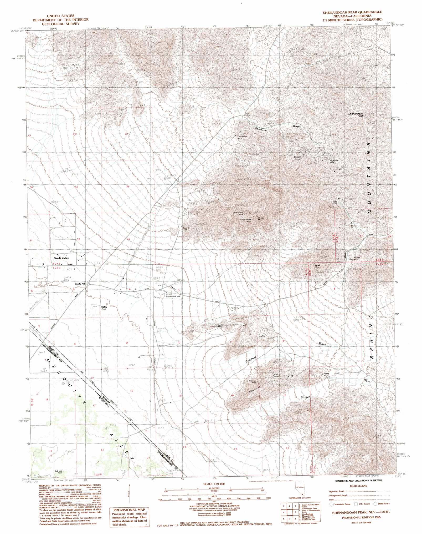
USGS Topo Quad 35115g5 - 1:24,000 scale
| Topo Map Name: | Shenandoah Peak |
| USGS Topo Quad ID: | 35115g5 |
| Print Size: | ca. 21 1/4" wide x 27" high |
| Southeast Coordinates: | 35.75° N latitude / 115.5° W longitude |
| Map Center Coordinates: | 35.8125° N latitude / 115.5625° W longitude |
| U.S. States: | NV, CA |
| Filename: | o35115g5.jpg |
| Download Map JPG Image: | Shenandoah Peak topo map 1:24,000 scale |
| Map Type: | Topographic |
| Topo Series: | 7.5´ |
| Map Scale: | 1:24,000 |
| Source of Map Images: | United States Geological Survey (USGS) |
| Alternate Map Versions: |
Shenandoah Peak NV 1985, updated 1985 Download PDF Buy paper map Shenandoah Peak NV 1985, updated 1985 Download PDF Buy paper map Shenandoah Peak NV 2012 Download PDF Buy paper map Shenandoah Peak NV 2014 Download PDF Buy paper map |
1:24,000 Topo Quads surrounding Shenandoah Peak
Hidden Hills Ranch |
Lost Cabin Spring |
Mountain Springs |
Blue Diamond |
Blue Diamond Se |
Stump Spring |
Green Monster Mine |
Potosi |
Cottonwood Pass |
Bird Spring |
Blackwater Mine |
West Of Shenandoah Peak |
Shenandoah Peak |
Goodsprings |
Jean |
East Of Kingston Peak |
Mesquite Mountain |
Mesquite Lake |
State Line Pass |
Roach |
East Of Kingston Spring |
Pachalka Spring |
Clark Mountain |
Ivanpah Lake |
Desert |
> Back to 35115e1 at 1:100,000 scale
> Back to 35114a1 at 1:250,000 scale
> Back to U.S. Topo Maps home
Shenandoah Peak topo map: Gazetteer
Shenandoah Peak: Mines
Akron Mine elevation 1261m 4137′Azurite Mine elevation 1063m 3487′
Bill Nye Mine elevation 1221m 4005′
Boss Mine elevation 978m 3208′
Chiquita Mine elevation 1411m 4629′
Clementina Mine elevation 1512m 4960′
Copper Chief Mine elevation 1426m 4678′
Copper Flower Mine elevation 955m 3133′
Copperside Mine elevation 1146m 3759′
Golden Chariot Mine elevation 1570m 5150′
Highline Mine elevation 1234m 4048′
Hoodoo Mine elevation 895m 2936′
Ironside Mine elevation 1166m 3825′
Keystone Mine elevation 1540m 5052′
Kirby Mine elevation 1437m 4714′
McVicar Mine elevation 939m 3080′
Mobile Mine elevation 1365m 4478′
Oro Amigo Mine elevation 1221m 4005′
Platina Mine elevation 1063m 3487′
Root Mine elevation 1074m 3523′
Shenandoah Mine elevation 1345m 4412′
Singer Mine elevation 1044m 3425′
Smithsonite Mine elevation 1201m 3940′
Spelter Mine elevation 890m 2919′
Sultan Mine elevation 1268m 4160′
Tiffin Mine elevation 998m 3274′
Whale Mine elevation 1156m 3792′
Shenandoah Peak: Populated Places
Lincoln City elevation 792m 2598′Platina (historical) elevation 826m 2709′
Ripley elevation 799m 2621′
Root Camp (historical) elevation 937m 3074′
Sandy Mill elevation 805m 2641′
Shenandoah Peak: Post Offices
Keystone Post Office elevation 800m 2624′Platina Post Office elevation 826m 2709′
Ripley Post Office elevation 799m 2621′
Sandy Post Office elevation 805m 2641′
Shenandoah Peak: Streams
Bonanza Wash elevation 819m 2687′Galena Wash elevation 1204m 3950′
Keystone Wash elevation 810m 2657′
Kirby Wash elevation 956m 3136′
Singer Wash elevation 869m 2851′
Shenandoah Peak: Summits
Bonanza Hill elevation 1140m 3740′Cairn East of Shenandoah Mine elevation 1200m 3937′
Ragged Peak elevation 1533m 5029′
Rattler Hill elevation 1583m 5193′
Shenandoah Peak elevation 1782m 5846′
Shenandoah Peak: Wells
Cub Lee Well elevation 779m 2555′Shenandoah Peak digital topo map on disk
Buy this Shenandoah Peak topo map showing relief, roads, GPS coordinates and other geographical features, as a high-resolution digital map file on DVD:
Southern Sierra Nevada, California & Southern Nevada
Buy digital topo maps: Southern Sierra Nevada, California & Southern Nevada