Horse Thief Springs Topo Map California
To zoom in, hover over the map of Horse Thief Springs
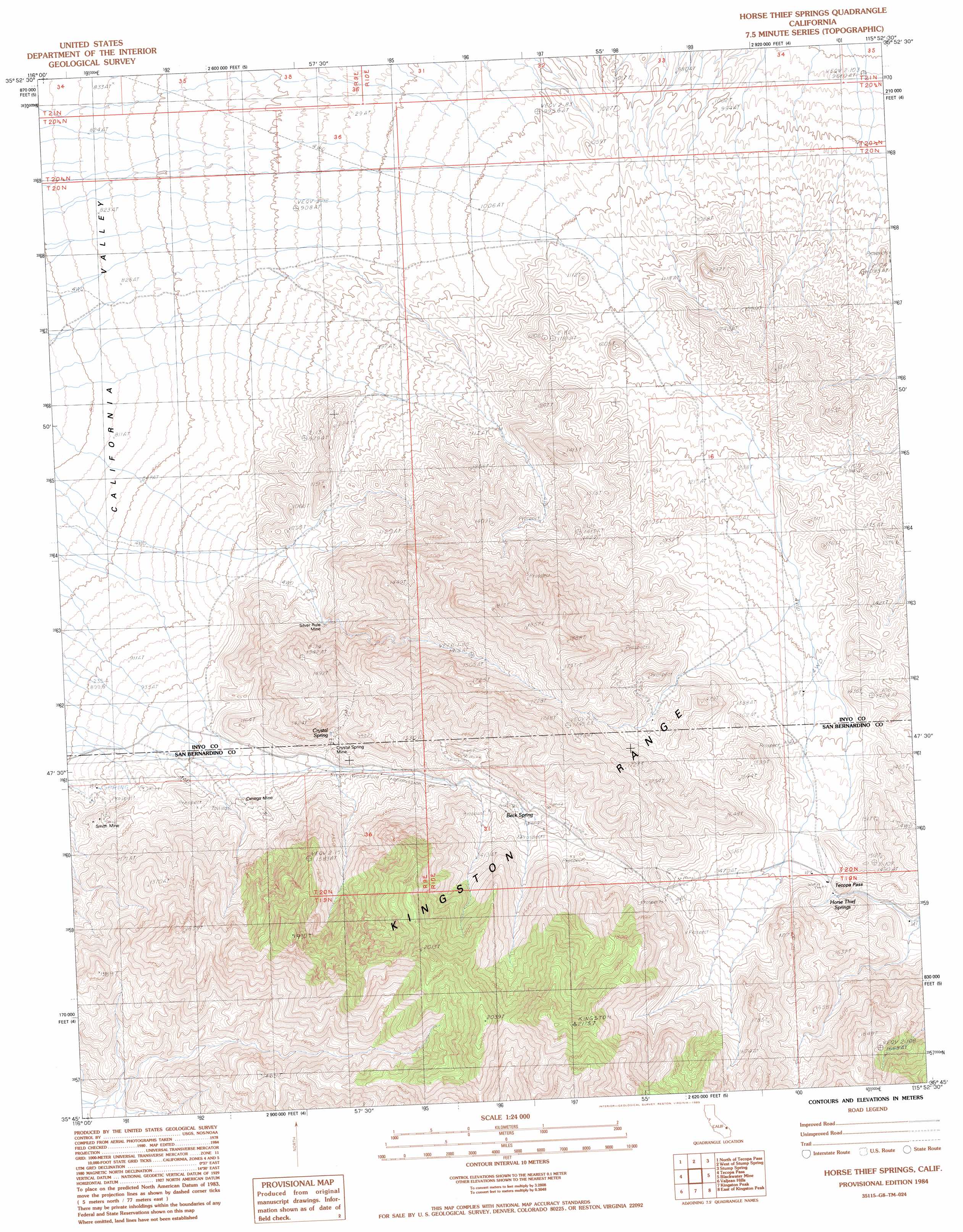
USGS Topo Quad 35115g8 - 1:24,000 scale
| Topo Map Name: | Horse Thief Springs |
| USGS Topo Quad ID: | 35115g8 |
| Print Size: | ca. 21 1/4" wide x 27" high |
| Southeast Coordinates: | 35.75° N latitude / 115.875° W longitude |
| Map Center Coordinates: | 35.8125° N latitude / 115.9375° W longitude |
| U.S. State: | CA |
| Filename: | o35115g8.jpg |
| Download Map JPG Image: | Horse Thief Springs topo map 1:24,000 scale |
| Map Type: | Topographic |
| Topo Series: | 7.5´ |
| Map Scale: | 1:24,000 |
| Source of Map Images: | United States Geological Survey (USGS) |
| Alternate Map Versions: |
Horse Thief Springs CA 1984, updated 1985 Download PDF Buy paper map Horse Thief Springs CA 2012 Download PDF Buy paper map Horse Thief Springs CA 2015 Download PDF Buy paper map |
1:24,000 Topo Quads surrounding Horse Thief Springs
Twelve Mile Spring |
Nopah Peak |
Mound Spring |
Hidden Hills Ranch |
Lost Cabin Spring |
Resting Spring |
North Of Tecopa Pass |
Calvada Springs |
Stump Spring |
Green Monster Mine |
Tecopa |
Tecopa Pass |
Horse Thief Springs |
Blackwater Mine |
West Of Shenandoah Peak |
Dumont Dunes |
Valjean Hills |
Kingston Peak |
East Of Kingston Peak |
Mesquite Mountain |
Silurian Lake |
Silurian Hills |
Kingston Spring |
East Of Kingston Spring |
Pachalka Spring |
> Back to 35115e1 at 1:100,000 scale
> Back to 35114a1 at 1:250,000 scale
> Back to U.S. Topo Maps home
Horse Thief Springs topo map: Gazetteer
Horse Thief Springs: Gaps
Tecopa Pass elevation 1428m 4685′Horse Thief Springs: Mines
Omega Mine elevation 1108m 3635′Silver Spring Mine elevation 1094m 3589′
Smith Mine elevation 1012m 3320′
Horse Thief Springs: Ranges
Kingston Range elevation 1528m 5013′Horse Thief Springs: Springs
Beck Spring elevation 1358m 4455′Crystal Spring elevation 1157m 3795′
Horse Thief Springs elevation 1406m 4612′
Horse Thief Springs digital topo map on disk
Buy this Horse Thief Springs topo map showing relief, roads, GPS coordinates and other geographical features, as a high-resolution digital map file on DVD:
Southern Sierra Nevada, California & Southern Nevada
Buy digital topo maps: Southern Sierra Nevada, California & Southern Nevada