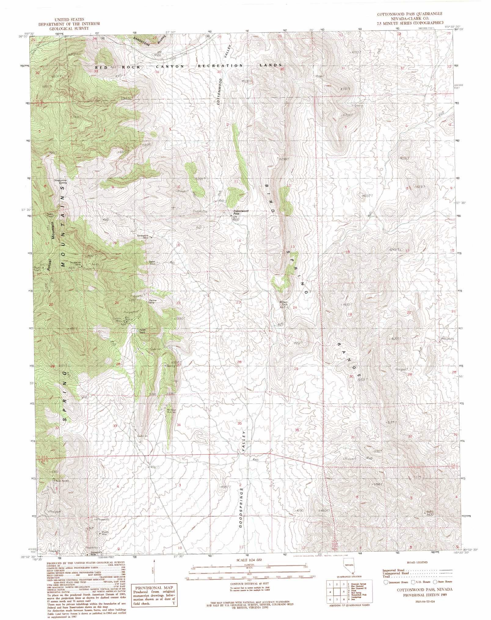
Cottonwood Pass Topo Map Nevada
To zoom in, hover over the map of Cottonwood Pass
USGS Topo Quad 35115h4 - 1:24,000 scale
| Topo Map Name: | Cottonwood Pass |
| USGS Topo Quad ID: | 35115h4 |
| Print Size: | ca. 21 1/4" wide x 27" high |
| Southeast Coordinates: | 35.875° N latitude / 115.375° W longitude |
| Map Center Coordinates: | 35.9375° N latitude / 115.4375° W longitude |
| U.S. State: | NV |
| Filename: | o35115h4.jpg |
| Download Map JPG Image: | Cottonwood Pass topo map 1:24,000 scale |
| Map Type: | Topographic |
| Topo Series: | 7.5´ |
| Map Scale: | 1:24,000 |
| Source of Map Images: | United States Geological Survey (USGS) |
| Alternate Map Versions: |
Cottonwood Pass NV 1989, updated 1990 Download PDF Buy paper map Cottonwood Pass NV 2012 Download PDF Buy paper map Cottonwood Pass NV 2015 Download PDF Buy paper map |
| FStopo: | US Forest Service topo Cottonwood Pass is available: Download FStopo PDF Download FStopo TIF |
1:24,000 Topo Quads surrounding Cottonwood Pass
Griffith Peak |
La Madre Spring |
La Madre Mountain |
Blue Diamond Ne |
Las Vegas Nw |
Lost Cabin Spring |
Mountain Springs |
Blue Diamond |
Blue Diamond Se |
Las Vegas Sw |
Green Monster Mine |
Potosi |
Cottonwood Pass |
Bird Spring |
Sloan |
West Of Shenandoah Peak |
Shenandoah Peak |
Goodsprings |
Jean |
Hidden Valley |
Mesquite Mountain |
Mesquite Lake |
State Line Pass |
Roach |
Mccullough Pass |
> Back to 35115e1 at 1:100,000 scale
> Back to 35114a1 at 1:250,000 scale
> Back to U.S. Topo Maps home
Cottonwood Pass topo map: Gazetteer
Cottonwood Pass: Gaps
Cottonwood Pass elevation 1504m 4934′Cottonwood Pass: Mines
Bluejay Mine elevation 1388m 4553′Contact Mine elevation 1725m 5659′
Dawn Mine elevation 1670m 5479′
Double Up Mine elevation 2242m 7355′
Ninetynine Mine elevation 1714m 5623′
Pauline Mine elevation 1725m 5659′
Rainbow Quarries elevation 1395m 4576′
Red Bluff Mine elevation 1646m 5400′
Snowstorm Mine elevation 1465m 4806′
Cottonwood Pass: Ranges
Bird Spring Range elevation 1511m 4957′Cottonwood Pass: Reservoirs
Aztec Tank elevation 1627m 5337′Wilson Tank elevation 1326m 4350′
Cottonwood Pass: Springs
Hampton Spring elevation 1587m 5206′Ninetynine Spring elevation 2057m 6748′
Wilson Spring elevation 1339m 4393′
Cottonwood Pass digital topo map on disk
Buy this Cottonwood Pass topo map showing relief, roads, GPS coordinates and other geographical features, as a high-resolution digital map file on DVD:
Southern Sierra Nevada, California & Southern Nevada
Buy digital topo maps: Southern Sierra Nevada, California & Southern Nevada