Soda Lake North Topo Map California
To zoom in, hover over the map of Soda Lake North
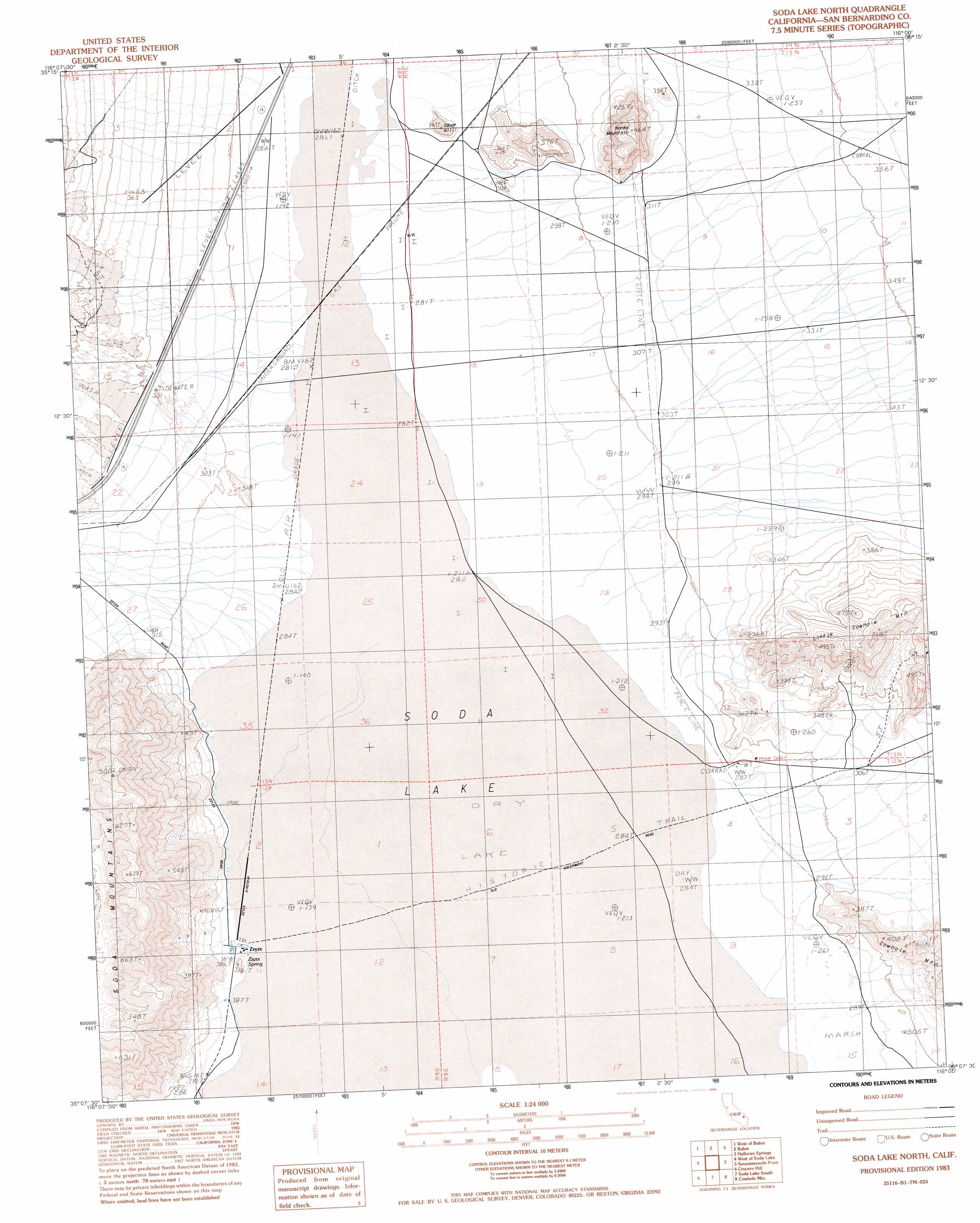
USGS Topo Quad 35116b1 - 1:24,000 scale
| Topo Map Name: | Soda Lake North |
| USGS Topo Quad ID: | 35116b1 |
| Print Size: | ca. 21 1/4" wide x 27" high |
| Southeast Coordinates: | 35.125° N latitude / 116° W longitude |
| Map Center Coordinates: | 35.1875° N latitude / 116.0625° W longitude |
| U.S. State: | CA |
| Filename: | o35116b1.jpg |
| Download Map JPG Image: | Soda Lake North topo map 1:24,000 scale |
| Map Type: | Topographic |
| Topo Series: | 7.5´ |
| Map Scale: | 1:24,000 |
| Source of Map Images: | United States Geological Survey (USGS) |
| Alternate Map Versions: |
Soda Lake North CA 1983, updated 1984 Download PDF Buy paper map Soda Lake North CA 1983, updated 1986 Download PDF Buy paper map Soda Lake North CA 2012 Download PDF Buy paper map Soda Lake North CA 2015 Download PDF Buy paper map |
1:24,000 Topo Quads surrounding Soda Lake North
Red Pass Lake Ne |
Silurian Valley |
North Of Baker |
Turquoise Mountain |
Solomons Knob |
Red Pass Lake |
West Of Baker |
Baker |
Halloran Spring |
Granite Spring |
Cronise Lakes |
West Of Soda Lake |
Soda Lake North |
Seventeenmile Point |
Indian Spring |
Cave Mountain |
Crucero Hill |
Soda Lake South |
Cowhole Mountain |
Old Dad Mountain |
Hidden Valley East |
West Of Broadwell Mesa |
Broadwell Mesa |
West Of Glasgow |
Glasgow |
> Back to 35116a1 at 1:100,000 scale
> Back to 35116a1 at 1:250,000 scale
> Back to U.S. Topo Maps home
Soda Lake North topo map: Gazetteer
Soda Lake North: Airports
Zzyzx Airstrip elevation 289m 948′Soda Lake North: Flats
Shortz Lake elevation 291m 954′Soda Lake elevation 288m 944′
Soda Lake North: Parks
Luckie Park elevation 290m 951′Soda Lake North: Populated Places
Zzyzx elevation 290m 951′Soda Lake North: Springs
Mesquite Spring elevation 286m 938′Zzyzx Spring elevation 289m 948′
Soda Lake North: Summits
Campbell Hill elevation 296m 971′Chocolate Drop elevation 287m 941′
Donnell Hill elevation 289m 948′
Hanks Mountain elevation 461m 1512′
Little Cowhole Mountain elevation 510m 1673′
Noels Knoll elevation 480m 1574′
Squat Hill elevation 343m 1125′
Soda Lake North digital topo map on disk
Buy this Soda Lake North topo map showing relief, roads, GPS coordinates and other geographical features, as a high-resolution digital map file on DVD:
Southern Sierra Nevada, California & Southern Nevada
Buy digital topo maps: Southern Sierra Nevada, California & Southern Nevada