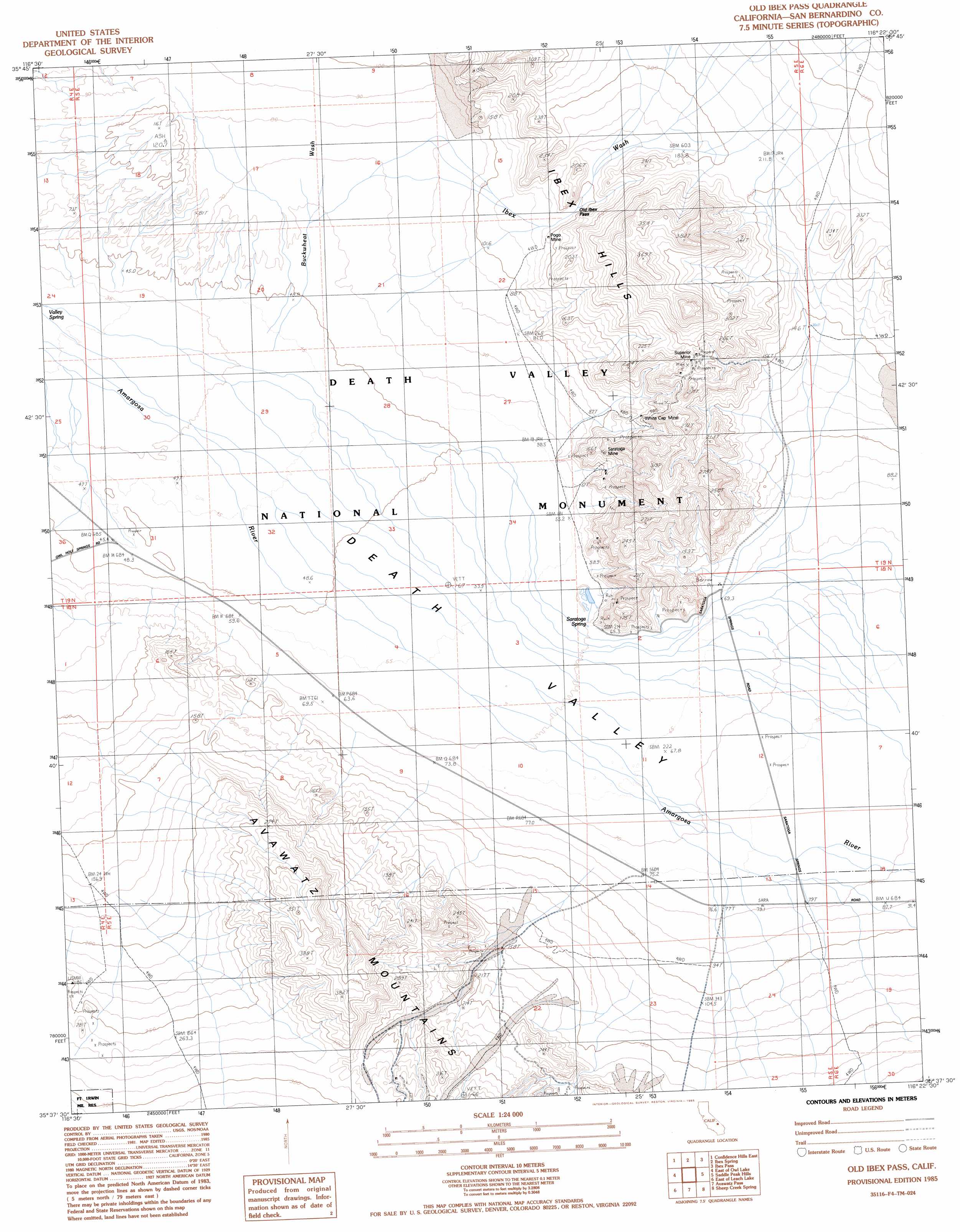
Old Ibex Pass Topo Map California
To zoom in, hover over the map of Old Ibex Pass
USGS Topo Quad 35116f4 - 1:24,000 scale
| Topo Map Name: | Old Ibex Pass |
| USGS Topo Quad ID: | 35116f4 |
| Print Size: | ca. 21 1/4" wide x 27" high |
| Southeast Coordinates: | 35.625° N latitude / 116.375° W longitude |
| Map Center Coordinates: | 35.6875° N latitude / 116.4375° W longitude |
| U.S. State: | CA |
| Filename: | o35116f4.jpg |
| Download Map JPG Image: | Old Ibex Pass topo map 1:24,000 scale |
| Map Type: | Topographic |
| Topo Series: | 7.5´ |
| Map Scale: | 1:24,000 |
| Source of Map Images: | United States Geological Survey (USGS) |
| Alternate Map Versions: |
Old Ibex Pass CA 1985, updated 1985 Download PDF Buy paper map Old Ibex Pass CA 1996, updated 1999 Download PDF Buy paper map Old Ibex Pass CA 2012 Download PDF Buy paper map Old Ibex Pass CA 2015 Download PDF Buy paper map |
1:24,000 Topo Quads surrounding Old Ibex Pass
Shore Line Butte |
Epaulet Peak |
Salsberry Peak |
Shoshone |
Resting Spring |
Confidence Hills West |
Confidence Hills East |
Ibex Spring |
Ibex Pass |
Tecopa |
Owl Lake |
East Of Owl Lake |
Old Ibex Pass |
Saddle Peak Hills |
Dumont Dunes |
Leach Lake |
East Of Leach Lake |
Avawatz Pass |
Sheep Creek Spring |
Silurian Lake |
West Of Drinkwater Lake |
Drinkwater Lake |
Red Pass Lake Nw |
Red Pass Lake Ne |
Silurian Valley |
> Back to 35116e1 at 1:100,000 scale
> Back to 35116a1 at 1:250,000 scale
> Back to U.S. Topo Maps home
Old Ibex Pass topo map: Gazetteer
Old Ibex Pass: Gaps
Old Ibex Pass elevation 149m 488′Old Ibex Pass: Mines
Pogo Mine elevation 126m 413′Saratoga Mine elevation 133m 436′
Superior Mine elevation 201m 659′
White Cap Mine elevation 121m 396′
Old Ibex Pass: Springs
Saratoga Spring elevation 60m 196′Old Ibex Pass: Streams
Buckwheat Wash elevation 41m 134′Ibex Wash elevation 59m 193′
Old Ibex Pass digital topo map on disk
Buy this Old Ibex Pass topo map showing relief, roads, GPS coordinates and other geographical features, as a high-resolution digital map file on DVD:
Southern Sierra Nevada, California & Southern Nevada
Buy digital topo maps: Southern Sierra Nevada, California & Southern Nevada