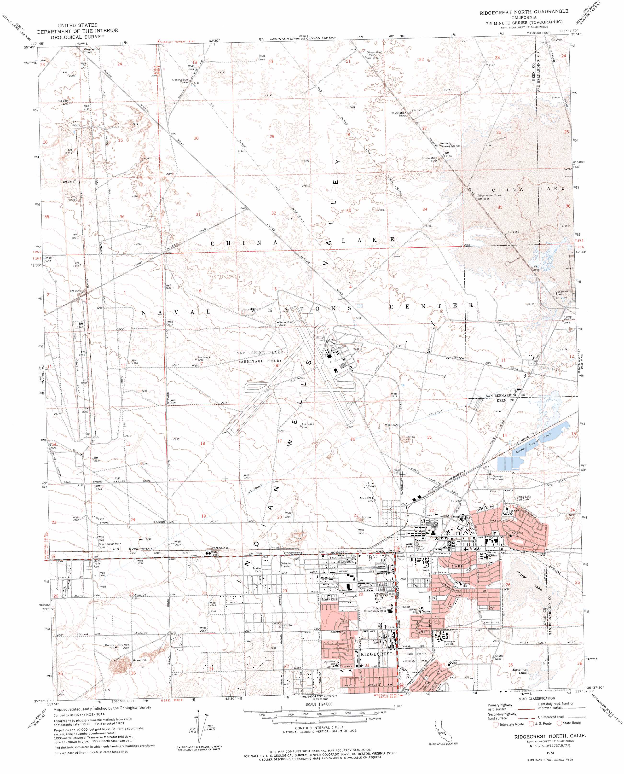
Ridgecrest North Topo Map California
To zoom in, hover over the map of Ridgecrest North
USGS Topo Quad 35117f6 - 1:24,000 scale
| Topo Map Name: | Ridgecrest North |
| USGS Topo Quad ID: | 35117f6 |
| Print Size: | ca. 21 1/4" wide x 27" high |
| Southeast Coordinates: | 35.625° N latitude / 117.625° W longitude |
| Map Center Coordinates: | 35.6875° N latitude / 117.6875° W longitude |
| U.S. State: | CA |
| Filename: | o35117f6.jpg |
| Download Map JPG Image: | Ridgecrest North topo map 1:24,000 scale |
| Map Type: | Topographic |
| Topo Series: | 7.5´ |
| Map Scale: | 1:24,000 |
| Source of Map Images: | United States Geological Survey (USGS) |
| Alternate Map Versions: |
Ridgecrest North CA 1973, updated 1976 Download PDF Buy paper map Ridgecrest North CA 2012 Download PDF Buy paper map Ridgecrest North CA 2015 Download PDF Buy paper map |
1:24,000 Topo Quads surrounding Ridgecrest North
Little Lake |
Volcano Peak |
Airport Lake |
Mountain Springs Canyon |
Homewood Canyon |
Ninemile Canyon |
Pearsonville |
White Hills |
Burro Canyon |
Trona West |
Owens Peak |
Inyokern |
Ridgecrest North |
Lone Butte |
Westend |
Freeman Junction |
Inyokern Se |
Ridgecrest South |
Spangler Hills West |
Spangler Hills East |
Saltdale Nw |
Garlock |
El Paso Peaks |
Klinker Mountain |
West Of Black Hills |
> Back to 35117e1 at 1:100,000 scale
> Back to 35116a1 at 1:250,000 scale
> Back to U.S. Topo Maps home
Ridgecrest North topo map: Gazetteer
Ridgecrest North: Airports
Ridgecrest Community Hospital Heliport elevation 697m 2286′Ridgecrest North: Flats
Mirror Lake elevation 684m 2244′Ridgecrest North: Lakes
Satellite Lake elevation 686m 2250′Ridgecrest North: Parks
Kern County Regional Park elevation 699m 2293′Pearson Park elevation 703m 2306′
Ridgecrest North: Populated Places
China Lake elevation 690m 2263′Ridgecrest North: Post Offices
Ridgecrest Post Office elevation 700m 2296′Ridgecrest North: Streams
Little Dixie Wash elevation 674m 2211′Ridgecrest North: Trails
C- 2 Flight Line elevation 667m 2188′C- 3 Flight Line elevation 677m 2221′
Old Flight Line Trail elevation 664m 2178′
Ridgecrest North: Valleys
Indian Wells Valley elevation 667m 2188′Ridgecrest North digital topo map on disk
Buy this Ridgecrest North topo map showing relief, roads, GPS coordinates and other geographical features, as a high-resolution digital map file on DVD:
Southern Sierra Nevada, California & Southern Nevada
Buy digital topo maps: Southern Sierra Nevada, California & Southern Nevada