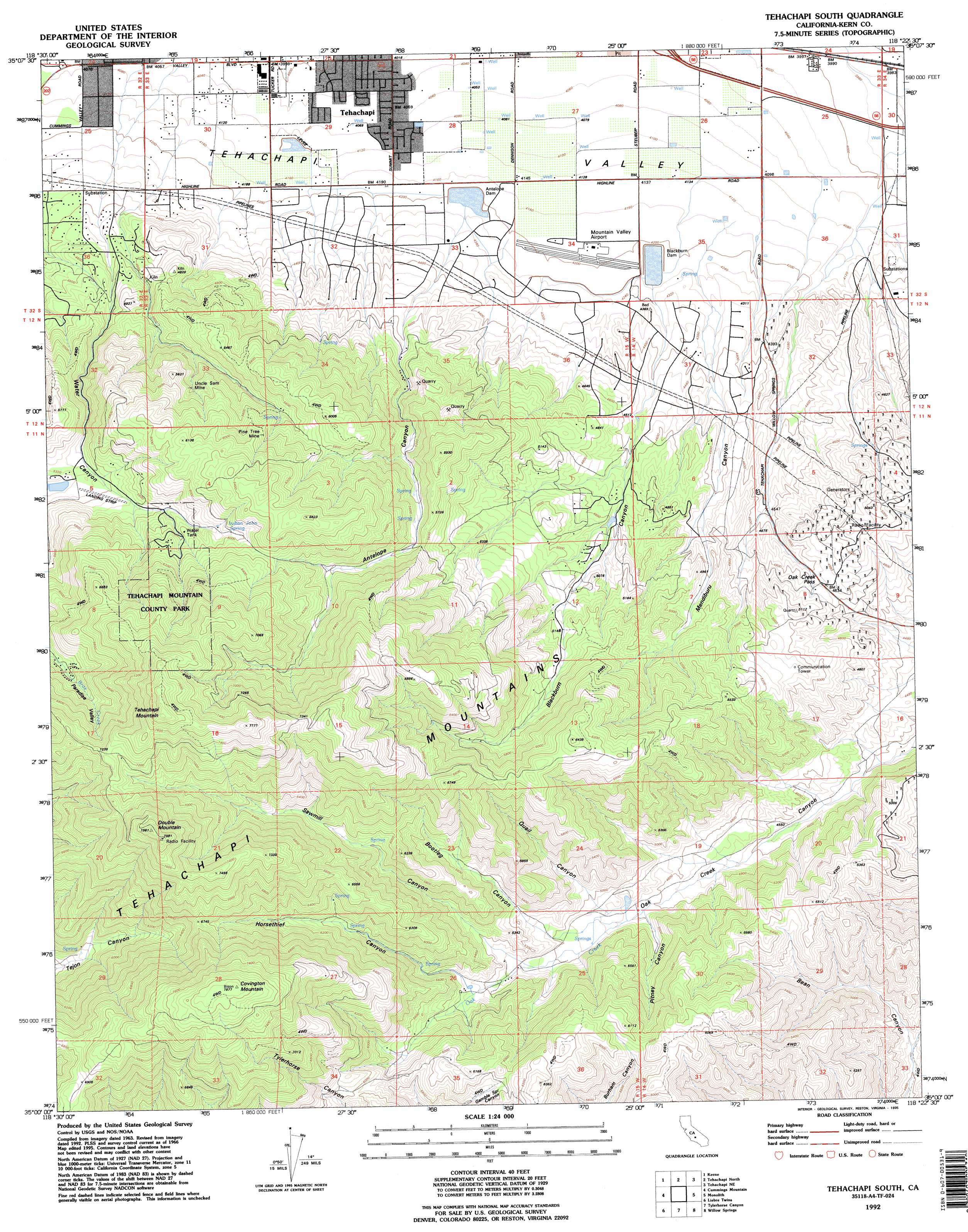
Tehachapi South Topo Map California
To zoom in, hover over the map of Tehachapi South
USGS Topo Quad 35118a4 - 1:24,000 scale
| Topo Map Name: | Tehachapi South |
| USGS Topo Quad ID: | 35118a4 |
| Print Size: | ca. 21 1/4" wide x 27" high |
| Southeast Coordinates: | 35° N latitude / 118.375° W longitude |
| Map Center Coordinates: | 35.0625° N latitude / 118.4375° W longitude |
| U.S. State: | CA |
| Filename: | o35118a4.jpg |
| Download Map JPG Image: | Tehachapi South topo map 1:24,000 scale |
| Map Type: | Topographic |
| Topo Series: | 7.5´ |
| Map Scale: | 1:24,000 |
| Source of Map Images: | United States Geological Survey (USGS) |
| Alternate Map Versions: |
Tehachapi South CA 1966, updated 1976 Download PDF Buy paper map Tehachapi South CA 1992, updated 1995 Download PDF Buy paper map Tehachapi South CA 2012 Download PDF Buy paper map Tehachapi South CA 2015 Download PDF Buy paper map |
1:24,000 Topo Quads surrounding Tehachapi South
Bena |
Oiler Peak |
Loraine |
Emerald Mountain |
Cross Mountain |
Bear Mountain |
Keene |
Tehachapi North |
Tehachapi Ne |
Cache Peak |
Tejon Ranch |
Cummings Mountain |
Tehachapi South |
Monolith |
Mojave |
Winters Ridge |
Liebre Twins |
Tylerhorse Canyon |
Willow Springs |
Soledad Mountain |
La Liebre Ranch |
Neenach School |
Fairmont Butte |
Little Buttes |
Rosamond |
> Back to 35118a1 at 1:100,000 scale
> Back to 35118a1 at 1:250,000 scale
> Back to U.S. Topo Maps home
Tehachapi South topo map: Gazetteer
Tehachapi South: Airports
Fantasy Haven Airport elevation 1279m 4196′Mountain Valley Airport elevation 1279m 4196′
Tehachapi South: Gaps
Oak Creek Pass elevation 1476m 4842′Tehachapi South: Parks
Tehachapi Mountain Park elevation 1784m 5853′Tehachapi South: Reservoirs
Sherm Chitwood Reservoir elevation 1263m 4143′Tehachapi South: Springs
Indian John Spring elevation 1809m 5935′Tehachapi South: Summits
Covington Mountain elevation 2361m 7746′Double Mountain elevation 2430m 7972′
Tehachapi Mountain elevation 2418m 7933′
Tehachapi South: Valleys
Antelope Canyon elevation 1286m 4219′Blackburn Canyon elevation 1281m 4202′
Bootleg Canyon elevation 1517m 4977′
Horsethief Canyon elevation 1601m 5252′
Mendiburu Canyon elevation 1334m 4376′
Pitney Canyon elevation 1473m 4832′
Quail Canyon elevation 1501m 4924′
Sawmill Canyon elevation 1542m 5059′
Water Canyon elevation 1284m 4212′
Tehachapi South digital topo map on disk
Buy this Tehachapi South topo map showing relief, roads, GPS coordinates and other geographical features, as a high-resolution digital map file on DVD:
Southern Sierra Nevada, California & Southern Nevada
Buy digital topo maps: Southern Sierra Nevada, California & Southern Nevada