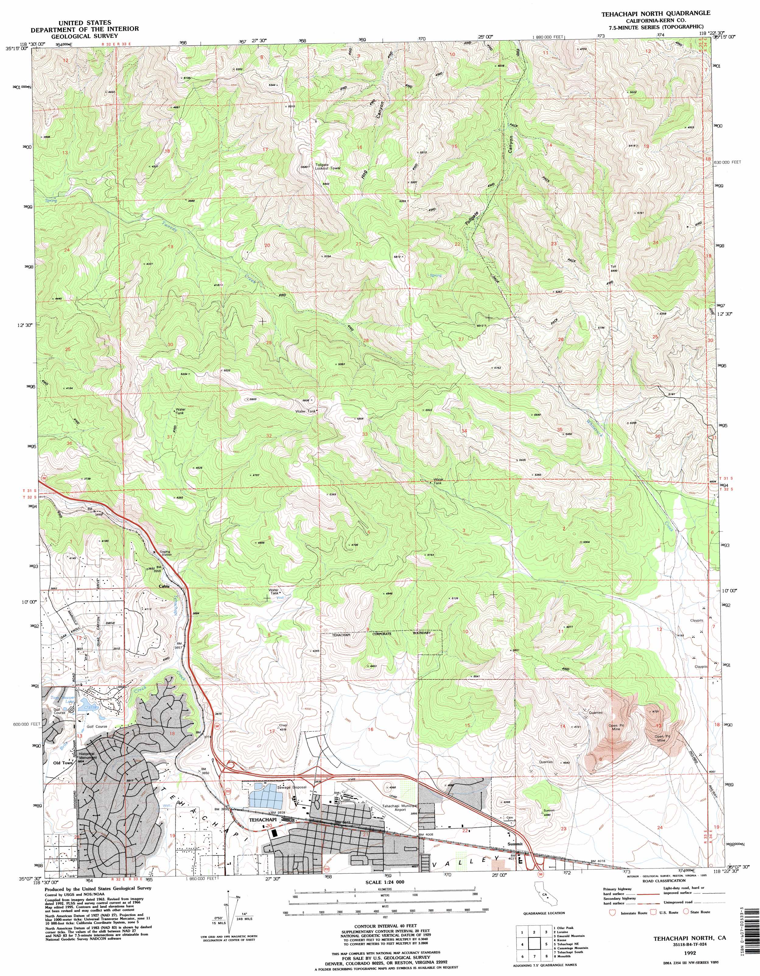
Tehachapi North Topo Map California
To zoom in, hover over the map of Tehachapi North
USGS Topo Quad 35118b4 - 1:24,000 scale
| Topo Map Name: | Tehachapi North |
| USGS Topo Quad ID: | 35118b4 |
| Print Size: | ca. 21 1/4" wide x 27" high |
| Southeast Coordinates: | 35.125° N latitude / 118.375° W longitude |
| Map Center Coordinates: | 35.1875° N latitude / 118.4375° W longitude |
| U.S. State: | CA |
| Filename: | o35118b4.jpg |
| Download Map JPG Image: | Tehachapi North topo map 1:24,000 scale |
| Map Type: | Topographic |
| Topo Series: | 7.5´ |
| Map Scale: | 1:24,000 |
| Source of Map Images: | United States Geological Survey (USGS) |
| Alternate Map Versions: |
Tehachapi North CA 1966, updated 1967 Download PDF Buy paper map Tehachapi North CA 1966, updated 1976 Download PDF Buy paper map Tehachapi North CA 1966, updated 1987 Download PDF Buy paper map Tehachapi North CA 1992, updated 1995 Download PDF Buy paper map Tehachapi North CA 2012 Download PDF Buy paper map Tehachapi North CA 2015 Download PDF Buy paper map |
1:24,000 Topo Quads surrounding Tehachapi North
Mount Adelaide |
Breckenridge Mountain |
Piute Peak |
Claraville |
Pinyon Mountain |
Bena |
Oiler Peak |
Loraine |
Emerald Mountain |
Cross Mountain |
Bear Mountain |
Keene |
Tehachapi North |
Tehachapi Ne |
Cache Peak |
Tejon Ranch |
Cummings Mountain |
Tehachapi South |
Monolith |
Mojave |
Winters Ridge |
Liebre Twins |
Tylerhorse Canyon |
Willow Springs |
Soledad Mountain |
> Back to 35118a1 at 1:100,000 scale
> Back to 35118a1 at 1:250,000 scale
> Back to U.S. Topo Maps home
Tehachapi North topo map: Gazetteer
Tehachapi North: Airports
Tehachapi Municipal Airport elevation 1213m 3979′Tehachapi North: Lakes
Tom Sawyer Lake elevation 1152m 3779′Tehachapi North: Parks
Meadowood Park elevation 1183m 3881′Old Town State Historic Landmark elevation 1166m 3825′
Tehachapi City Park elevation 1220m 4002′
West Park elevation 1213m 3979′
Tehachapi North: Populated Places
Cable elevation 1088m 3569′Golden Hills elevation 1194m 3917′
Old Town elevation 1167m 3828′
Sullivan (historical) elevation 1228m 4028′
Summit elevation 1231m 4038′
Tehachapi elevation 1210m 3969′
Tehachapi North: Post Offices
Tehachapi Post Office elevation 1214m 3982′Tehachapi North: Streams
Brite Creek elevation 1110m 3641′Whiterock Creek elevation 1276m 4186′
Tehachapi North digital topo map on disk
Buy this Tehachapi North topo map showing relief, roads, GPS coordinates and other geographical features, as a high-resolution digital map file on DVD:
Southern Sierra Nevada, California & Southern Nevada
Buy digital topo maps: Southern Sierra Nevada, California & Southern Nevada