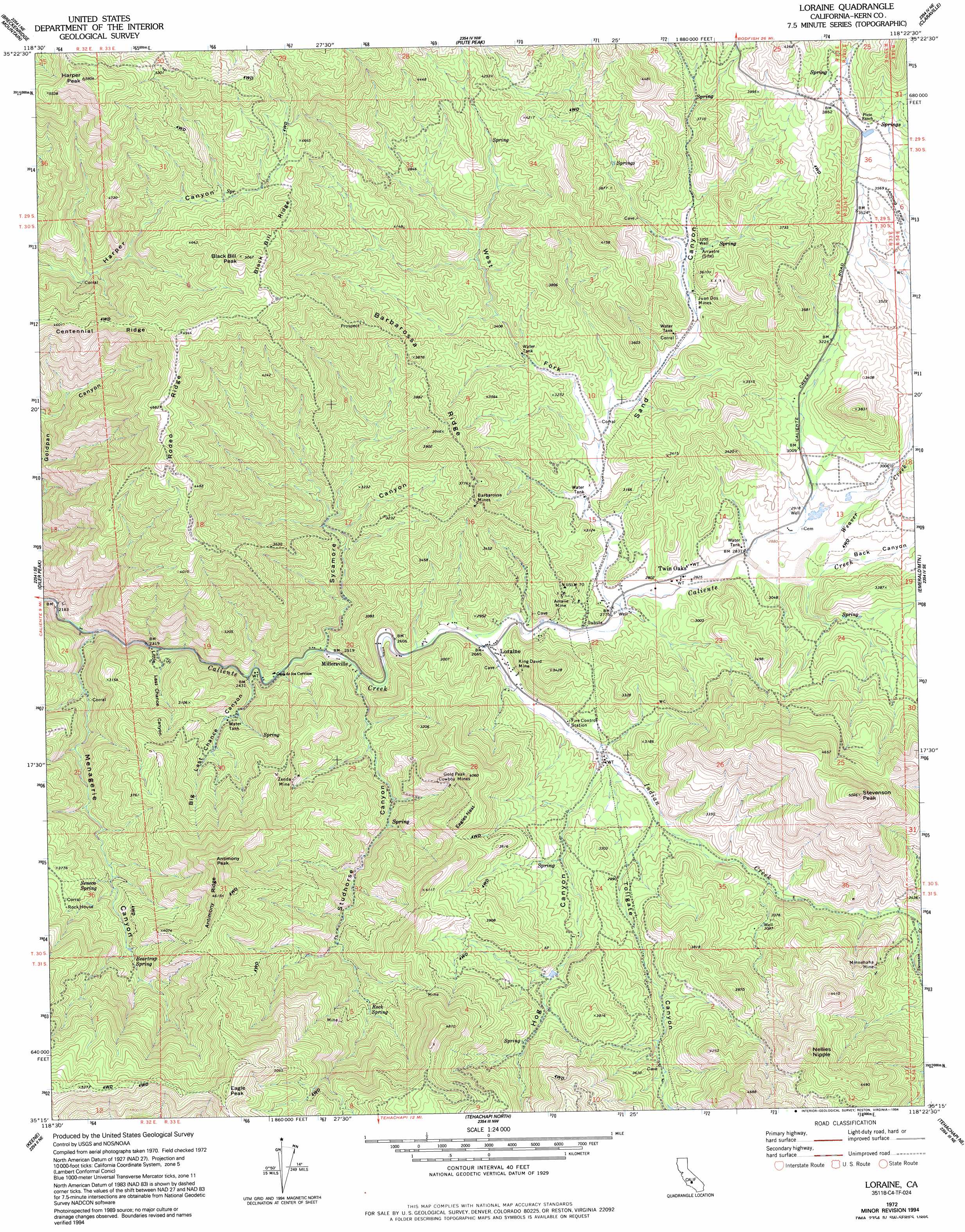
Loraine Topo Map California
To zoom in, hover over the map of Loraine
USGS Topo Quad 35118c4 - 1:24,000 scale
| Topo Map Name: | Loraine |
| USGS Topo Quad ID: | 35118c4 |
| Print Size: | ca. 21 1/4" wide x 27" high |
| Southeast Coordinates: | 35.25° N latitude / 118.375° W longitude |
| Map Center Coordinates: | 35.3125° N latitude / 118.4375° W longitude |
| U.S. State: | CA |
| Filename: | o35118c4.jpg |
| Download Map JPG Image: | Loraine topo map 1:24,000 scale |
| Map Type: | Topographic |
| Topo Series: | 7.5´ |
| Map Scale: | 1:24,000 |
| Source of Map Images: | United States Geological Survey (USGS) |
| Alternate Map Versions: |
Loraine CA 1972, updated 1975 Download PDF Buy paper map Loraine CA 1972, updated 1994 Download PDF Buy paper map Loraine CA 2012 Download PDF Buy paper map Loraine CA 2015 Download PDF Buy paper map |
1:24,000 Topo Quads surrounding Loraine
Democrat Hot Springs |
Miracle Hot Springs |
Lake Isabella South |
Woolstalf Creek |
Cane Canyon |
Mount Adelaide |
Breckenridge Mountain |
Piute Peak |
Claraville |
Pinyon Mountain |
Bena |
Oiler Peak |
Loraine |
Emerald Mountain |
Cross Mountain |
Bear Mountain |
Keene |
Tehachapi North |
Tehachapi Ne |
Cache Peak |
Tejon Ranch |
Cummings Mountain |
Tehachapi South |
Monolith |
Mojave |
> Back to 35118a1 at 1:100,000 scale
> Back to 35118a1 at 1:250,000 scale
> Back to U.S. Topo Maps home
Loraine topo map: Gazetteer
Loraine: Mines
Amalie Mine elevation 866m 2841′Barbarossa Mines elevation 1111m 3645′
Gold Peak Cowboy Mines elevation 1040m 3412′
Juan Dos Mines elevation 986m 3234′
King David Mine elevation 860m 2821′
Minnehaha Mine elevation 1096m 3595′
Zenda Mine elevation 1089m 3572′
Loraine: Populated Places
Loraine elevation 814m 2670′Millersville elevation 767m 2516′
Sand Canyon elevation 826m 2709′
Twin Oaks elevation 861m 2824′
Loraine: Ridges
Antimony Ridge elevation 1393m 4570′Barbarossa Ridge elevation 1163m 3815′
Black Bill Ridge elevation 1500m 4921′
Rodeo Ridge elevation 1426m 4678′
Loraine: Springs
Beartrap Spring elevation 1082m 3549′Rock Spring elevation 1095m 3592′
Seneca Spring elevation 1023m 3356′
Loraine: Streams
Hog Creek elevation 841m 2759′Indian Creek elevation 809m 2654′
Stevenson Creek elevation 957m 3139′
Studhorse Creek elevation 767m 2516′
Sycamore Creek elevation 758m 2486′
Weaver Creek elevation 878m 2880′
Loraine: Summits
Antimony Peak elevation 1412m 4632′Black Bill Peak elevation 1538m 5045′
Eagle Peak elevation 1670m 5479′
Eagles Nest elevation 1201m 3940′
Harper Peak elevation 1767m 5797′
Nellies Nipple elevation 1390m 4560′
Stevenson Peak elevation 1527m 5009′
Loraine: Valleys
Back Canyon elevation 878m 2880′Big Last Chance Canyon elevation 741m 2431′
Hog Canyon elevation 847m 2778′
Little Last Chance Canyon elevation 721m 2365′
Menagerie Canyon elevation 694m 2276′
Sand Canyon elevation 845m 2772′
Studhorse Canyon elevation 767m 2516′
Sycamore Canyon elevation 767m 2516′
Tollgate Canyon elevation 850m 2788′
West Fork Sand Canyon elevation 913m 2995′
Loraine digital topo map on disk
Buy this Loraine topo map showing relief, roads, GPS coordinates and other geographical features, as a high-resolution digital map file on DVD:
Southern Sierra Nevada, California & Southern Nevada
Buy digital topo maps: Southern Sierra Nevada, California & Southern Nevada