Lamont Topo Map California
To zoom in, hover over the map of Lamont
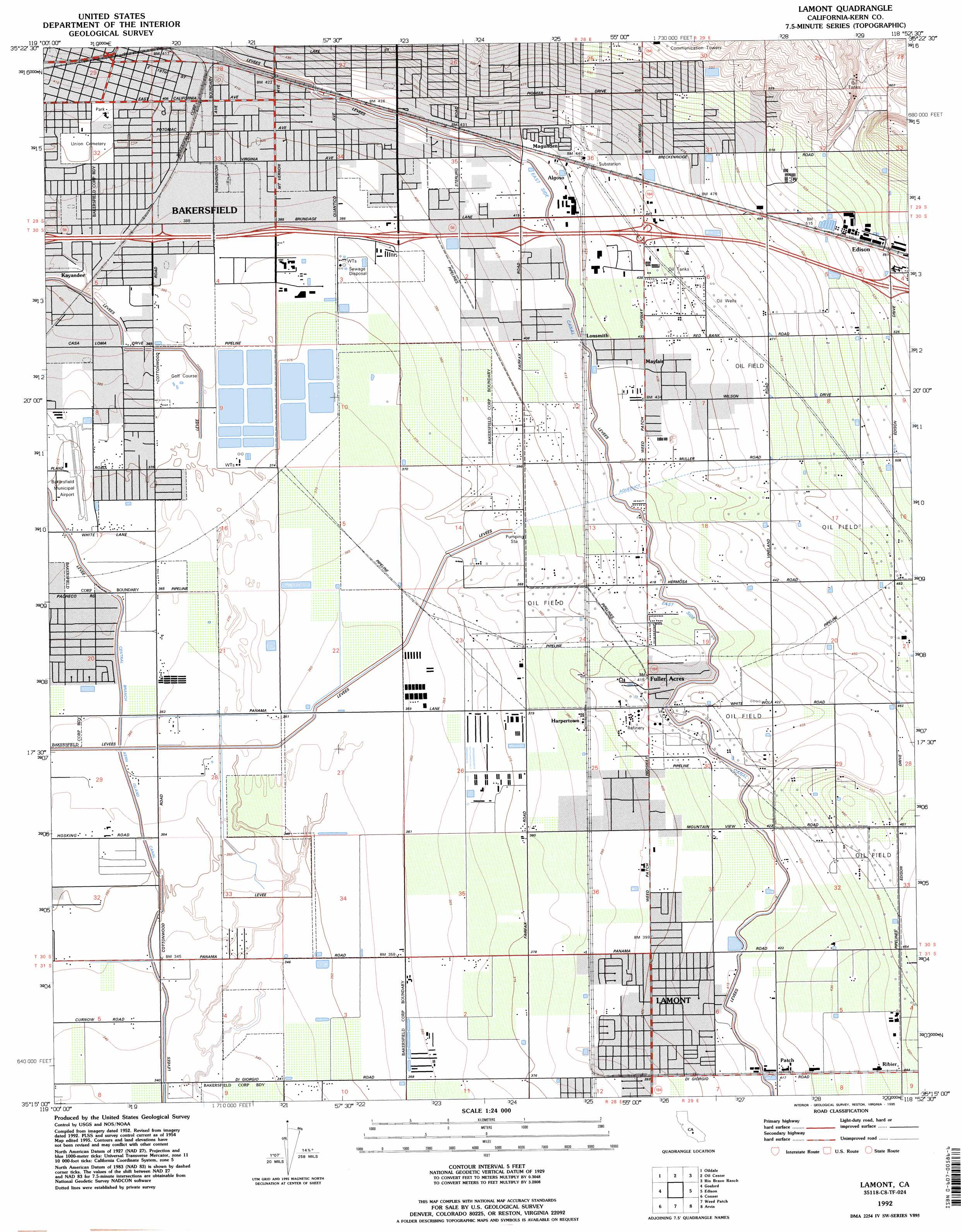
USGS Topo Quad 35118c8 - 1:24,000 scale
| Topo Map Name: | Lamont |
| USGS Topo Quad ID: | 35118c8 |
| Print Size: | ca. 21 1/4" wide x 27" high |
| Southeast Coordinates: | 35.25° N latitude / 118.875° W longitude |
| Map Center Coordinates: | 35.3125° N latitude / 118.9375° W longitude |
| U.S. State: | CA |
| Filename: | o35118c8.jpg |
| Download Map JPG Image: | Lamont topo map 1:24,000 scale |
| Map Type: | Topographic |
| Topo Series: | 7.5´ |
| Map Scale: | 1:24,000 |
| Source of Map Images: | United States Geological Survey (USGS) |
| Alternate Map Versions: |
Fairfax School CA 1950, updated 1950 Download PDF Buy paper map Lamont CA 1954, updated 1955 Download PDF Buy paper map Lamont CA 1954, updated 1970 Download PDF Buy paper map Lamont CA 1954, updated 1976 Download PDF Buy paper map Lamont CA 1978, updated 1981 Download PDF Buy paper map Lamont CA 1992, updated 1995 Download PDF Buy paper map Lamont CA 2012 Download PDF Buy paper map Lamont CA 2015 Download PDF Buy paper map |
1:24,000 Topo Quads surrounding Lamont
Famoso |
North Of Oildale |
Knob Hill |
Pine Mountain |
Democrat Hot Springs |
Rosedale |
Oildale |
Oil Center |
Rio Bravo Ranch |
Mount Adelaide |
Stevens |
Gosford |
Lamont |
Edison |
Bena |
Millux |
Conner |
Weed Patch |
Arvin |
Bear Mountain |
Conner Sw |
Coal Oil Canyon |
Mettler |
Tejon Hills |
Tejon Ranch |
> Back to 35118a1 at 1:100,000 scale
> Back to 35118a1 at 1:250,000 scale
> Back to U.S. Topo Maps home
Lamont topo map: Gazetteer
Lamont: Airports
Bakersfield Municipal Airport elevation 115m 377′Lamont: Canals
Central Branch Kern Island Canal elevation 111m 364′East Side Canal elevation 128m 419′
Lamont: Dams
Irrigation Reservoir 2011-002 Dam elevation 115m 377′Lamont: Parks
Belle Terrace Park elevation 119m 390′Casa Loma County Park elevation 118m 387′
Lamont Park elevation 123m 403′
Mayflower Park elevation 124m 406′
Orangewood Park elevation 172m 564′
Oswell Park elevation 123m 403′
Pioneer County Park elevation 140m 459′
Potomac County Park elevation 125m 410′
Rexland Acres Park elevation 111m 364′
Virginia Avenue County Park elevation 122m 400′
Lamont: Populated Places
Algoso elevation 131m 429′Fuller Acres elevation 128m 419′
Harpertown elevation 121m 396′
Kayandee elevation 121m 396′
Lamont elevation 123m 403′
Lonsmith elevation 129m 423′
Magunden elevation 134m 439′
Mayfair elevation 133m 436′
Patch elevation 128m 419′
Ribier elevation 136m 446′
Lamont: Post Offices
Lamont Post Office elevation 123m 403′Lamont digital topo map on disk
Buy this Lamont topo map showing relief, roads, GPS coordinates and other geographical features, as a high-resolution digital map file on DVD:
Southern Sierra Nevada, California & Southern Nevada
Buy digital topo maps: Southern Sierra Nevada, California & Southern Nevada