Carneros Rocks Topo Map California
To zoom in, hover over the map of Carneros Rocks
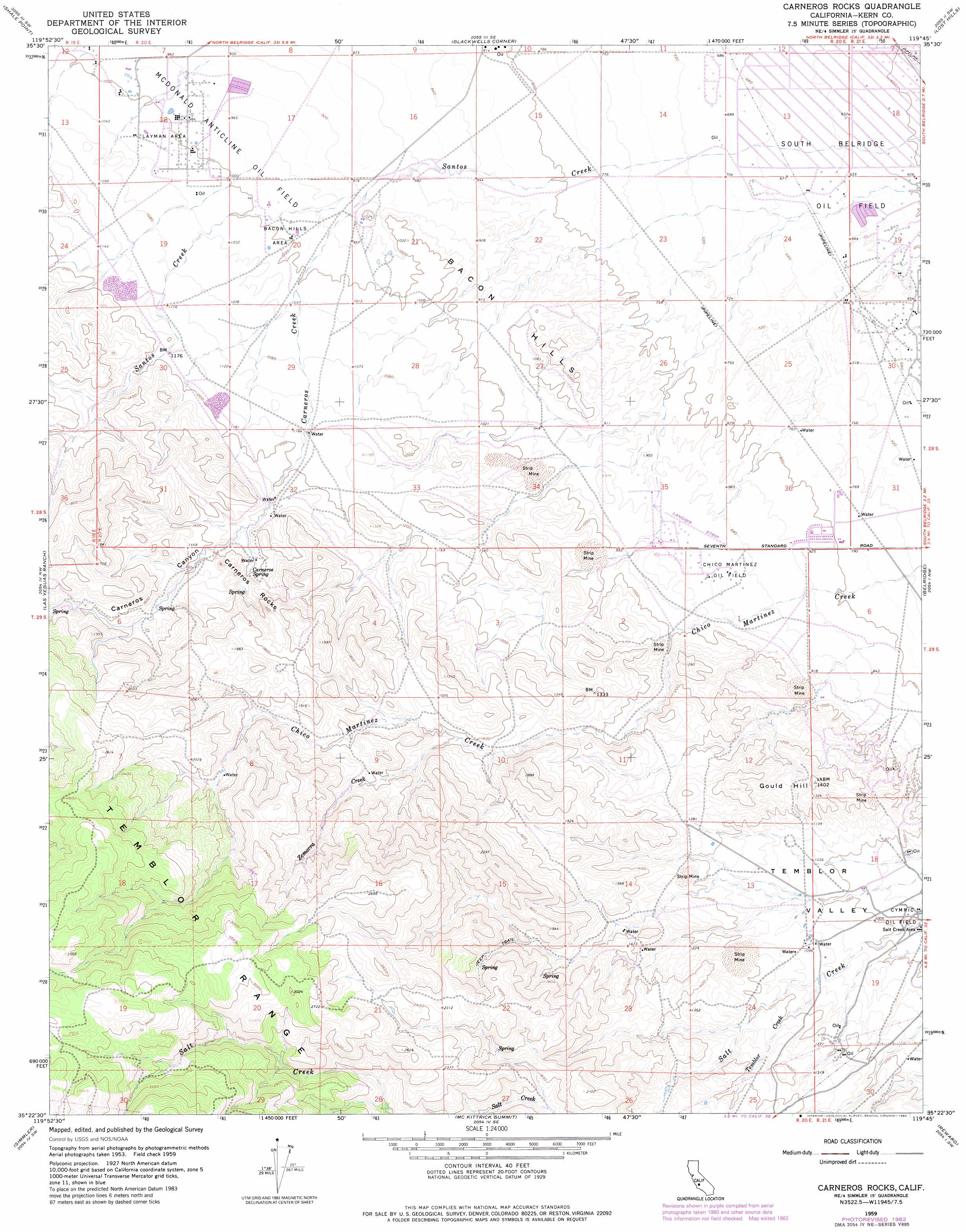
USGS Topo Quad 35119d7 - 1:24,000 scale
| Topo Map Name: | Carneros Rocks |
| USGS Topo Quad ID: | 35119d7 |
| Print Size: | ca. 21 1/4" wide x 27" high |
| Southeast Coordinates: | 35.375° N latitude / 119.75° W longitude |
| Map Center Coordinates: | 35.4375° N latitude / 119.8125° W longitude |
| U.S. State: | CA |
| Filename: | o35119d7.jpg |
| Download Map JPG Image: | Carneros Rocks topo map 1:24,000 scale |
| Map Type: | Topographic |
| Topo Series: | 7.5´ |
| Map Scale: | 1:24,000 |
| Source of Map Images: | United States Geological Survey (USGS) |
| Alternate Map Versions: |
Carneros Rocks CA 1959, updated 1961 Download PDF Buy paper map Carneros Rocks CA 1959, updated 1976 Download PDF Buy paper map Carneros Rocks CA 1959, updated 1976 Download PDF Buy paper map Carneros Rocks CA 1959, updated 1982 Download PDF Buy paper map Carneros Rocks CA 1959, updated 1982 Download PDF Buy paper map Carneros Rocks CA 2012 Download PDF Buy paper map Carneros Rocks CA 2015 Download PDF Buy paper map |
1:24,000 Topo Quads surrounding Carneros Rocks
Sawtooth Ridge |
Emigrant Hill |
Antelope Plain |
Lost Hills Nw |
Lost Hills Ne |
Packwood Creek |
Shale Point |
Blackwells Corner |
Lost Hills |
Semitropic |
La Panza Ne |
Las Yeguas Ranch |
Carneros Rocks |
Belridge |
Lokern |
California Valley |
Simmler |
Mckittrick Summit |
Reward |
West Elk Hills |
Branch Mountain |
Chimineas Ranch |
Painted Rock |
Panorama Hills |
Fellows |
> Back to 35119a1 at 1:100,000 scale
> Back to 35118a1 at 1:250,000 scale
> Back to U.S. Topo Maps home
Carneros Rocks topo map: Gazetteer
Carneros Rocks: Areas
Carneros Rocks elevation 465m 1525′Layman Area elevation 307m 1007′
Salt Creek Area elevation 295m 967′
Carneros Rocks: Oilfields
Chico Martinez Oil Field elevation 276m 905′Carneros Rocks: Ranges
Bacon Hills elevation 294m 964′Carneros Rocks: Springs
Carneros Spring elevation 424m 1391′Carneros Rocks: Streams
Carneros Creek elevation 281m 921′Santos Creek elevation 182m 597′
Temblor Creek elevation 331m 1085′
Zemorra Creek elevation 230m 754′
Carneros Rocks: Summits
Gould Hill elevation 431m 1414′Carneros Rocks: Valleys
Carneros Canyon elevation 401m 1315′Carneros Rocks digital topo map on disk
Buy this Carneros Rocks topo map showing relief, roads, GPS coordinates and other geographical features, as a high-resolution digital map file on DVD:
Southern Sierra Nevada, California & Southern Nevada
Buy digital topo maps: Southern Sierra Nevada, California & Southern Nevada