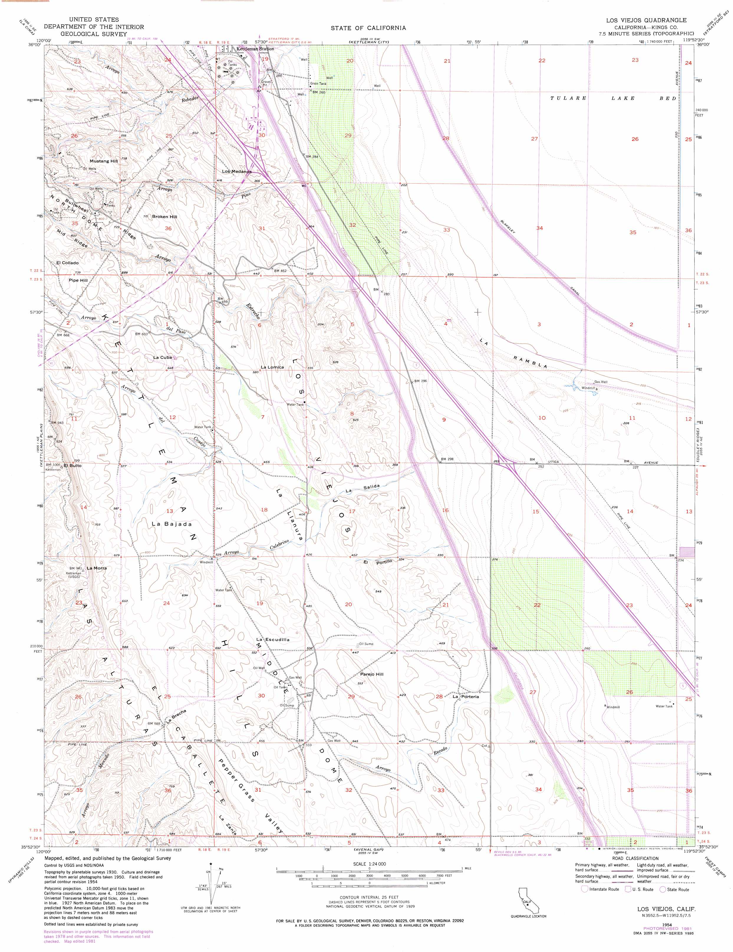
Los Viejos Topo Map California
To zoom in, hover over the map of Los Viejos
USGS Topo Quad 35119h8 - 1:24,000 scale
| Topo Map Name: | Los Viejos |
| USGS Topo Quad ID: | 35119h8 |
| Print Size: | ca. 21 1/4" wide x 27" high |
| Southeast Coordinates: | 35.875° N latitude / 119.875° W longitude |
| Map Center Coordinates: | 35.9375° N latitude / 119.9375° W longitude |
| U.S. State: | CA |
| Filename: | o35119h8.jpg |
| Download Map JPG Image: | Los Viejos topo map 1:24,000 scale |
| Map Type: | Topographic |
| Topo Series: | 7.5´ |
| Map Scale: | 1:24,000 |
| Source of Map Images: | United States Geological Survey (USGS) |
| Alternate Map Versions: |
Los Viejos CA 1954, updated 1956 Download PDF Buy paper map Los Viejos CA 1954, updated 1976 Download PDF Buy paper map Los Viejos CA 1954, updated 1982 Download PDF Buy paper map Los Viejos CA 2012 Download PDF Buy paper map Los Viejos CA 2015 Download PDF Buy paper map |
1:24,000 Topo Quads surrounding Los Viejos
Guijarral Hills |
Huron |
Westhaven |
Stratford |
Guernsey |
Avenal |
La Cima |
Kettleman City |
Stratford Se |
El Rico Ranch |
Garza Peak |
Kettleman Plain |
Los Viejos |
Dudley Ridge |
Hacienda Ranch Nw |
Tent Hills |
Pyramid Hills |
Avenal Gap |
West Camp |
Lone Tree Well |
Orchard Peak |
Sawtooth Ridge |
Emigrant Hill |
Antelope Plain |
Lost Hills Nw |
> Back to 35119e1 at 1:100,000 scale
> Back to 35118a1 at 1:250,000 scale
> Back to U.S. Topo Maps home
Los Viejos topo map: Gazetteer
Los Viejos: Basins
La Escudilla elevation 171m 561′Los Viejos: Flats
La Llanura elevation 124m 406′La Rambla elevation 68m 223′
Los Viejos: Gaps
El Portillo elevation 133m 436′La Brecha elevation 210m 688′
La Portería elevation 107m 351′
La Salida elevation 111m 364′
Los Viejos: Populated Places
Kettleman Station elevation 95m 311′Los Viejos: Ranges
Las Alturas elevation 175m 574′Los Viejos elevation 187m 613′
Los Viejos: Ridges
El Caballete elevation 231m 757′Los Médanos elevation 133m 436′
Mid Ridge elevation 245m 803′
Middle Dome elevation 205m 672′
Los Viejos: Slopes
La Bajada elevation 173m 567′Los Viejos: Streams
Arroyo Culebrino elevation 67m 219′Arroyo del Conejo elevation 132m 433′
Arroyo del Paso elevation 147m 482′
Arroyo Estrecho elevation 63m 206′
Arroyo Pino elevation 66m 216′
Arroyo Recodo elevation 107m 351′
Los Viejos: Summits
Broken Hill elevation 215m 705′El Bulto elevation 305m 1000′
El Collado elevation 248m 813′
La Cuba elevation 217m 711′
La Lomica elevation 159m 521′
La Morra elevation 285m 935′
Mustang Hill elevation 213m 698′
Parejo Hill elevation 161m 528′
Pipe Hill elevation 233m 764′
Los Viejos digital topo map on disk
Buy this Los Viejos topo map showing relief, roads, GPS coordinates and other geographical features, as a high-resolution digital map file on DVD:
Southern Sierra Nevada, California & Southern Nevada
Buy digital topo maps: Southern Sierra Nevada, California & Southern Nevada