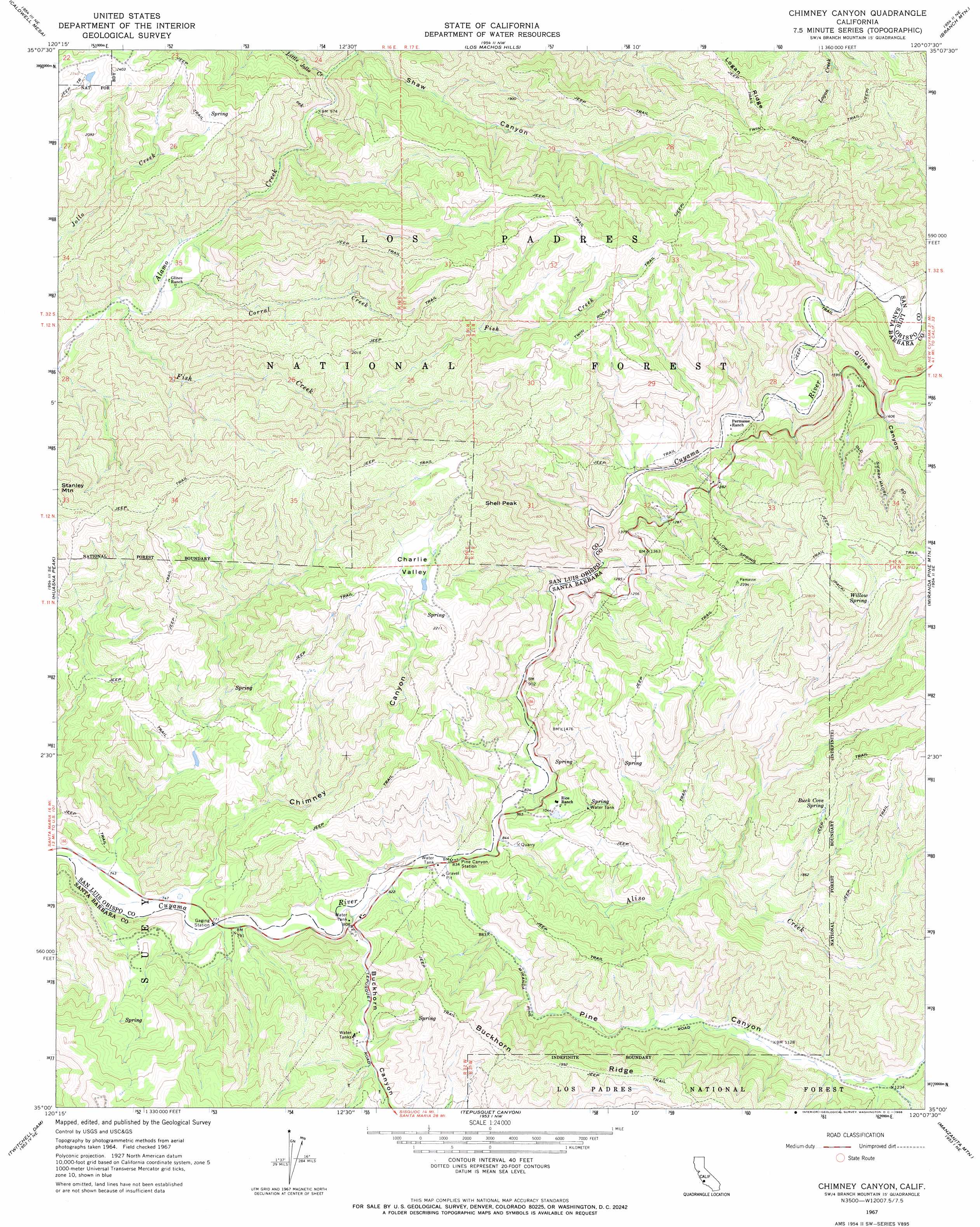
Chimney Canyon Topo Map California
To zoom in, hover over the map of Chimney Canyon
USGS Topo Quad 35120a2 - 1:24,000 scale
| Topo Map Name: | Chimney Canyon |
| USGS Topo Quad ID: | 35120a2 |
| Print Size: | ca. 21 1/4" wide x 27" high |
| Southeast Coordinates: | 35° N latitude / 120.125° W longitude |
| Map Center Coordinates: | 35.0625° N latitude / 120.1875° W longitude |
| U.S. State: | CA |
| Filename: | o35120a2.jpg |
| Download Map JPG Image: | Chimney Canyon topo map 1:24,000 scale |
| Map Type: | Topographic |
| Topo Series: | 7.5´ |
| Map Scale: | 1:24,000 |
| Source of Map Images: | United States Geological Survey (USGS) |
| Alternate Map Versions: |
Chimney Canyon CA 1967, updated 1968 Download PDF Buy paper map Chimney Canyon CA 1967, updated 1968 Download PDF Buy paper map Chimney Canyon CA 1977 Download PDF Buy paper map Chimney Canyon CA 1995, updated 2000 Download PDF Buy paper map Chimney Canyon CA 2012 Download PDF Buy paper map Chimney Canyon CA 2015 Download PDF Buy paper map |
| FStopo: | US Forest Service topo Chimney Canyon is available: Download FStopo PDF Download FStopo TIF |
1:24,000 Topo Quads surrounding Chimney Canyon
Santa Margarita Lake |
Pozo Summit |
La Panza |
California Valley |
Simmler |
Tar Spring Ridge |
Caldwell Mesa |
Los Machos Hills |
Branch Mountain |
Chimineas Ranch |
Nipomo |
Huasna Peak |
Chimney Canyon |
Miranda Pine Mountain |
Taylor Canyon |
Santa Maria |
Twitchell Dam |
Tepusquet Canyon |
Manzanita Mountain |
Bates Canyon |
Orcutt |
Sisquoc |
Foxen Canyon |
Zaca Lake |
Bald Mountain |
> Back to 35120a1 at 1:100,000 scale
> Back to 35120a1 at 1:250,000 scale
> Back to U.S. Topo Maps home
Chimney Canyon topo map: Gazetteer
Chimney Canyon: Springs
Buck Cove Spring elevation 636m 2086′Willow Spring elevation 758m 2486′
Chimney Canyon: Streams
Aliso Creek elevation 256m 839′Clear Creek elevation 348m 1141′
Corral Creek elevation 256m 839′
Fish Creek elevation 254m 833′
Little Jollo Creek elevation 304m 997′
Chimney Canyon: Summits
Shell Peak elevation 748m 2454′Chimney Canyon: Trails
Twin Rocks Trail elevation 729m 2391′Willow Spring Trail elevation 743m 2437′
Chimney Canyon: Valleys
Buckhorn Canyon elevation 244m 800′Charlie Valley elevation 603m 1978′
Chimney Canyon elevation 227m 744′
Glines Canyon elevation 334m 1095′
Horseshoe Canyon elevation 371m 1217′
Pine Canyon elevation 252m 826′
Shaw Canyon elevation 317m 1040′
Chimney Canyon digital topo map on disk
Buy this Chimney Canyon topo map showing relief, roads, GPS coordinates and other geographical features, as a high-resolution digital map file on DVD: