Wilson Corner Topo Map California
To zoom in, hover over the map of Wilson Corner
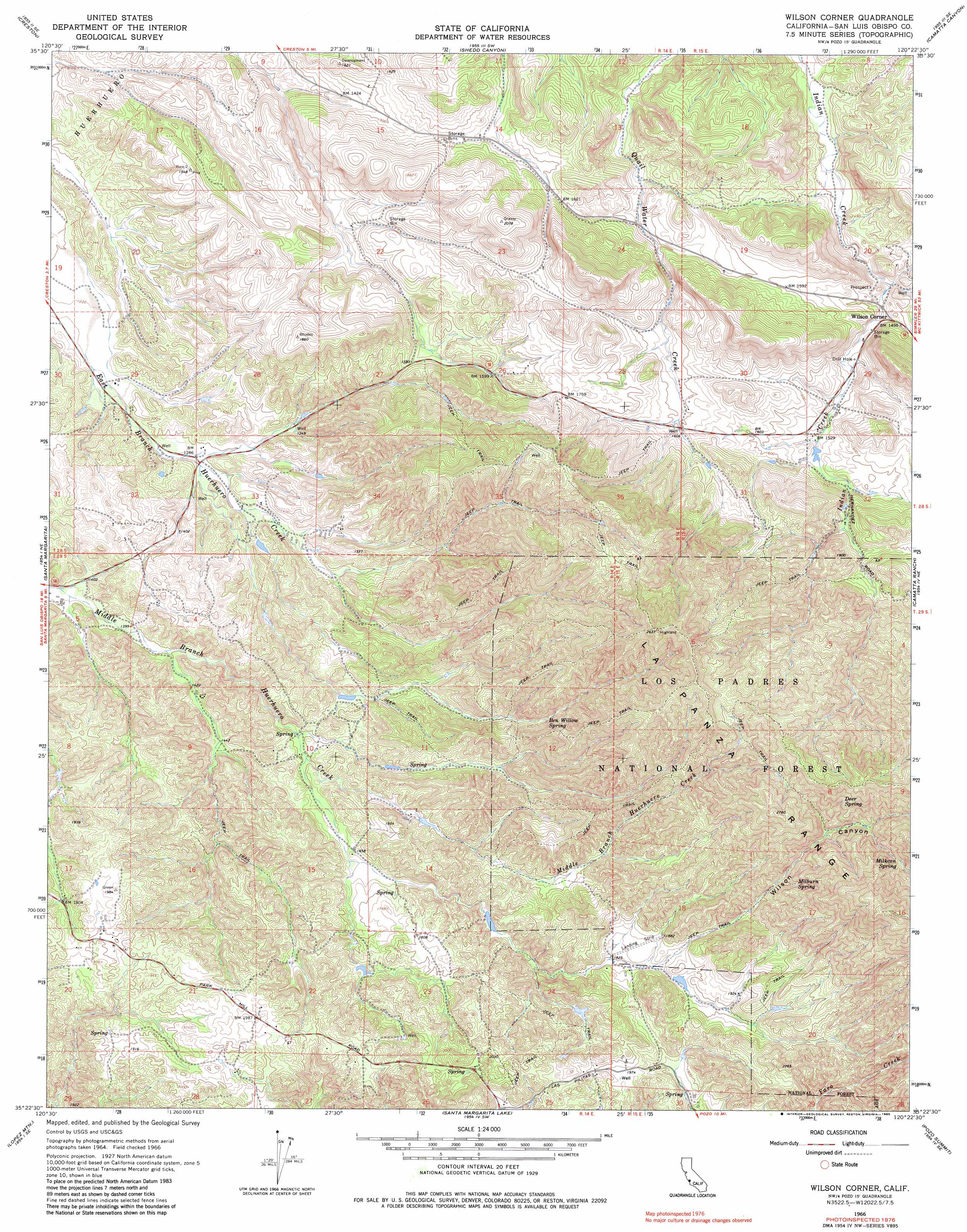
USGS Topo Quad 35120d4 - 1:24,000 scale
| Topo Map Name: | Wilson Corner |
| USGS Topo Quad ID: | 35120d4 |
| Print Size: | ca. 21 1/4" wide x 27" high |
| Southeast Coordinates: | 35.375° N latitude / 120.375° W longitude |
| Map Center Coordinates: | 35.4375° N latitude / 120.4375° W longitude |
| U.S. State: | CA |
| Filename: | o35120d4.jpg |
| Download Map JPG Image: | Wilson Corner topo map 1:24,000 scale |
| Map Type: | Topographic |
| Topo Series: | 7.5´ |
| Map Scale: | 1:24,000 |
| Source of Map Images: | United States Geological Survey (USGS) |
| Alternate Map Versions: |
Wilson Corner CA 1966, updated 1968 Download PDF Buy paper map Wilson Corner CA 1966, updated 1985 Download PDF Buy paper map Wilson Corner CA 1995, updated 2000 Download PDF Buy paper map Wilson Corner CA 2012 Download PDF Buy paper map Wilson Corner CA 2015 Download PDF Buy paper map |
| FStopo: | US Forest Service topo Wilson Corner is available: Download FStopo PDF Download FStopo TIF |
1:24,000 Topo Quads surrounding Wilson Corner
Paso Robles |
Estrella |
Shandon |
Cholame |
Orchard Peak |
Templeton |
Creston |
Shedd Canyon |
Camatta Canyon |
Holland Canyon |
Atascadero |
Santa Margarita |
Wilson Corner |
Camatta Ranch |
La Panza Ranch |
San Luis Obispo |
Lopez Mountain |
Santa Margarita Lake |
Pozo Summit |
La Panza |
Pismo Beach |
Arroyo Grande Ne |
Tar Spring Ridge |
Caldwell Mesa |
Los Machos Hills |
> Back to 35120a1 at 1:100,000 scale
> Back to 35120a1 at 1:250,000 scale
> Back to U.S. Topo Maps home
Wilson Corner topo map: Gazetteer
Wilson Corner: Populated Places
Wilson Corner elevation 450m 1476′Wilson Corner: Springs
Ben Willow Spring elevation 539m 1768′Deer Spring elevation 734m 2408′
Milburn Spring elevation 656m 2152′
Milkcan Spring elevation 742m 2434′
Wilson Corner: Valleys
Wilson Canyon elevation 561m 1840′Wilson Corner digital topo map on disk
Buy this Wilson Corner topo map showing relief, roads, GPS coordinates and other geographical features, as a high-resolution digital map file on DVD: