Pebblestone Shut-In Topo Map California
To zoom in, hover over the map of Pebblestone Shut-In
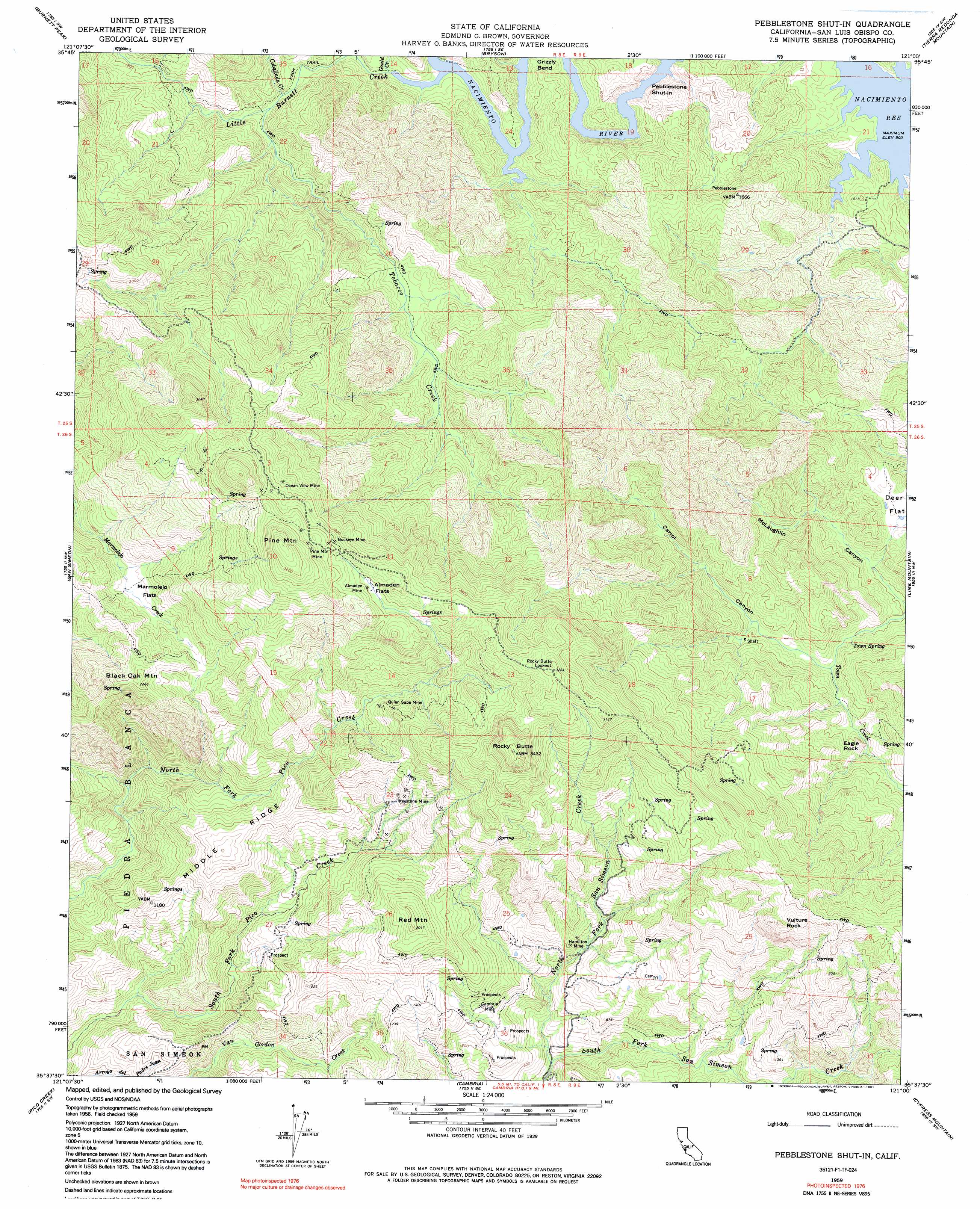
USGS Topo Quad 35121f1 - 1:24,000 scale
| Topo Map Name: | Pebblestone Shut-In |
| USGS Topo Quad ID: | 35121f1 |
| Print Size: | ca. 21 1/4" wide x 27" high |
| Southeast Coordinates: | 35.625° N latitude / 121° W longitude |
| Map Center Coordinates: | 35.6875° N latitude / 121.0625° W longitude |
| U.S. State: | CA |
| Filename: | o35121f1.jpg |
| Download Map JPG Image: | Pebblestone Shut-In topo map 1:24,000 scale |
| Map Type: | Topographic |
| Topo Series: | 7.5´ |
| Map Scale: | 1:24,000 |
| Source of Map Images: | United States Geological Survey (USGS) |
| Alternate Map Versions: |
Pebblestone Shut-In CA 1959, updated 1960 Download PDF Buy paper map Pebblestone Shut-In CA 1959, updated 1991 Download PDF Buy paper map Pebblestone Shut-In CA 1959, updated 1991 Download PDF Buy paper map Pebblestone Shut-in CA 2012 Download PDF Buy paper map Pebblestone Shut-in CA 2015 Download PDF Buy paper map |
1:24,000 Topo Quads surrounding Pebblestone Shut-In
Alder Peak |
Jolon |
Williams Hill |
Hames Valley |
Wunpost |
Burro Mountain |
Burnett Peak |
Bryson |
Tierra Redondo Mountain |
Bradley |
Piedras Blancas |
San Simeon |
Pebblestone Shut-In |
Lime Mountain |
Adelaida |
Pico Creek |
Cambria |
Cypress Mountain |
York Mountain |
|
Cayucos |
Morro Bay North |
> Back to 35121e1 at 1:100,000 scale
> Back to 35120a1 at 1:250,000 scale
> Back to U.S. Topo Maps home
Pebblestone Shut-In topo map: Gazetteer
Pebblestone Shut-In: Bends
Grizzly Bend elevation 337m 1105′Pebblestone Shut-In: Flats
Almaden Flats elevation 847m 2778′Deer Flat elevation 399m 1309′
Marmo-lejo Flats elevation 508m 1666′
Pebblestone Shut-In: Mines
Almaden Mine elevation 853m 2798′Buckeye Mine elevation 889m 2916′
Eucalyptus Lateral Ten elevation 287m 941′
Hamilton Mine elevation 259m 849′
Keystone Mine elevation 582m 1909′
Ocean View Mine elevation 832m 2729′
Pine Mountain Mine elevation 964m 3162′
Quien Sabe Mine elevation 597m 1958′
Pebblestone Shut-In: Ridges
Middle Ridge elevation 477m 1564′Pebblestone Shut-In: Springs
Town Spring elevation 330m 1082′Pebblestone Shut-In: Streams
Caballada Creek elevation 264m 866′Gould Creek elevation 248m 813′
Kavanaugh Creek elevation 245m 803′
Little Burnett Creek elevation 245m 803′
North Fork San Simeon Creek elevation 98m 321′
North Grizzly Bend Creek elevation 246m 807′
Tobacco Creek elevation 277m 908′
Pebblestone Shut-In: Summits
Black Oak Mountain elevation 688m 2257′Eagle Rock elevation 411m 1348′
Pebblestone Shut-in elevation 245m 803′
Pine Mountain elevation 1093m 3585′
Red Mountain elevation 623m 2043′
Rocky Butte elevation 1043m 3421′
Vulture Rock elevation 857m 2811′
Pebblestone Shut-In: Valleys
Carrol Canyon elevation 315m 1033′McLaughlin Canyon elevation 296m 971′
Pebblestone Shut-In digital topo map on disk
Buy this Pebblestone Shut-In topo map showing relief, roads, GPS coordinates and other geographical features, as a high-resolution digital map file on DVD: