San Simeon Topo Map California
To zoom in, hover over the map of San Simeon
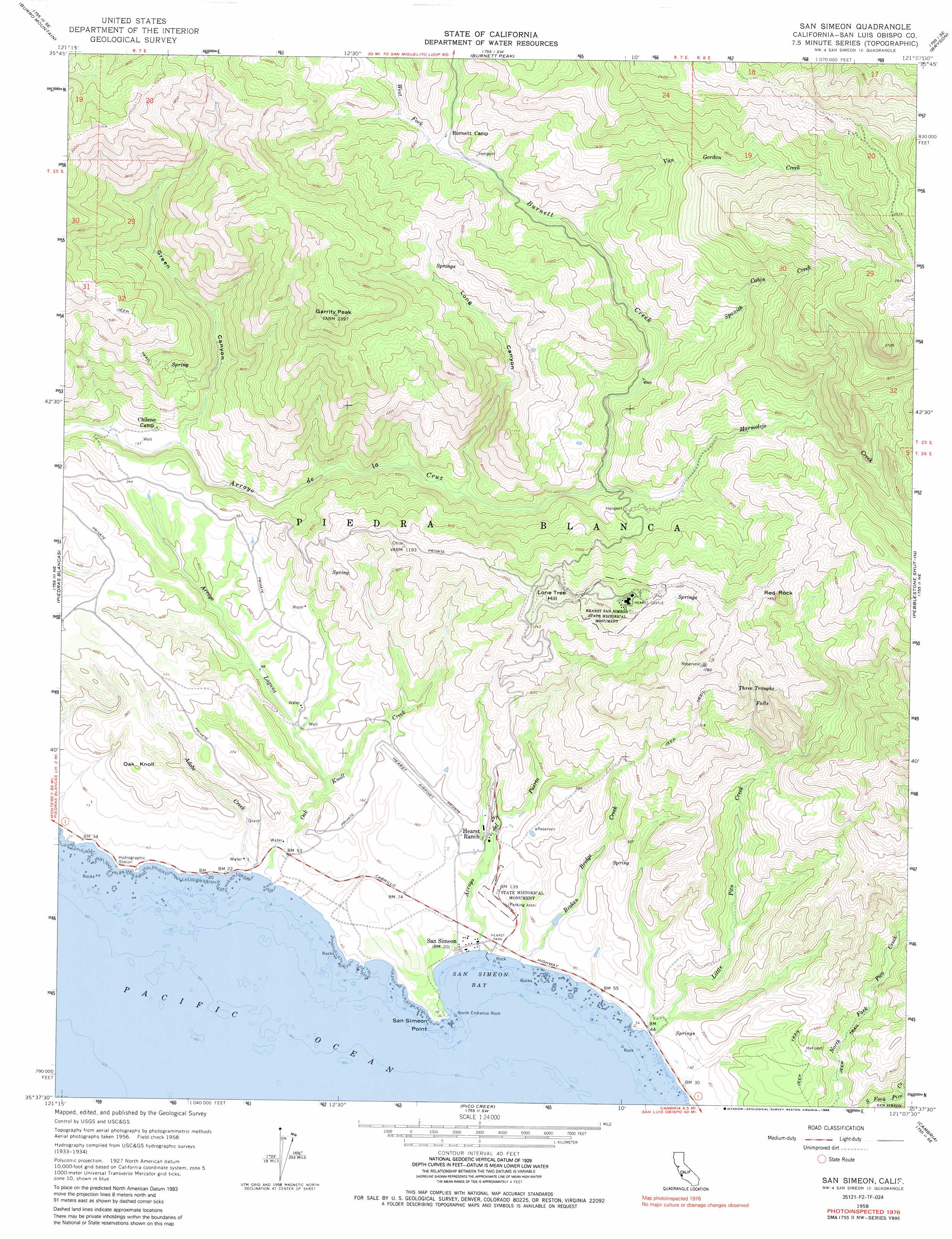
USGS Topo Quad 35121f2 - 1:24,000 scale
| Topo Map Name: | San Simeon |
| USGS Topo Quad ID: | 35121f2 |
| Print Size: | ca. 21 1/4" wide x 27" high |
| Southeast Coordinates: | 35.625° N latitude / 121.125° W longitude |
| Map Center Coordinates: | 35.6875° N latitude / 121.1875° W longitude |
| U.S. State: | CA |
| Filename: | o35121f2.jpg |
| Download Map JPG Image: | San Simeon topo map 1:24,000 scale |
| Map Type: | Topographic |
| Topo Series: | 7.5´ |
| Map Scale: | 1:24,000 |
| Source of Map Images: | United States Geological Survey (USGS) |
| Alternate Map Versions: |
San Simeon CA 1958, updated 1960 Download PDF Buy paper map San Simeon CA 1958, updated 1973 Download PDF Buy paper map San Simeon CA 1958, updated 1988 Download PDF Buy paper map San Simeon CA 1976, updated 1980 Download PDF Buy paper map San Simeon CA 2012 Download PDF Buy paper map San Simeon CA 2015 Download PDF Buy paper map |
1:24,000 Topo Quads surrounding San Simeon
Cape San Martin |
Alder Peak |
Jolon |
Williams Hill |
Hames Valley |
Villa Creek |
Burro Mountain |
Burnett Peak |
Bryson |
Tierra Redondo Mountain |
Piedras Blancas |
San Simeon |
Pebblestone Shut-In |
Lime Mountain |
|
Pico Creek |
Cambria |
Cypress Mountain |
||
Cayucos |
> Back to 35121e1 at 1:100,000 scale
> Back to 35120a1 at 1:250,000 scale
> Back to U.S. Topo Maps home
San Simeon topo map: Gazetteer
San Simeon: Bars
North Entrance Rock elevation 0m 0′San Simeon: Bays
San Simeon Bay elevation 0m 0′San Simeon: Capes
San Simeon Point elevation 19m 62′San Simeon: Falls
Three Troughs Falls elevation 0m 0′San Simeon: Parks
Hearst Park elevation 13m 42′Hearst San Simeon State Historical Monument elevation 446m 1463′
William Randolph Hearst Memorial Beach elevation 3m 9′
San Simeon: Populated Places
San Simeon elevation 6m 19′San Simeon: Springs
Three Troughs elevation 454m 1489′San Simeon: Streams
Adobe Creek elevation 1m 3′Arroyo Laguna elevation 18m 59′
Arryo del Puerto elevation 0m 0′
Broken Bridge Creek elevation 1m 3′
Burnett Creek elevation 231m 757′
Little Pico Creek elevation 2m 6′
Marmolejo Creek elevation 98m 321′
Oak Knoll Creek elevation 1m 3′
Spanish Cabin Creek elevation 145m 475′
West Fork Burnett Creek elevation 209m 685′
San Simeon: Summits
Burnett Peak elevation 710m 2329′Garrity Peak elevation 725m 2378′
Lone Tree Hill elevation 446m 1463′
Oak Knoll elevation 125m 410′
Pine Mountain elevation 343m 1125′
Red Rock elevation 495m 1624′
Rocky Butte elevation 524m 1719′
San Simeon: Valleys
Green Canyon elevation 41m 134′Long Canyon elevation 87m 285′
San Simeon digital topo map on disk
Buy this San Simeon topo map showing relief, roads, GPS coordinates and other geographical features, as a high-resolution digital map file on DVD: