Coinjock Topo Map North Carolina
To zoom in, hover over the map of Coinjock
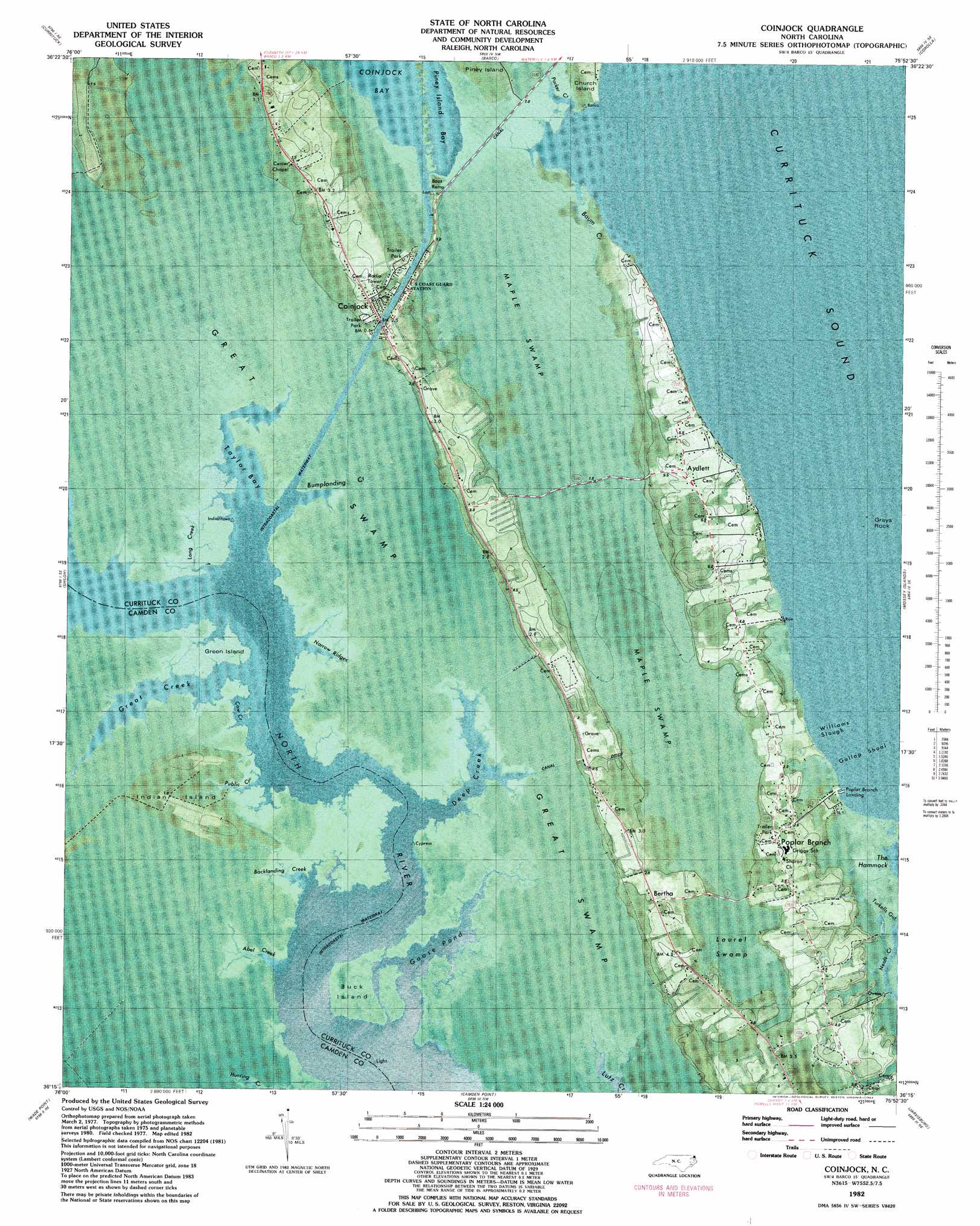
USGS Topo Quad 36075c8 - 1:24,000 scale
| Topo Map Name: | Coinjock |
| USGS Topo Quad ID: | 36075c8 |
| Print Size: | ca. 21 1/4" wide x 27" high |
| Southeast Coordinates: | 36.25° N latitude / 75.875° W longitude |
| Map Center Coordinates: | 36.3125° N latitude / 75.9375° W longitude |
| U.S. State: | NC |
| Filename: | p36075c8.jpg |
| Download Map JPG Image: | Coinjock topo map 1:24,000 scale |
| Map Type: | Orthophoto |
| Topo Series: | 7.5´ |
| Map Scale: | 1:24,000 |
| Source of Map Images: | United States Geological Survey (USGS) |
| Alternate Map Versions: |
Coinjock NC 2010 Download PDF Buy paper map Coinjock NC 2013 Download PDF Buy paper map Coinjock NC 2016 Download PDF Buy paper map |
1:24,000 Topo Quads surrounding Coinjock
Moyock |
Creeds |
Knotts Island |
||
Lambs Corner |
Currituck |
Barco |
Corolla |
|
Elizabeth City |
Shiloh |
Coinjock |
Mossey Islands |
|
Weeksville |
Wade Point |
Camden Point |
Jarvisburg |
Martin Point |
Stevenson Point |
Point Harbor |
Kitty Hawk |
> Back to 36075a1 at 1:100,000 scale
> Back to 36074a1 at 1:250,000 scale
> Back to U.S. Topo Maps home
Coinjock topo map: Gazetteer
Coinjock: Airports
NI-11 Airport elevation 0m 0′Coinjock: Bars
Gallop Shoal elevation 0m 0′Grays Rock elevation 0m 0′
Coinjock: Bays
Cow Creek elevation 0m 0′Piney Island Bay elevation 0m 0′
Piney Island Bay elevation 0m 0′
Taylor Bay elevation 0m 0′
Williams Slough elevation 0m 0′
Coinjock: Capes
Green Island elevation 1m 3′Coinjock: Guts
Green Island Creek elevation 0m 0′Coinjock: Islands
Buck Island elevation 0m 0′Indian Island elevation 1m 3′
Coinjock: Populated Places
Aydlett elevation 4m 13′Bertha elevation 2m 6′
Coinjock elevation 1m 3′
Poplar Branch elevation 4m 13′
Coinjock: Post Offices
Coinjock Post Office elevation 2m 6′Coinjock: Streams
Abel Creek elevation 0m 0′Backlanding Creek elevation 0m 0′
Baum Creek elevation 0m 0′
Bumplanding Creek elevation 0m 0′
Deep Creek elevation 0m 0′
Goose Pond elevation 0m 0′
Great Creek elevation 0m 0′
Long Creek elevation 0m 0′
Narrow Ridges elevation 0m 0′
Public Creek elevation 0m 0′
Coinjock: Swamps
Great Swamp elevation 0m 0′Laurel Swamp elevation 3m 9′
Maple Swamp elevation 1m 3′
Coinjock digital topo map on disk
Buy this Coinjock topo map showing relief, roads, GPS coordinates and other geographical features, as a high-resolution digital map file on DVD:
Atlantic Coast (NY, NJ, PA, DE, MD, VA, NC)
Buy digital topo maps: Atlantic Coast (NY, NJ, PA, DE, MD, VA, NC)
 map DVD")