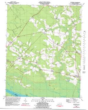
Gatesville Topo Map North Carolina
To zoom in, hover over the map of Gatesville
USGS Topo Quad 36076d7 - 1:24,000 scale
| Topo Map Name: | Gatesville |
| USGS Topo Quad ID: | 36076d7 |
| Print Size: | ca. 21 1/4" wide x 27" high |
| Southeast Coordinates: | 36.375° N latitude / 76.75° W longitude |
| Map Center Coordinates: | 36.4375° N latitude / 76.8125° W longitude |
| U.S. State: | NC |
| Filename: | o36076d7.jpg |
| Download Map JPG Image: | Gatesville topo map 1:24,000 scale |
| Map Type: | Topographic |
| Topo Series: | 7.5´ |
| Map Scale: | 1:24,000 |
| Source of Map Images: | United States Geological Survey (USGS) |
| Alternate Map Versions: |
Gatesville NC 1981, updated 1981 Download PDF Buy paper map Gatesville NC 1981, updated 1992 Download PDF Buy paper map Gatesville NC 2000, updated 2002 Download PDF Buy paper map Gatesville NC 2010 Download PDF Buy paper map Gatesville NC 2013 Download PDF Buy paper map Gatesville NC 2016 Download PDF Buy paper map |
1:24,000 Topo Quads surrounding Gatesville
> Back to 36076a1 at 1:100,000 scale
> Back to 36076a1 at 1:250,000 scale
> Back to U.S. Topo Maps home
Gatesville topo map: Gazetteer
Gatesville: Guts
Spikes Creek elevation 0m 0′Gatesville: Islands
Fort Island elevation 0m 0′Landing Ridge elevation 1m 3′
Gatesville: Populated Places
Ballard Crossroads elevation 6m 19′Buckland elevation 10m 32′
Eleanors Crossroads elevation 10m 32′
Eure elevation 6m 19′
Gatesville elevation 7m 22′
Rays Beach elevation 1m 3′
Riddick Crossroads elevation 9m 29′
Roduco elevation 11m 36′
Sarem elevation 7m 22′
Tarheel elevation 11m 36′
White Oak elevation 11m 36′
Gatesville: Post Offices
Eure Post Office elevation 7m 22′Gatesville Post Office elevation 4m 13′
Gatesville: Reservoirs
Lillys Millpond elevation 4m 13′Taylor Millpond elevation 2m 6′
Gatesville: Streams
Buckhorn Creek elevation 0m 0′Buckland Mill Branch elevation 6m 19′
Cole Creek elevation 0m 0′
Cypress Swamp elevation 4m 13′
Flat Branch elevation 6m 19′
Gum Branch elevation 1m 3′
Hackley Swamp elevation 6m 19′
Jady Branch elevation 1m 3′
Licking Branch elevation 5m 16′
Spices Creek elevation 1m 3′
Gatesville: Swamps
Big Branch elevation 8m 26′Bob Jones Swamp elevation 8m 26′
Horsepen Pocosin elevation 7m 22′
Jones Swamps elevation 8m 26′
Whiteoak Pocosin elevation 11m 36′
Gatesville digital topo map on disk
Buy this Gatesville topo map showing relief, roads, GPS coordinates and other geographical features, as a high-resolution digital map file on DVD:
Atlantic Coast (NY, NJ, PA, DE, MD, VA, NC)
Buy digital topo maps: Atlantic Coast (NY, NJ, PA, DE, MD, VA, NC)


