Winton Topo Map North Carolina
To zoom in, hover over the map of Winton
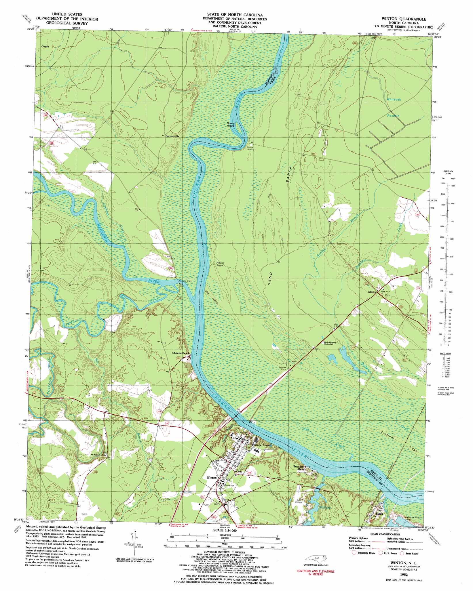
USGS Topo Quad 36076d8 - 1:24,000 scale
| Topo Map Name: | Winton |
| USGS Topo Quad ID: | 36076d8 |
| Print Size: | ca. 21 1/4" wide x 27" high |
| Southeast Coordinates: | 36.375° N latitude / 76.875° W longitude |
| Map Center Coordinates: | 36.4375° N latitude / 76.9375° W longitude |
| U.S. State: | NC |
| Filename: | o36076d8.jpg |
| Download Map JPG Image: | Winton topo map 1:24,000 scale |
| Map Type: | Topographic |
| Topo Series: | 7.5´ |
| Map Scale: | 1:24,000 |
| Source of Map Images: | United States Geological Survey (USGS) |
| Alternate Map Versions: |
Winton NC 1982, updated 1982 Download PDF Buy paper map Winton NC 2000, updated 2002 Download PDF Buy paper map Winton NC 2010 Download PDF Buy paper map Winton NC 2013 Download PDF Buy paper map Winton NC 2016 Download PDF Buy paper map |
1:24,000 Topo Quads surrounding Winton
Capron |
Courtland |
Franklin |
Holland |
Buckhorn |
Boykins |
Sunbeam |
Riverdale |
Gates |
Whaleyville |
Conway |
Murfreesboro |
Winton |
Gatesville |
Merchants Millpond |
Woodland |
Union |
Ahoskie |
Harrellsville |
Mintonsville |
Kelford |
Aulander |
Powellsville |
Colerain |
Valhalla |
> Back to 36076a1 at 1:100,000 scale
> Back to 36076a1 at 1:250,000 scale
> Back to U.S. Topo Maps home
Winton topo map: Gazetteer
Winton: Bends
Sand Banks elevation 5m 16′Winton: Capes
Flax Island elevation 0m 0′Winton: Channels
Long Reach elevation 0m 0′Winton: Dams
Deep Creek Millpond Dam elevation 1m 3′Farmers Chemical Assoc Dam elevation 6m 19′
Winton: Islands
Dowry Island elevation 0m 0′Winton: Populated Places
Bartonsville elevation 10m 32′Chowan Beach elevation 4m 13′
Harrells Mill elevation 6m 19′
Mount Gallows elevation 7m 22′
Pipkin Place elevation 3m 9′
Storys elevation 10m 32′
Tunis elevation 0m 0′
Tuscarora Beach elevation 1m 3′
Winton elevation 13m 42′
Winton: Reservoirs
Farmers Chemical Assoc Lake elevation 6m 19′Mill Pond elevation 1m 3′
Winton: Ridges
Chestnut Ridge elevation 1m 3′Winton: Streams
Beasley Branch elevation 1m 3′Catherine Creek elevation 0m 0′
Deep Creek elevation 0m 0′
Folley Branch elevation 7m 22′
Liverman Creek elevation 1m 3′
Meherrin River elevation 7m 22′
Mill Branch elevation 1m 3′
Mud Creek elevation 8m 26′
Potecasi Creek elevation 1m 3′
Winton: Swamps
Run of Swamp elevation 4m 13′Winton digital topo map on disk
Buy this Winton topo map showing relief, roads, GPS coordinates and other geographical features, as a high-resolution digital map file on DVD:
Atlantic Coast (NY, NJ, PA, DE, MD, VA, NC)
Buy digital topo maps: Atlantic Coast (NY, NJ, PA, DE, MD, VA, NC)
 map DVD")