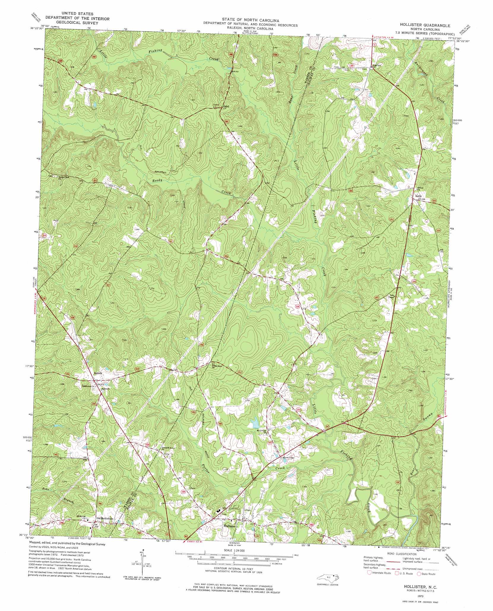
Hollister Topo Map North Carolina
To zoom in, hover over the map of Hollister
USGS Topo Quad 36077c8 - 1:24,000 scale
| Topo Map Name: | Hollister |
| USGS Topo Quad ID: | 36077c8 |
| Print Size: | ca. 21 1/4" wide x 27" high |
| Southeast Coordinates: | 36.25° N latitude / 77.875° W longitude |
| Map Center Coordinates: | 36.3125° N latitude / 77.9375° W longitude |
| U.S. State: | NC |
| Filename: | o36077c8.jpg |
| Download Map JPG Image: | Hollister topo map 1:24,000 scale |
| Map Type: | Topographic |
| Topo Series: | 7.5´ |
| Map Scale: | 1:24,000 |
| Source of Map Images: | United States Geological Survey (USGS) |
| Alternate Map Versions: |
Hollister NC 1973, updated 1977 Download PDF Buy paper map Hollister NC 2010 Download PDF Buy paper map Hollister NC 2013 Download PDF Buy paper map Hollister NC 2016 Download PDF Buy paper map |
1:24,000 Topo Quads surrounding Hollister
Bracey |
South Hill Se |
Gasburg |
Valentines |
Barley |
Warrenton |
Macon |
Littleton |
Thelma |
Roanoke Rapids |
Afton |
Inez |
Hollister |
Aurelian Springs |
Darlington |
Gold Sand |
Centerville |
Essex |
Ringwood |
Enfield |
Justice |
Castalia |
Red Oak |
Drake |
Whitakers |
> Back to 36077a1 at 1:100,000 scale
> Back to 36076a1 at 1:250,000 scale
> Back to U.S. Topo Maps home
Hollister topo map: Gazetteer
Hollister: Dams
Quails Pond Dam elevation 68m 223′Hollister: Parks
Medoc Mountain State Park elevation 98m 321′Hollister: Populated Places
Airlie elevation 87m 285′Arcola elevation 95m 311′
Hollister elevation 75m 246′
Odell elevation 81m 265′
Old Bethlehem elevation 93m 305′
Hollister: Reservoirs
Quails Pond elevation 68m 223′Ryders Pond elevation 59m 193′
Hollister: Streams
Bear Swamp elevation 47m 154′Bens Creek elevation 61m 200′
Porter Creek elevation 50m 164′
Reedy Creek elevation 52m 170′
Reedy Creek elevation 52m 170′
Hollister: Summits
Medoc Mountain elevation 98m 321′Hollister: Trails
Dam Site Loop Trail elevation 60m 196′Discovery Loop Trail elevation 52m 170′
Summit Loop Trail elevation 73m 239′
Hollister digital topo map on disk
Buy this Hollister topo map showing relief, roads, GPS coordinates and other geographical features, as a high-resolution digital map file on DVD:
Atlantic Coast (NY, NJ, PA, DE, MD, VA, NC)
Buy digital topo maps: Atlantic Coast (NY, NJ, PA, DE, MD, VA, NC)
 map DVD")