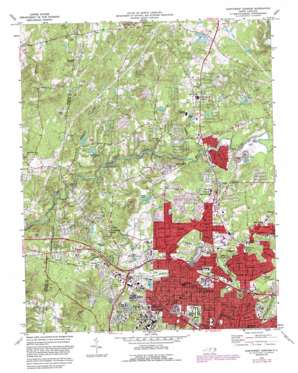
Northwest Durham Topo Map North Carolina
To zoom in, hover over the map of Northwest Durham
USGS Topo Quad 36078a8 - 1:24,000 scale
| Topo Map Name: | Northwest Durham |
| USGS Topo Quad ID: | 36078a8 |
| Print Size: | ca. 21 1/4" wide x 27" high |
| Southeast Coordinates: | 36° N latitude / 78.875° W longitude |
| Map Center Coordinates: | 36.0625° N latitude / 78.9375° W longitude |
| U.S. State: | NC |
| Filename: | o36078a8.jpg |
| Download Map JPG Image: | Northwest Durham topo map 1:24,000 scale |
| Map Type: | Topographic |
| Topo Series: | 7.5´ |
| Map Scale: | 1:24,000 |
| Source of Map Images: | United States Geological Survey (USGS) |
| Alternate Map Versions: |
Northwest Durham NC 1973, updated 1975 Download PDF Buy paper map Northwest Durham NC 1973, updated 1982 Download PDF Buy paper map Northwest Durham NC 1973, updated 1987 Download PDF Buy paper map Northwest Durham NC 1993, updated 1998 Download PDF Buy paper map Northwest Durham NC 2010 Download PDF Buy paper map Northwest Durham NC 2013 Download PDF Buy paper map Northwest Durham NC 2016 Download PDF Buy paper map |
1:24,000 Topo Quads surrounding Northwest Durham
> Back to 36078a1 at 1:100,000 scale
> Back to 36078a1 at 1:250,000 scale
> Back to U.S. Topo Maps home
Northwest Durham topo map: Gazetteer
Northwest Durham: Areas
Sarah P Duke Gardens elevation 111m 364′Northwest Durham: Crossings
Interchange 172 elevation 136m 446′Interchange 173 elevation 121m 396′
Interchange 174 elevation 117m 383′
Interchange 174B elevation 121m 396′
Interchange 176A elevation 99m 324′
Interchange 176B elevation 100m 328′
Interchange 177 elevation 93m 305′
Northwest Durham: Dams
Crystal Lake Dam elevation 102m 334′Eden Lake Dam elevation 134m 439′
Jessie Cole Lake Dam elevation 136m 446′
Newcombs Lake Dam elevation 135m 442′
Sykes Lake Dam elevation 107m 351′
Willowhaven Lake Number One Dam elevation 135m 442′
Willowhaven Lake Number Two Dam elevation 126m 413′
Northwest Durham: Parks
Duke Park elevation 105m 344′Durham County Stadium elevation 111m 364′
Northgate Park elevation 93m 305′
Valley Springs Park elevation 141m 462′
Northwest Durham: Populated Places
Archer Woods elevation 143m 469′Braggtown elevation 119m 390′
Forest Acres elevation 148m 485′
Greymoss elevation 170m 557′
Havenhill elevation 151m 495′
Heather Glen elevation 152m 498′
Heritage Heights elevation 133m 436′
Huckleberry Spring elevation 155m 508′
Huntington Place elevation 131m 429′
Marywood elevation 130m 426′
Meadow Estates elevation 185m 606′
Mill Grove elevation 122m 400′
Pleasant Green Estates elevation 196m 643′
Spring Valley elevation 144m 472′
Suntree elevation 116m 380′
The American Village elevation 123m 403′
University Estates elevation 111m 364′
West Hills elevation 158m 518′
West Hills East elevation 155m 508′
Willow Ridge elevation 168m 551′
Northwest Durham: Post Offices
Eno Valley Post Office elevation 133m 436′West Durham Station Post Office elevation 106m 347′
Northwest Durham: Reservoirs
Crystal Lake elevation 106m 347′Eden Lakes elevation 134m 439′
Jesse Cole Lake elevation 136m 446′
Newcombs Lake elevation 135m 442′
Sykes Lake elevation 107m 351′
Willowhaven Lake Number One elevation 135m 442′
Willowhaven Lake Number Two elevation 126m 413′
Northwest Durham: Streams
Crooked Creek elevation 85m 278′Rhodes Creek elevation 115m 377′
Sevenmile Creek elevation 101m 331′
Northwest Durham digital topo map on disk
Buy this Northwest Durham topo map showing relief, roads, GPS coordinates and other geographical features, as a high-resolution digital map file on DVD:
Western Virginia & Southern West Virginia
Buy digital topo maps: Western Virginia & Southern West Virginia


