Kittrell Topo Map North Carolina
To zoom in, hover over the map of Kittrell
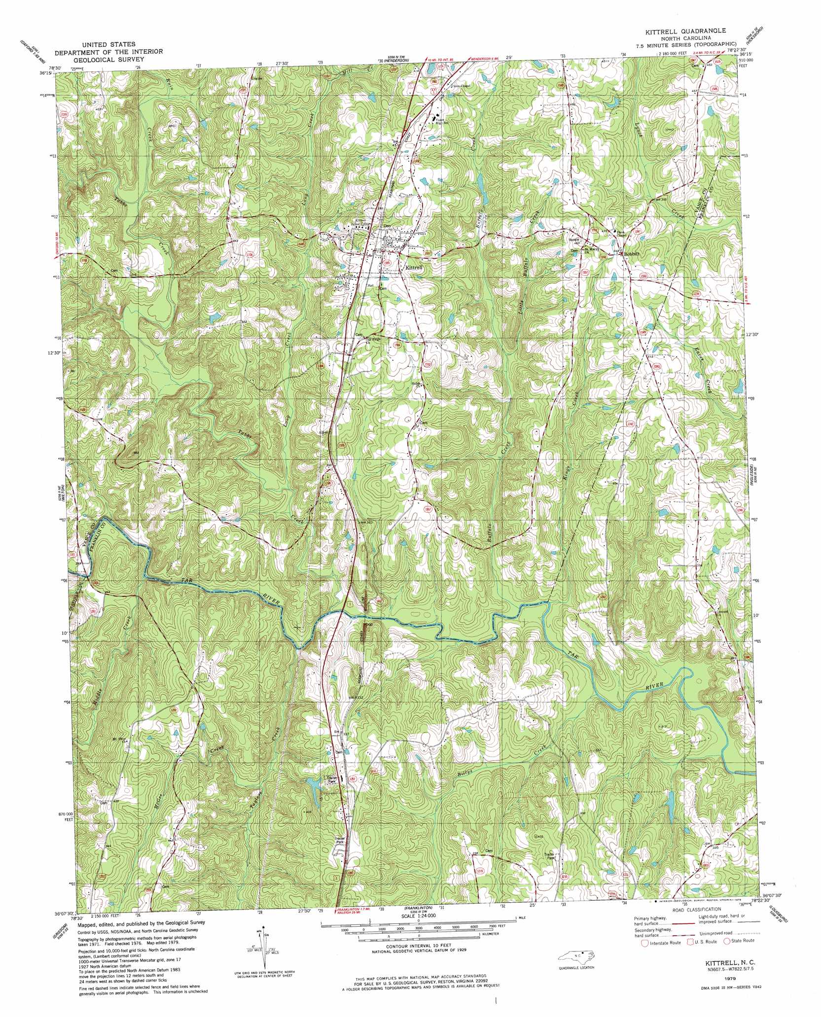
USGS Topo Quad 36078b4 - 1:24,000 scale
| Topo Map Name: | Kittrell |
| USGS Topo Quad ID: | 36078b4 |
| Print Size: | ca. 21 1/4" wide x 27" high |
| Southeast Coordinates: | 36.125° N latitude / 78.375° W longitude |
| Map Center Coordinates: | 36.1875° N latitude / 78.4375° W longitude |
| U.S. State: | NC |
| Filename: | o36078b4.jpg |
| Download Map JPG Image: | Kittrell topo map 1:24,000 scale |
| Map Type: | Topographic |
| Topo Series: | 7.5´ |
| Map Scale: | 1:24,000 |
| Source of Map Images: | United States Geological Survey (USGS) |
| Alternate Map Versions: |
Kittrell NC 1979, updated 1979 Download PDF Buy paper map Kittrell NC 2011 Download PDF Buy paper map Kittrell NC 2013 Download PDF Buy paper map Kittrell NC 2016 Download PDF Buy paper map |
1:24,000 Topo Quads surrounding Kittrell
Satterwhite |
Stovall |
Townsville |
Middleburg |
Warrenton |
Berea |
Oxford |
Henderson |
Vicksboro |
Afton |
Stem |
Wilton |
Kittrell |
Ingleside |
Gold Sand |
Creedmoor |
Grissom |
Franklinton |
Louisburg |
Justice |
Bayleaf |
Wake Forest |
Rolesville |
Bunn West |
Bunn East |
> Back to 36078a1 at 1:100,000 scale
> Back to 36078a1 at 1:250,000 scale
> Back to U.S. Topo Maps home
Kittrell topo map: Gazetteer
Kittrell: Airports
Meadowlark Airport elevation 93m 305′Kittrell: Bridges
Railroad Bridge elevation 65m 213′Kittrell: Dams
Guptons Lake Dam elevation 112m 367′Kittrell: Populated Places
Bobbitt elevation 135m 442′Kittrell elevation 134m 439′
Lynnbrook Estates elevation 124m 406′
Kittrell: Reservoirs
Guptons Lake elevation 112m 367′Kittrell: Streams
Billys Creek elevation 65m 213′Buffalo Creek elevation 65m 213′
Ford Creek elevation 66m 216′
Kings Creek elevation 62m 203′
Little Buffalo Creek elevation 79m 259′
Long Creek elevation 70m 229′
McGee Creek elevation 72m 236′
Middle Creek elevation 68m 223′
Mill Creek elevation 92m 301′
Ruin Creek elevation 77m 252′
Tabbs Creek elevation 65m 213′
Taylors Creek elevation 67m 219′
Kittrell digital topo map on disk
Buy this Kittrell topo map showing relief, roads, GPS coordinates and other geographical features, as a high-resolution digital map file on DVD:
Western Virginia & Southern West Virginia
Buy digital topo maps: Western Virginia & Southern West Virginia