Cluster Springs Topo Map Virginia
To zoom in, hover over the map of Cluster Springs
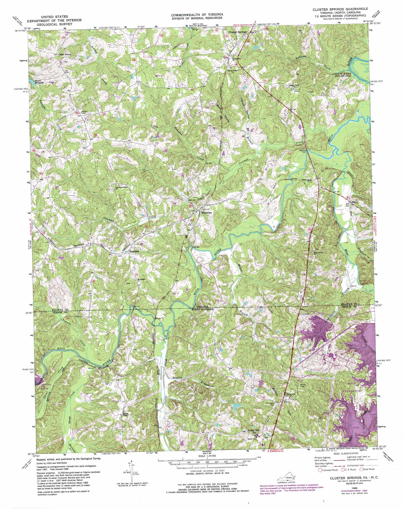
USGS Topo Quad 36078e8 - 1:24,000 scale
| Topo Map Name: | Cluster Springs |
| USGS Topo Quad ID: | 36078e8 |
| Print Size: | ca. 21 1/4" wide x 27" high |
| Southeast Coordinates: | 36.5° N latitude / 78.875° W longitude |
| Map Center Coordinates: | 36.5625° N latitude / 78.9375° W longitude |
| U.S. States: | VA, NC |
| Filename: | o36078e8.jpg |
| Download Map JPG Image: | Cluster Springs topo map 1:24,000 scale |
| Map Type: | Topographic |
| Topo Series: | 7.5´ |
| Map Scale: | 1:24,000 |
| Source of Map Images: | United States Geological Survey (USGS) |
| Alternate Map Versions: |
Cluster Springs VA 1968, updated 1972 Download PDF Buy paper map Cluster Springs VA 1968, updated 1982 Download PDF Buy paper map Cluster Springs VA 1968, updated 1987 Download PDF Buy paper map Cluster Springs VA 2010 Download PDF Buy paper map Cluster Springs VA 2013 Download PDF Buy paper map Cluster Springs VA 2016 Download PDF Buy paper map |
1:24,000 Topo Quads surrounding Cluster Springs
Java |
Vernon Hill |
Halifax |
Scottsburg |
Clover |
Ingram |
Oak Level |
South Boston |
Omega |
Buffalo Springs |
Milton |
Alton |
Cluster Springs |
Virgilina |
Nelson |
Leasburg |
Olive Hill |
Roxboro |
Triple Springs |
Satterwhite |
Ridgeville |
Hurdle Mills |
Timberlake |
Moriah |
Berea |
> Back to 36078e1 at 1:100,000 scale
> Back to 36078a1 at 1:250,000 scale
> Back to U.S. Topo Maps home
Cluster Springs topo map: Gazetteer
Cluster Springs: Dams
Blanes Mill Dam elevation 136m 446′R R Jones Dam elevation 153m 501′
Cluster Springs: Populated Places
Bethel Hill elevation 188m 616′Cedar Grove elevation 160m 524′
Cluster Springs elevation 150m 492′
Denniston elevation 133m 436′
Harmony elevation 149m 488′
Mayo elevation 104m 341′
Rogersville elevation 147m 482′
Cluster Springs: Reservoirs
After Bay Reservoir elevation 107m 351′Blanes Mill Pond elevation 136m 446′
Mayo Reservoir elevation 126m 413′
Cluster Springs: Streams
Bales Spring Branch elevation 100m 328′Bamboo Branch elevation 105m 344′
Bowes Branch elevation 100m 328′
Bowes Branch elevation 100m 328′
Castle Creek elevation 103m 337′
Church Spring Branch elevation 105m 344′
Coleman Creek elevation 100m 328′
Crutchfield Branch elevation 102m 334′
Crutchfield Branch elevation 103m 337′
Dry Creek elevation 101m 331′
Ghent Creek elevation 107m 351′
Halfway Creek elevation 98m 321′
Little Coleman Creek elevation 105m 344′
Marlowe Creek elevation 109m 357′
Mayo Creek elevation 100m 328′
Powells Creek elevation 107m 351′
Powells Creek elevation 107m 351′
Storys Creek elevation 107m 351′
Cluster Springs: Summits
Bethel Hill elevation 185m 606′Cluster Springs digital topo map on disk
Buy this Cluster Springs topo map showing relief, roads, GPS coordinates and other geographical features, as a high-resolution digital map file on DVD:
Western Virginia & Southern West Virginia
Buy digital topo maps: Western Virginia & Southern West Virginia