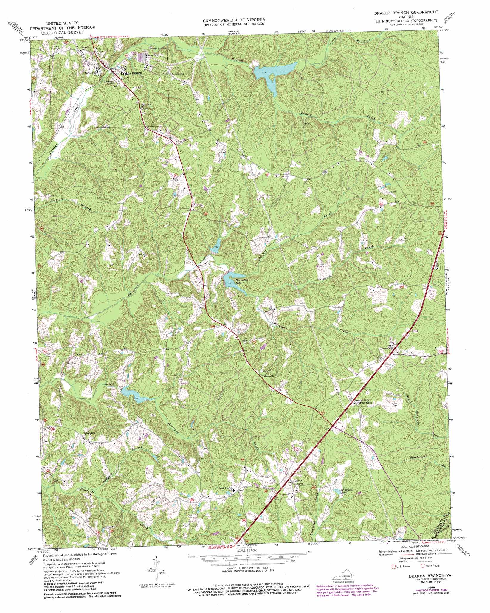
Drakes Branch Topo Map Virginia
To zoom in, hover over the map of Drakes Branch
USGS Topo Quad 36078h5 - 1:24,000 scale
| Topo Map Name: | Drakes Branch |
| USGS Topo Quad ID: | 36078h5 |
| Print Size: | ca. 21 1/4" wide x 27" high |
| Southeast Coordinates: | 36.875° N latitude / 78.5° W longitude |
| Map Center Coordinates: | 36.9375° N latitude / 78.5625° W longitude |
| U.S. State: | VA |
| Filename: | o36078h5.jpg |
| Download Map JPG Image: | Drakes Branch topo map 1:24,000 scale |
| Map Type: | Topographic |
| Topo Series: | 7.5´ |
| Map Scale: | 1:24,000 |
| Source of Map Images: | United States Geological Survey (USGS) |
| Alternate Map Versions: |
Drakes Branch VA 1968, updated 1972 Download PDF Buy paper map Drakes Branch VA 1968, updated 1984 Download PDF Buy paper map Drakes Branch VA 1968, updated 1990 Download PDF Buy paper map Drakes Branch VA 2010 Download PDF Buy paper map Drakes Branch VA 2013 Download PDF Buy paper map Drakes Branch VA 2016 Download PDF Buy paper map |
1:24,000 Topo Quads surrounding Drakes Branch
Red House |
Madisonville |
Abilene |
Hampden Sydney |
Green Bay |
Aspen |
Charlotte Court House |
Eureka |
Keysville |
Meherrin |
Conner Lake |
Saxe |
Drakes Branch |
Fort Mitchell |
Lunenburg |
Scottsburg |
Clover |
Wylliesburg |
Chase City |
Wightman |
Omega |
Buffalo Springs |
Clarksville North |
Boydton |
Baskerville |
> Back to 36078e1 at 1:100,000 scale
> Back to 36078a1 at 1:250,000 scale
> Back to U.S. Topo Maps home
Drakes Branch topo map: Gazetteer
Drakes Branch: Dams
Roanoke Creek Number 49a Dam elevation 121m 396′Roanoke Creek Number 61a Dam elevation 124m 406′
Roanoke Creek Number 62 Dam elevation 132m 433′
Roanoke Creek Number 72a Dam elevation 131m 429′
Drakes Branch: Populated Places
Drakes Branch elevation 115m 377′Drakes Branch: Reservoirs
Horseshoe Lake elevation 124m 406′Langford Pond elevation 152m 498′
Roanoke Creek Site 49a Lake elevation 121m 396′
Roanoke Creek Site 61a Lake elevation 124m 406′
Drakes Branch: Streams
Delaney Creek elevation 125m 410′Jumpin Branch elevation 116m 380′
Lickfort Creek elevation 124m 406′
Reeses Creek elevation 127m 416′
Drakes Branch digital topo map on disk
Buy this Drakes Branch topo map showing relief, roads, GPS coordinates and other geographical features, as a high-resolution digital map file on DVD:
Western Virginia & Southern West Virginia
Buy digital topo maps: Western Virginia & Southern West Virginia