Hillsborough Topo Map North Carolina
To zoom in, hover over the map of Hillsborough
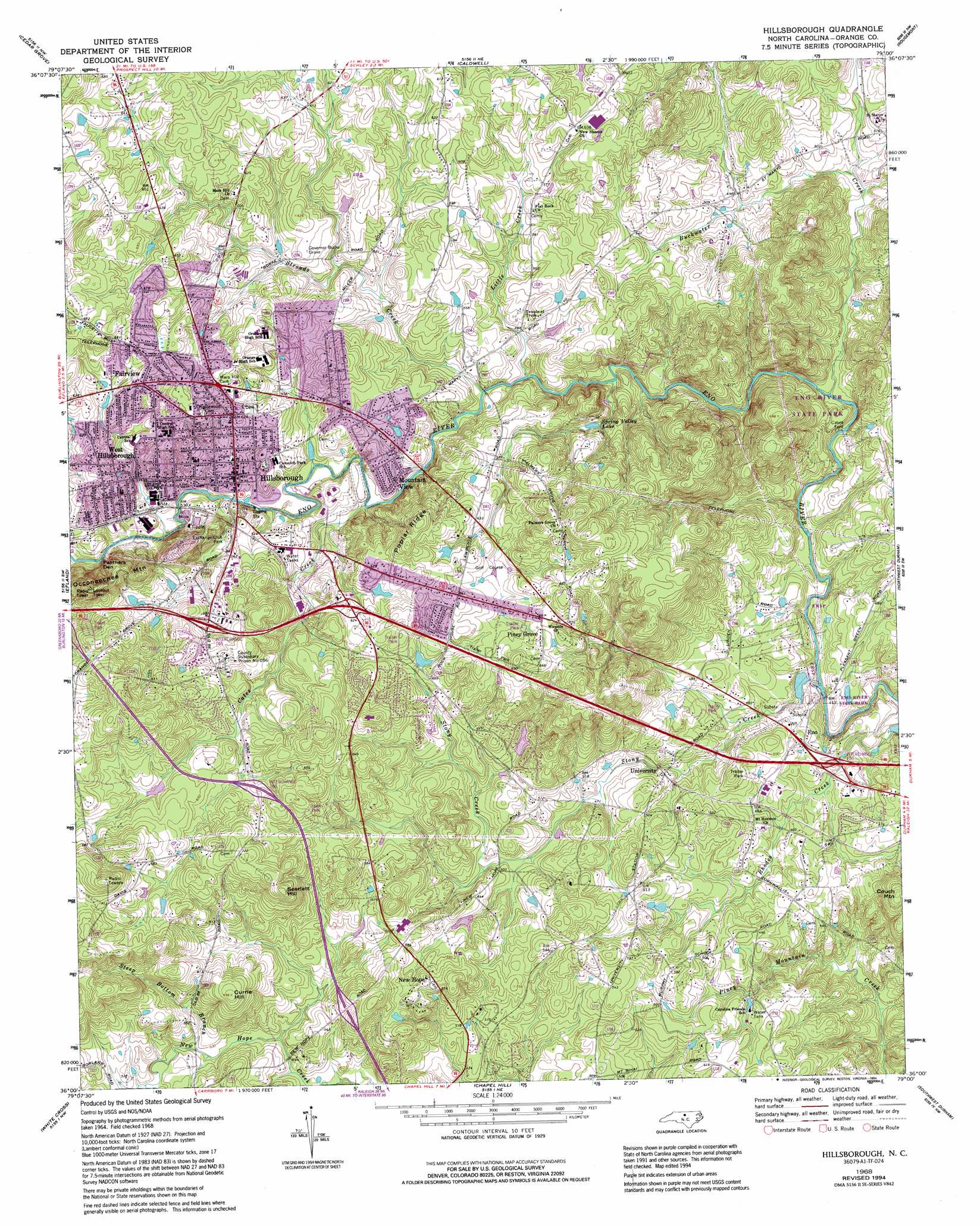
USGS Topo Quad 36079a1 - 1:24,000 scale
| Topo Map Name: | Hillsborough |
| USGS Topo Quad ID: | 36079a1 |
| Print Size: | ca. 21 1/4" wide x 27" high |
| Southeast Coordinates: | 36° N latitude / 79° W longitude |
| Map Center Coordinates: | 36.0625° N latitude / 79.0625° W longitude |
| U.S. State: | NC |
| Filename: | o36079a1.jpg |
| Download Map JPG Image: | Hillsborough topo map 1:24,000 scale |
| Map Type: | Topographic |
| Topo Series: | 7.5´ |
| Map Scale: | 1:24,000 |
| Source of Map Images: | United States Geological Survey (USGS) |
| Alternate Map Versions: |
Hillsborough NC 1968, updated 1970 Download PDF Buy paper map Hillsborough NC 1968, updated 1979 Download PDF Buy paper map Hillsborough NC 1968, updated 1982 Download PDF Buy paper map Hillsborough NC 1968, updated 1989 Download PDF Buy paper map Hillsborough NC 1968, updated 1994 Download PDF Buy paper map Hillsborough NC 1997, updated 1999 Download PDF Buy paper map Hillsborough NC 2010 Download PDF Buy paper map Hillsborough NC 2013 Download PDF Buy paper map Hillsborough NC 2016 Download PDF Buy paper map |
1:24,000 Topo Quads surrounding Hillsborough
Anderson |
Ridgeville |
Hurdle Mills |
Timberlake |
Moriah |
Burlington Ne |
Cedar Grove |
Caldwell |
Rougemont |
Lake Michie |
Mebane |
Efland |
Hillsborough |
Northwest Durham |
Northeast Durham |
Saxapahaw |
White Cross |
Chapel Hill |
Southwest Durham |
Southeast Durham |
Silk Hope |
Bynum |
Farrington |
Green Level |
Cary |
> Back to 36079a1 at 1:100,000 scale
> Back to 36078a1 at 1:250,000 scale
> Back to U.S. Topo Maps home
Hillsborough topo map: Gazetteer
Hillsborough: Crossings
Interchange 161 elevation 203m 666′Interchange 163 elevation 200m 656′
Interchange 164 elevation 180m 590′
Interchange 165 elevation 183m 600′
Interchange 170 elevation 135m 442′
Interchange 261 elevation 192m 629′
Interchange 263 elevation 169m 554′
Hillsborough: Dams
Ben Johnson Lake Dam elevation 181m 593′Fox Pond Dam elevation 153m 501′
Freeland Dam elevation 181m 593′
Piedmont Minerals Dam elevation 157m 515′
Strayhorn Pond Dam elevation 151m 495′
Hillsborough: Lakes
Spring Valley Lake elevation 157m 515′Hillsborough: Parks
Eno River State Park elevation 160m 524′Exchange Club Park elevation 163m 534′
Hillsborough: Populated Places
Bluffs of Eno elevation 155m 508′Brigadoon elevation 140m 459′
Cabes Ford elevation 126m 413′
Colonial Hills elevation 196m 643′
Colonial Park elevation 199m 652′
Cornwallis Hills elevation 197m 646′
Dimmocks Mill elevation 168m 551′
Eastwood elevation 181m 593′
Eno elevation 141m 462′
Fairview elevation 200m 656′
Falls of New Hope elevation 154m 505′
Greenbriar elevation 133m 436′
Hideaway Estates elevation 182m 597′
Hillcrest elevation 180m 590′
Hillsborough elevation 166m 544′
Jappa Oaks elevation 184m 603′
Kingsboro Estates elevation 186m 610′
Mountain View elevation 158m 518′
New Hope elevation 176m 577′
Oak Ridge elevation 197m 646′
Oakdale Farms elevation 196m 643′
Orange Heights elevation 190m 623′
Piney Grove elevation 200m 656′
Poplar Ridge elevation 187m 613′
Rosewood elevation 191m 626′
Stagecoach Run elevation 215m 705′
Strayhorn Hills elevation 174m 570′
Sunshine Acres elevation 212m 695′
University elevation 145m 475′
University Acres elevation 172m 564′
Walnut Cove elevation 156m 511′
West Hillsborough elevation 187m 613′
Whispering Pines elevation 143m 469′
Wildwood elevation 208m 682′
Wilkerson Acres elevation 188m 616′
Windy Hill Farm elevation 156m 511′
Hillsborough: Post Offices
Hillsborough Post Office elevation 164m 538′Hillsborough: Reservoirs
Ben Johnson Lake elevation 181m 593′Lake Overlook elevation 164m 538′
Noname elevation 181m 593′
Piedmont Minerals Lake elevation 157m 515′
Strayhorn Pond elevation 151m 495′
Hillsborough: Ridges
Panthers Den elevation 190m 623′Poplar Ridge elevation 220m 721′
Hillsborough: Streams
Buckwater Creek elevation 129m 423′Cates Creek elevation 148m 485′
Little Creek elevation 146m 479′
Steep Bottom Branch elevation 150m 492′
Stony Creek elevation 123m 403′
Strouds Creek elevation 146m 479′
Hillsborough: Summits
Couch Mountain elevation 194m 636′Currie Hill elevation 210m 688′
Occoneechee Mountain elevation 261m 856′
Scarlett Hill elevation 227m 744′
Hillsborough digital topo map on disk
Buy this Hillsborough topo map showing relief, roads, GPS coordinates and other geographical features, as a high-resolution digital map file on DVD:
Western Virginia & Southern West Virginia
Buy digital topo maps: Western Virginia & Southern West Virginia